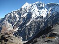
Trisul

Last updated
Trisul 1 and 2 as seen from Brahma Tal trek Trisul 1 and2.jpg
Trisul 1 and 2 as seen from Brahma Tal trek
Trisul on the way to Roopkund from Bedni Bugyal Trisul peak from bedni bugyal.jpg
Trisul on the way to Roopkund from Bedni Bugyal
Trisul 1 from Kausani Mount Trishul - 1.jpg
Trisul 1 from Kausani

Trishul
Trishul.jpg
Trishul from Bedini Bugyal
Highest point
Elevation 7,120 m (23,360 ft) [1] [2]
Prominence 1,616 m (5,302 ft) [3]
Listing Ultra
Coordinates 30°18′46″N79°46′38″E / 30.31278°N 79.77722°E / 30.31278; 79.77722 Coordinates: 30°18′46″N79°46′38″E / 30.31278°N 79.77722°E / 30.31278; 79.77722 [1]
Geography
India relief location map.jpg
Red triangle with thick white border.svg
Trisul
India
Location Bageshwar, Uttarakhand, India
Parent range Kumaun Himalaya
Climbing
First ascent 12 June 1907 by Tom Longstaff, A. Brocherel, H. Brocherel, Karbir [4]
Easiest route Northeast flank/north ridge: snow/glacier climb

Trisul is a group of three Himalayan mountain peaks of western Kumaun, Uttarakhand, with the highest (Trisul I) reaching 7120m. The three peaks resemble a trident - in Hindi/Sanskrit, Trishula, trident, is the weapon of Shiva. The Trishul group forms the southwest corner of the ring of peaks enclosing the Nanda Devi Sanctuary, about 15 kilometres (9 mi) west-southwest of Nanda Devi itself. The main peak, Trisul I, was the first peak over 7,000 m (22,970 ft) to have ever been climbed, in 1907.

Contents

Trishul seen from Junargali Trisul1.JPG
Trishul seen from Junargali
Sunset on Trishul Peak, photographed from Ranikhet, India Trishul peak in the golden hour.jpg
Sunset on Trishul Peak, photographed from Ranikhet, India
Trisul Peak view from Ratanpur Kalan dist. Moradabad during lockdown on 10 May 2020 I.S.T 6.55 pm. Approx aerial distance of the peak is 216 km. Trisul Peak Ratanpur kalan.jpg
Trisul Peak view from Ratanpur Kalan dist. Moradabad during lockdown on 10 May 2020 I.S.T 6.55 pm. Approx aerial distance of the peak is 216 km.

Description of the massif and neighbouring peaks

The three peaks are named Trisul I, Trisul II, and Trisul III. The massif is a north-south ridge, with Trisul I at the north end and Trisul III at the south. The massif runs roughly North-South, and hence appears compressed when viewed from the south (Ranikhet, Kausani), and more stretched out from the Southeast (Chamoli, Bedini Bugyal).

Nanda Ghunti lies a few Kilometres to the northwest, while Mrigthuni is just to the southeast.

MountainHeight (m)Height (ft)Coordinates Prominence (m)First ascent
Trisul I7,12023,359 30°18′46″N79°46′38″E / 30.31278°N 79.77722°E / 30.31278; 79.77722 16161907
Trisul II6,690 [5] 21,949 30°17′24″N79°46′12″E / 30.29000°N 79.77000°E / 30.29000; 79.77000 [6] <200 [7] 1960
Trisul III6,00719,708 30°15′00″N79°46′12″E / 30.25000°N 79.77000°E / 30.25000; 79.77000 <200 [7] 1960

Climbing history

Trisul I

Trisul from Kausani, Uttarakhand Trisul mountain (00283).JPG
Trisul from Kausani, Uttarakhand
Sunset on Trisul Trisul.jpg
Sunset on Trisul

T. G. Longstaff made the first climbing reconnaissance of Trisul, in September 1905, focussing on the western and southern sides. He returned in 1907 with two other Britons, three Alpine guides, and a number of Gurkhas. They ascended through the Rishiganga valley, to the north of the peak, onto the Trisul Glacier, which lies on the east side. From there they climbed the northeast flank to the north ridge, reaching the summit on 12 June. At the time Trisul was probably the highest mountain to have been climbed. [8] The climb was noted also for the first use of supplementary oxygen in a major climb. [9] During the 1950s Harold Williams led Indian Army expeditions to the summit.[ citation needed ]

Routes on the west face and south ridge of Trisul I have also been climbed. The south side was first ascended in 1976 by a Yugoslavian expedition, with Slovenian climbers Andrej Graseli and Štefan Marenče reaching the peak on 15 May, followed by Vanja Matijevec the following day. [10]

Trisul II and III

Trisul II and Trisul III were first climbed in 1960 by the Yugoslav team JAHO I  [ sl ]. They climbed from the Bidalgwar glacier, achieving the summit of Trisul II via the southern ridge and Trisul III via the north ridge.[ citation needed ]

Another Yugoslav expedition made the first traverse of the three peaks in 1987, and two members paraglided from the summit.[ citation needed ]

Access

The Trisul massif can be accessed via the following route: Almora - Kausani - Garur- Gwaldam - Debal - Bagargad - Wan - Bedini Bugyal - Kalu Vinayak - Roopkund - Trisul.

Related Research Articles

Kangchenjunga Third highest mountain in the world

Kangchenjunga, also spelt Kanchenjunga, is the third highest mountain in the world. It rises with an elevation of 8,586 m (28,169 ft) in a section of the Himalayas called Kangchenjunga Himal delimited in the west by the Tamur River, in the north by the Lhonak Chu and Jongsang La, and in the east by the Teesta River. It lies between India and Nepal, with three of the five peaks, namely Main, Central and South, directly on the border, and the peaks West and Kangbachen in Nepal's Taplejung District.

Nanda Devi Second-highest mountain in India

Nanda Devi is the second-highest mountain in India, after Kangchenjunga, and the highest located entirely within the country. It is the 23rd-highest peak in the world.

Kamet Mountain in Uttarakhand, India

Kamet is the second highest mountain in the Garhwal region of Uttarakhand, India, after Nanda Devi. It lies in the Chamoli District of Uttarakhand. Its appearance resembles a giant pyramid topped by a flat summit area with two peaks.

Tirsuli

Tirsuli is a Himalayan mountain peak in the Pithoragarh district of Uttarakhand, India. It is part of the complex of mountains, including Tirsuli West, Hardeol, Dunagiri, Changabang, and Kalanka, which make up the northeast wall of the Nanda Devi Sanctuary, in the Garhwal Himalaya. It rises at the northern end of the Johar Valley, which drains into the Gori Ganga. This peak should not be confused with nearby Trisul, which is on the southwest side of the Sanctuary.

Nanda Kot

Nanda Kot is a mountain peak of the Himalaya range located in the Pithoragarh district of Uttarakhand state in India. It lies in the Kumaon Himalaya, just outside the ring of peaks enclosing the Nanda Devi Sanctuary, 15 kilometres (9 mi) southeast of Nanda Devi itself. The name Nanda Kot literally means "Nanda's Fortress" and refers to the abode of one of the sacred forms of the Hindu Goddess Parvati who in legend has made her sanctuary amongst the ring of lofty mountains in the region.

The Nanda Devi National Park or Nanda Devi Biosphere Reserve, established in 1982 is a national park situated around the peak of Nanda Devi in Chamoli Garhwal district of Uttarakhand, in northern India. The entire park lies at an elevation of more than 3,500 m (11,500 ft) above mean sea level.

Abi Gamin is a Himalayan mountain peak mostly situated in the Chamoli district of Uttarakhand state in India, 2 km (1.2 mi) northeast of Kamet. Its summit is on the border with Tibet and its northern slope is in the Ngari Prefecture of Tibet.

Swargarohini Mountain massif in Uttarakhand, India

Swargarohini is a mountain massif in the Saraswati (Bandarpunch) Range of the Garhwal Himalaya. It lies in the Uttarkashi District of the northern Indian state of Uttarakhand, west of the Gangotri group of peaks. It comprises four separate peaks, the main peak Swargarohini I is the subject of this article.

In the history of mountaineering, the world altitude record referred to the highest point on the Earth's surface which had been reached, regardless of whether that point was an actual summit. The world summit record referred to the highest mountain to have been successfully climbed. The terms are most commonly used in relation to the history of mountaineering in the Himalaya and Karakoram ranges, though modern evidence suggests that it was not until the 20th century that mountaineers in the Himalaya exceeded the heights which had been reached in the Andes. The altitude and summit records rose steadily during the early 20th century until 1953, when the ascent of Mount Everest made the concept obsolete.

Dunagiri (mountain)

Dunagiri is one of the high peaks of the Chamoli District Himalayas in the northern Indian state of Uttarakhand. It lies at the northwest corner of the Sanctuary Wall, A ring of peaks surrounding Nanda Devi and enclosing the Nanda Devi Sanctuary.

Sunanda Devi

Nanda Devi East, locally known as Sunanda Devi, is the lower of the two adjacent peaks of the highest mountain in Uttarakhand and second highest mountain in India; Nanda Devi is its higher twin peak. Nanda Devi and Nanda Devi East are part of the Garhwal Himalayas, and are located in the state of Uttarakhand. The graceful peaks of twin mountains are visible from almost everywhere in Kumaon. The first ascent to Nanda Devi East peak in recorded history appears to be in 1939 by Jakub Bujak and Janusz Klarner. The elevation of Nanda Devi East is 7,434 m (24,390 ft) and its prominence is 260 m (850 ft).

Shipton–Tilman Nanda Devi expeditions Himalayan mountaineering expeditions in 1930s

The Shipton–Tilman Nanda Devi expeditions took place in the 1930s. Nanda Devi is a Himalayan mountain in what was then the Garhwal District in northern India, just west of Nepal, and at one time it was thought to be the highest mountain in the world.

The role of The Doon School in Indian mountaineering describes the formative links between The Doon School, an all-boys boarding school in Dehradun, India and early post-Independence Indian mountaineering. From the 1940s onwards, Doon's masters and students like A.E. Foot, R.L. Holdsworth, J.A.K. Martyn, Gurdial Singh, Jack Gibson, Aamir Ali, Hari Dang, Nandu Jayal, were among the first to go on major Himalayan expeditions in a newly independent nation. These early expeditions contributed towards laying the foundation of mountaineering in an independent India.

Bhagirathi Massif

Bhagirathi Massif or Bhagirathi Group is a mountain range of Garhwal Himalaya in Gangotri Glacier Uttarakhand India, It has four peaks between 6856 meter and 6193 meter. The Bhagirathi I summits is 6856 meter or 22493 feet. It was first climbed by A Japanese team in 1980. It is surrounded by Glaciers on four side on the eastern side of the Massif is Vasuki Glacier, on the western side its Gangotri Glacier the main glacier in this area, northern side is surrounded by Chaturangi Glacier and southern side guarded by Swachhhand Glacier.

Maiktoli

Maiktoli is a mountain of Kumaun Himalayas located in the Bageshwar district of Uttarakhand state in India. It stands at 6,803 metres (22,320 ft). It is jointly the 32nd highest located entirely within the uttrakhand India. Nanda Devi is the highest mountain in this category. Maiktoli is 479th highest peak in the world. It is located at the southern rim of Nanda Devi Sanctuary. Maiktoli is located just south east of Devtoli and south east of Trisul. On the north east side lies Nanda Devi and Panwali Dwar. On the south west side lies Tharkot.

Bethartoli is a mountain of the Garhwal Himalaya in Uttarakhand India.The elevation of Bethartoli is 6,352 metres (20,840 ft) and its prominence is 463 metres (1,519 ft). It is 108th highest located entirely within the Uttrakhand. Nanda Devi, is the highest mountain in this category. It lies 6.6 km east of Ronti and 7.2 km north of Trisul I 7,120 metres (23,360 ft). It lies 9.9 km NW of Devistan I 6,678 metres (21,909 ft). It is located 17.6 km west of Nanda Devi 7,816 metres (25,643 ft) and 7.2 km SW lies Nanda Ghunti 6,309 metres (20,699 ft).

Bethartoli South is a mountain of the Garhwal Himalaya in Uttarakhand, India.The elevation of Bethartoli South is 6,318 metres (20,728 ft) and its prominence is 277 metres (909 ft). It is 117th highest located entirely within the Uttrakhand. Nanda Devi, is the highest mountain in this category. It is situated in the Nanda Devi sanctuary. It lies 1.3 km south of Bethartoli 6,352 metres (20,840 ft) its nearest higher neighbor. It is 17 km west of Nanda Devi 7,816 metres (25,643 ft)and it lies 8.9 km NW of Devistan 6,678 metres (21,909 ft).

Rishi Kot is a mountain of the Garhwal Himalaya in Uttarakhand India. Rishi Kot means “the Rishis’ fortress”. The elevation of Rishi Kot is 6,236 metres (20,459 ft) and its prominence is 436 metres (1,430 ft). It is 134th joint highest located entirely within the Uttrakhand. Nanda Devi, is the highest mountain in this category. It lies 5.7 km SW of Changabang 6,864 metres (22,520 ft) its nearest higher neighbor and 7.1 km south of Dunagiri 7,066 metres (23,182 ft). Bethartoli 6,393 metres (20,974 ft) lies 13.4 km SW and 11.7 km SSE lies Nanda Devi 7,816 metres (25,643 ft).

Devi Mukut is a mountain of the Garhwal Himalaya in Uttarakhand, India. It stands near the western rim of the Nanda Devi Sanctuary between Devistan and Devtoli. The elevation of Devi Mukut is 6,648 metres (21,811 ft). It is 59th highest located entirely within the Uttrakhand. Nanda Devi, is the highest mountain in this category. It lies 3.3 km south of Devistan I 6,678 metres (21,909 ft) its nearest higher neighbor. Devtoli 6,788 metres (22,270 ft) stands at 3.3 km SSW. It stands 4.3 km north of Maiktoli 6,803 metres (22,320 ft) and Nanda Devi lies 11.9 km NE.

References

  1. 1 2 H. Adams Carter, "Classification of the Himalaya", American Alpine Journal , 1985, p. 137.
  2. Some sources give 7,172 m (23,530 ft).
  3. "High Asia I: The Karakoram, Pakistan Himalaya and India Himalaya (north of Nepal)". Peaklist.org. Retrieved 28 May 2014.
  4. Jill Neate, High Asia: An Illustrated History of the 7000 Metre Peaks, ISBN   0-89886-238-8.
  5. This elevation is from the Himalayan Index. Some sources give 6,660 m (21,850 ft).
  6. From the Himalayan Index.
  7. 1 2 Garhwal-Himalaya-Ost (1:150,000 scale topographic map), Swiss Foundation for Alpine Research, 1992; based on maps by the Survey of India.
  8. Mason, Kenneth (1955). Abode of the Snow. Rupert Hart-Davis. p. 117. Reprinted 1987 by Diadem Books, ISBN   978-0-906371-91-6
  9. John B. West (May 2003). "George I. Finch and his pioneering use of oxygen for climbing at extreme altitudes". Journal of Applied Physiology. 94 (5): 1702–1713. doi:10.1152/japplphysiol.00950.2002. PMID   12679344. Quote: "The first use of supplementary oxygen in the Himalayas was apparently in 1907 when A. L. Mumm, Tom Longstaff, and Charles Bruce went to the Garhwal and made the first ascent of Trisul (7,127 m), which remained the highest summit to be climbed for 21 years."
  10. Jevremović, Pavle (2001). Nebesko predvorje: Himalaji. Beogradsko mašinsko grafičko prezueće. p. 37. ISBN   86-7330-117-3

Other sources