
Aligarh is a city in the state of Uttar Pradesh in India. It is the administrative headquarters of Aligarh district, and lies 342 kilometres (213 mi) northwest of state capital Lucknow and approximately 130 kilometres (81 mi) southeast of the capital, New Delhi. The cities and districts which adjoin Aligarh are: Gautam Buddha Nagar, Bulandshahr, Sambhal, Badaun, Kasganj, Hathras, Etah and Mathura, as well as Palwal district of Haryana. As of 2011, Aligarh is the 53rd most populous city in India.

Moradabad is an industrial city, commissionerate, and municipal corporation in Moradabad district of the Indian state of Uttar Pradesh. It is situated on the banks of the Ramganga river, at a distance of 167 km (104 mi) from the national capital, New Delhi and 344 km north-west of the state capital, Lucknow. Based on the 2011 census, it is 10th most populous city in the state and 54th most populous city in the country. It is one of the largest cities in the Western UP region, serving as a crucial hub for employment, education, industry, culture, and administration.

Bijnor district is one of the 75 districts in the state of Uttar Pradesh in India. Bijnor city is the district headquarters. The government of Uttar Pradesh seeks its inclusion in National Capital Region (NCR) due to its close proximity to NCT of Delhi.
Kashipur is a city of Udham Singh Nagar district in the Indian state of Uttarakhand, and one of its seven subdivisions. Located in the western part of Udham Singh Nagar district, it is Kumaun's third most populous city and the sixth most populous in Uttarakhand. According to the 2011 Census of India, the population is 121,623 for the city of Kashipur and 283,136 for Kashipur Tehsil. Kashipur also has IIM Kashipur, one of the thirteen Indian Institutes of Managements the government has set up during the Eleventh Five-year Plan.

Ailum, is Nagar panchayat town in Shamli district in the Indian state of Uttar Pradesh, situated in the upper doab region of River Ganga and Yamuna. It is located at a distance of 75 km from National Capital New Delhi and a part of the National Capital Region (NCR) of India.
Chandpur is a town and a municipal board in Bijnor district in the Indian state of Uttar Pradesh, India.
Rajakhera is a city and a municipality situated near the banks of the Chambal River in Dholpur district in the Eastern part of the Indian state of Rajasthan. Its part of Braj region and the local language has Braj Bhasha dialect. The culture is fused with Rajasthan and its border states.
Sarsawa is a town at the border of Haryana and a municipal board in Saharanpur district in the Indian state of Uttar Pradesh.

Sitarganj is a city and a municipal board in Udham Singh Nagar district in the Indian state of Uttarakhand. Now it is home to the Integrated Industrial Estate Sitarganj (IIE) being developed by State Industrial Development Corporation of Uttarakhand Limited (SIDCUL).

Joya is a nagar panchayat located along highway NH-24 in Amroha district in the Western Uttar Pradesh. It is predominantly a milk producing city. Joya was a gram panchayat before 1988. The late Abrar Hussain was the first chairman of Joya in 1988.

Kunda is a town and a Tehsil in Pratapgarh district in the Indian state of Uttar Pradesh.
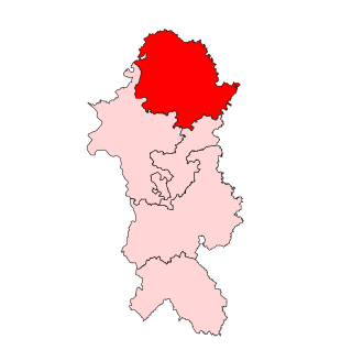
Moradabad Lok Sabha constituency is one of the 80 Lok Sabha (parliamentary) constituencies in western Uttar Pradesh state in northern India. It is located in the northern part of the state at a distance of 167 km from the national capital, New Delhi. Formed before the 1952 elections, it represents Moradabad district in the lower house of Indian Parliament.
Fatanpur is a village situated about 30 km southwest of Moradabad in Uttar Pradesh, India. This village was established by Dahiya Jats from the Haryana State of India. The Jat clan of that area now comprises the Dahiyas,amit arvind pradeep pavan deepak sonu sanklan Tobias, Maliks, and Jatranas. The other castes found there are Saini, Thakur(nai), and Harijans. Most of this village's population is dependent on agriculture. The NREGA scheme is in progress in the village and many of the boys there have joined the Indian Armed Forces in recent years.

Amethi is one of the 75 districts of the northern Indian state of Uttar Pradesh. This district is a part of Ayodhya division in the Awadh region of Uttar Pradesh. It covers an area of 2,329.11 km2. Gauriganj is the administrative headquarters of the district.
Rehar is a small town in Bijnor district, in Uttar Pradesh state, India.

Sambhal district is a district of Uttar Pradesh state in India. The district headquarter is Bahjoi town. 993 villages and 16 police stations fall under Sambhal district.

Kanth Assembly constituency is one of the 403 constituencies of the Uttar Pradesh Legislative Assembly, India. It is a part of the Moradabad district and one of the five assembly constituencies in the Moradabad Lok Sabha constituency. First election in this assembly constituency was held in 1957 after the delimitation order was passed in 1956. The constituency was assigned identification number 25 after "Delimitation of Parliamentary and Assembly Constituencies Order, 2008" was passed in the year 2008.
Thakurdwara is one of the 403 Legislative Assembly constituencies of Uttar Pradesh state in India.
Nawab Jan is an Indian politician and a member of the 16th Legislative Assembly of Uttar Pradesh and 17th Legislative Assembly of Uttar Pradesh, India. He represents the Thakurdwara constituency of Uttar Pradesh and is a member of the Samajwadi Party political party.
Ratupura (Hindi:रतूपुरा) is a village of Thakurdwara Tehsil, Moradabad District, Uttar Pradesh, India.
