Khammam is the city in Khammam district of the Indian state of Telangana. It is the fourth largest city in the state. It is the headquarters of the Khammam district and Khammam mandal also. It is located about 193 kilometres (120 mi) east of the state capital, Hyderabad, 61 kilometres (38 mi) from Suryapet, 120 kilometres (75 mi) from Warangal and also it is located about 121 kilometres (75 mi) North of the Andhra Pradesh state capital, Amaravathi. The river Munneru flows on the western side of the city. As of 2011 census of India, Khammam urban agglomeration has a population of 313,504. However, on 19 October 2012, the civic body of Khammam was upgraded to a municipal corporation. Post- upgradation to corporation, the population of Khammam was approximated to be 3,07,000. During 2014-2023 under BRS regime Khammam got a major changeover, roads expansion, Medical College, Engineering College, ITHub.

Karimnagar is a city and District Headquarters in the Indian state of Telangana. Karimnagar is a major urban agglomeration and the third largest city in the state. It is governed by the Municipal Corporation and is the headquarters of the Karimnagar district. It is situated on the banks of Manair River, which is a tributary of the Godavari River. It is the third largest and fastest growing urban settlement in the state, according to the 2011 census. It has registered a population growth rate of 45.46% and 38.87% respectively over the past two decades between 1991 and 2011, which is the highest growth rate among major cities of Telangana. It serves as a major educational and health hub for the northern districts of Telangana. It is a major business center and widely known for its agricultural and granite industries, earning the nickname "City of Granites."
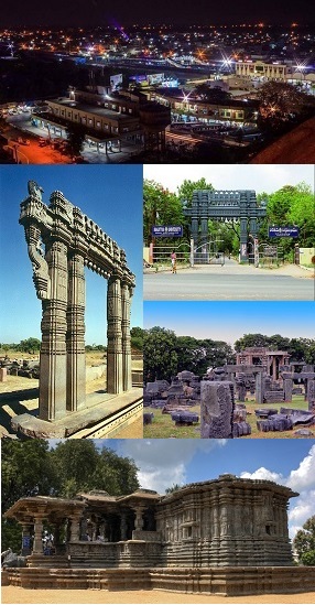
Warangal is a city in the Indian state of Telangana and the district headquarters of Warangal district. It is the second largest city in Telangana with a population of 811,844 per 2011 Census of India, and spreading over an 406 km2 (157 sq mi). Warangal served as the capital of the Kakatiya dynasty which was established in 1163. The monuments left by the Kakatiyas include fortresses, lakes, temples and stone gateways which, in the present, helped the city to become a popular tourist attraction. The Kakatiya Kala Thoranam was included in the emblem of Telangana by the state government and Warangal is also touted as the cultural capital of Telangana.

Jagityala జగిత్యాల is a city in and the district headquarters of Jagtial district of Telangana state, India. Located about 190 kilometres (118 mi) north of the state capital Hyderabad, it has an average elevation of 293 metres (961 ft). In 2011 the population was about 104,000

Nizamabad district is a district located in the north-western region of the Indian state of Telangana. The city of Nizamabad is the district headquarters. The district share boundaries with Jagtial, Sircilla, Nirmal, Kamareddy districts and with Nanded district of the state boundary of Maharashtra.

Hanamkonda district, is a district in the Indian state of Telangana. The district headquarters are located at Hanamakonda. The district borders the districts of Jangaon, Karimnagar, Warangal, Bhupalpally and Siddipet.

Korutla municipality is the second largest town and revenue division in the Jagtial district in the Indian state of Telangana. It is a historical town ruled by Jain Kings and second largest town in Jagtial district. It is the headquarters of Koratla constituency. It is located about 23 kilometres (14 mi) from the district headquarters Jagtial, 235 kilometers from Hyderabad, 73 kilometers from Karimnagar and 76 kilometers from Nizamabad.
National Highway 63 is a National Highway in India, total length 961 km (597 mi). It passes through the states of Maharashtra, Telangana, Maharashtra, Chhattisgarh & Odisha.
Metpally is a town and Revenue Division and third largest town in Jagtial district of the Indian state of Telangana. It is located 222 km away from state capital Hyderabad, 67 km from Nizamabad, 80 km from Karimnagar and 33 km far away from District Headquarter Jagtial. It have great history many Dynasties ruled including Sathavahana's and Kakatiya's. The Kakatiyas built a temple named Chennakesava.
The Diocese of Karimnagar is a diocese of Church of South India in Telangana state of India.The diocese is one among the 22 dioceses of Church of South India.

Northern Power Distribution Company of Telangana Limited, abbreviated as TGNPDCL , is the electricity distribution company owned by the government of Telangana for the 18 northern districts of Telangana with Hanumakonda as the headquarters.

National Highway 61 is a National Highway in India connecting Bhiwandi in Maharashtra to Nirmal in Telangana. The route of this national highway was extended from Nirmal to Jagtial in the state of Telangana. NH-61 runs through states of Maharashtra and Telangana covering a distance of 758 km.
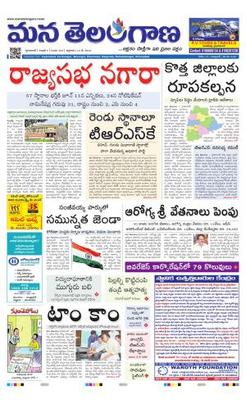
Mana Telangana is a registered Telugu language newspaper in the Indian State of Telangana. It is published simultaneously from Nizamabad, Karimnagar, Warangal, Khammam, Nalgonda, Hyderabad and Mahbubnagar.
Mancherial district is a district located in the northern region of the Indian state of Telangana. The district comprises 18 mandals and two revenue divisions – Mancherial and Bellampalli. The district headquarters is located at Mancherial town. It is surrounded by Komaram Bheem, Nirmal, Jagtial, Peddapalli and Bhupalpally districts of Telangana and with Maharashtra state.

Warangal district, formerly Warangal Rural district, is a district in the Indian state of Telangana. The district shares boundaries with Mahabubabad, Jangaon, Hanamkonda, Mulugu and Bhupalpally districts.
Jagtial district is a district located in the northern region of the Indian state of Telangana. Its administrative headquarters is the city of Jagtial. The district shares boundaries with Nirmal, Mancherial, Karimnagar, Peddapalli, Sircilla and Nizamabad districts.
National Highway 365A, commonly called NH 365A is a national highway in India. It is a spur road of National Highway 65. NH-365A traverses the state of Telangana in India.
National Highway 365BB is a national highway in India. It is a secondary route of National Highway 65. NH-365BB traverses the states of Telangana and Andhra Pradesh in India. It starts at Suryapet and ends at Kovvur(Rajamahendravaram).Major cities on this route are Suryapet, Khammam and Rajamahendravaram.

Vijayawada–Hyderabad Expressway is a 247 km long, 4/6 lane wide tolled expressway that connects Vijayawada in Andhra Pradesh with Hyderabad in Telangana. It was opened for public in October 2012. The project was undertaken by concessionaire GMR Hyderabad Vijayawada Expressways Private Limited, a subsidiary of GMR Group on a Build-Own-Operate-Transfer (BOOT) basis. It is one of the busiest expressways in India and is a part of National Highway 65, which connects Machilipatnam to Pune.

The Karimnagar Cable Bridge is a cable-stayed bridge in Karimnagar, Telangana, India. The bridge is located near the outskirts of Karimnagar town and is part of the National Highway 563 route.


