 | ||||
|---|---|---|---|---|
 NH 148N in red | ||||
| Route information | ||||
| Length | 59.625 km (37.049 mi) | |||
| Major junctions | ||||
| North end | ||||
| South end | ||||
| Location | ||||
| Country | India | |||
| States | Rajasthan | |||
| Highway system | ||||
| ||||
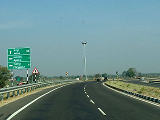
National Highway 148N (NH 148N) is a National Highway in India. [1] [2] [3]
| | ||||
|---|---|---|---|---|
| NH 148N in red | ||||
| Route information | ||||
| Length | 59.625 km (37.049 mi) | |||
| Major junctions | ||||
| North end | ||||
| South end | ||||
| Location | ||||
| Country | India | |||
| States | Rajasthan | |||
| Highway system | ||||
| ||||
National Highway 148N (NH 148N) is a National Highway in India. [1] [2] [3]

The Golden Quadrilateral is a national highway network connecting several major industrial, agricultural and cultural centres of India. It forms a quadrilateral with all the four major metro cities of India forming the vertices, viz., Delhi (north), Kolkata (east), Mumbai (west) and Chennai (south). Other major cities connected by this network include Ahmedabad, Bengaluru, Balasore, Bhadrak, Bhubaneswar, Cuttack, Berhampur, Durgapur, Faridabad, Guntur, Gurugram, Jaipur, Kanpur, Pune, Kolhapur, Surat, Vijayawada, Eluru, Ajmer, Visakhapatnam, Bodhgaya, Varanasi, Prayagraj, Agra, Mathura, Dhanbad, Gandhinagar, Udaipur, and Vadodara. The main objective of these super highways is to reduce the travel time between the major cities of India, running roughly along the perimeter of the country. The North–South corridor linking Srinagar and Kanyakumari, and East–West corridor linking Silchar (Assam) and Porbandar (Gujarat) are additional projects. These highway projects are implemented by the National Highway Authority Of India (NHAI). At 5,846 kilometres (3,633 mi), it is the largest highway project in India and the fifth longest in the world. It is the first phase of the National Highways Development Project (NHDP), and consists of two, four, and six-lane express highways, built at a cost of ₹600 billion (US$7.5 billion). The project was planned in 1999, launched in 2001, and was completed in 7 January 2012.

Roads in India are an important mode of transport in India. India has a network of over 6,331,791 kilometres (3,934,393 mi) of roads. This is the second-largest road network in the world, after the United States. At of roads per square kilometre of land, the quantitative density of India's road network is equal to that of Hong Kong, and substantially higher than the United States, China, Brazil and Russia. Adjusted for its large population, India has approximately 5.13 kilometres (3.19 mi) of roads per 1,000 people, which is much lower than United States 20.5 kilometres (12.7 mi) but higher than that of China 3.6 kilometres (2.2 mi). India's road network carries over 71% of its freight and about 85% of passenger traffic.

The North–South–East–West r (NS-EW) is the largest ongoing highway project in India. It is the second phase of the National Highways Development Project (NHDP), and consists of building 7300 kilometers of four/six lane highways associating Srinagar, Kanyakumari, Kochi, Porbandar and Silchar, at a cost of US$12.317 billion ₹1000000000000(One lakh Crore INR). As of 19 March 2024, 6875 of the 7142 kilometers project has been finished.

The National Highways Development Project (NHDP) was a project of four laning of existing national highways and six laning of selected major national highways of India. The project was started in 1998 under the leadership of Prime Minister, Atal Bihari Vajpayee. National Highways account for only about 2% of the total length of roads, but carry about 40% of the total traffic across the length and breadth of the country. This project is managed by the National Highways Authority of India (NHAI) under the Ministry of Road, Transport and Highways. The NHDP represents 49,260 km of roads and highways work and construction in order to boost economic development of the country. The government has planned to end the NHDP program in early 2018 and subsume the ongoing projects under a larger Bharatmala project.

Maradu is a municipality in the Ernakulam district of Kerala, India. Maradu is located 6.1 km (3.8 mi) east of the Kochi city centre, and is a part of the Kochi metropolitan area. Maradu is an inner suburb of Kochi, located immediately south of Vyttila and connected to Thevara in the west by the Kundanoor bypass. National highways NH 85, NH 966 B and NH 66 passes through Maradu and has played a vital role in the development of the area.

Kerala, a state in Southern India, has a network of 11 National Highways, 72 State Highways and many district roads.
Expressways are the highest class of roads in India. In July 2023, the total length of expressways in India was 5,579 km (3,467 mi), with 8,366 km (5,198 mi) under construction. These are controlled-access highways where entrance and exits are controlled by the use of cloverleaf or trumpet or grade separated interchanges that are incorporated into the design of the expressway and designed for maximum speed of 120 km/h, whereas National highways are flyover access or tolled, where entrance and exit is through the side of the flyover, at each intersection of highway with road, flyovers are provided to bypass the city/town/village traffic and these highways are designed for speed of 100 km/h. Some roads are not access-controlled expressways but are still named expressways, such as the Biju Expressway, these are actually state highways that are not declared by the central government as an Expressway, hence not an Expressway or National Highway.
In India, this is the network of roads maintained by the state governments. These roads are constructed and managed by the states' Public Works Department. The state highways are usually roads that link important cities, towns and district headquarters within the state and connect them with National Highways or state highways of neighbouring states.
State Highway 2 is a State Highway in Kerala, India that starts from Thiruvananthapuram Peroorkada and ends near Thenmala Kollam by joining with Kollam-Tirumangalam NH-744. The highway is 73.2 km long. The major towns in this highway are Nedumangad, Palode and Kulathupuzha.
Kundannoor is a region in the city of Kochi, in the state of Kerala, India. It is located around 3.5 km from Vytilla Junction and around 7 km from Ernakulam Junction Railway Station. Kundanoor is located on the busiest road of the city and state, the Kochi Bypass, at the junction of three National Highways, namely NH 66, NH 85 and NH 966B. NH 966B is the second shortest National highway in India.
The Regional Ring Road is a proposed ring road around the city of Hyderabad, Telangana, India. It is a 4 lane, 340-kilometre-long (210 mi) road, planned on strengthening the existing road network and by adding new stretches wherever linkages were found missing. National Highways Authority of India has included Regional Ring road in the pan-India Bharatmala Pariyojana Phase-2. It helps connect the districts around city of Hyderabad. It helps in linking major national highways like NH 65, NH 44, NH 163, NH 765.
The Bharatmala Pariyojna is an ongoing project that will interconnect 550 District Headquarters through a minimum 4-lane highway by raising the number of corridors to 50 and move 80% freight traffic to National Highways by interconnecting 24 logistics parks, 66 inter-corridors (IC) of total 8,000 km (5,000 mi), 116 feeder routes (FR) of total 7,500 km (4,700 mi) and 7 north east Multi-Modal waterway ports. The project also includes development of tunnels, bridges, elevated corridors, flyovers, overpass, interchanges, bypasses, ring roads etc. to provide shortest, jam free & optimized connectivity to multiple places, it is a centrally-sponsored and funded Road and Highways project of the Government of India. This ambitious umbrella programme will subsume all existing Highway Projects including the flagship National Highways Development Project (NHDP), launched by the Atal Bihari Vajpayee government in 1998. Bharatmala is mainly focused on connecting remote areas and satellite cities of megacities such as Bengaluru, Pune, Hyderabad etc. The total investment for 83,677 km (51,994 mi) committed new highways is estimated at ₹10.63 lakh crore (US$130 billion), making it the single largest outlay for a government road construction scheme. The project will build highways from Maharashtra, Gujarat, Rajasthan, Punjab, Haryana and then cover the entire string of Himalayan territories - Jammu and Kashmir, Himachal Pradesh, Uttarakhand - and then portions of borders of Uttar Pradesh and Bihar alongside Terai, and move to West Bengal, Sikkim, Assam, Arunachal Pradesh, and right up to the Indo-Myanmar border in Manipur and Mizoram. Special emphasis will be given on providing connectivity to far-flung border and rural areas including the tribal and backward areas.
Setu Bharatam was launched by Prime Minister Narendra Modi on 4 March 2016 at a budget of ₹102 billion (US$1.3 billion), with an aim to make all national highways free of railway crossings by 2019.
National Highway 23 is a primary national highway in India. NH-23 runs in an east-west direction, entirely in the state of Rajasthan.
National Highway 70, commonly referred to as NH 70 is a primary national highway in India. NH-70 traverses the state of Rajasthan in India. It is part of Bharatmala pariyojana.
National Highway 717A, commonly referred to as NH 717A is a National Highway in India which is a part of the Bharatmala Pariyojana of Ministry of Road Transport and Highways, Government of India. NH 717-A starts from National Highway 17 at Bagrakote and ends in Gangtok. NH-717A traverses the states of West Bengal and Sikkim in India. It runs through two districts of West Bengal namely Jalpaiguri district, Kalimpong district and two districts of Sikkim, which are Pakyong District and Gangtok District. The highway is being constructed and maintained by the National Highways and Infrastructure Development Corporation Limited (NHIDCL).
National Highway 179A, commonly referred to as NH 179A, is a national highway in India, which comes under Ministry of Road Transport & Highways, Government of India. It is a secondary route of National Highway 79. NH-179A traverses the state of Tamil Nadu in India.
National Highway 365BB is a national highway in India. It is a secondary route of National Highway 65. NH-365BB traverses the states of Telangana and Andhra Pradesh in India. It starts at Suryapet and ends at Kovvur(Rajamahendravaram).Major cities on this route are Suryapet, Khammam and Rajamahendravaram.
National Highway 354, commonly referred to as NH 354 is a national highway in India. It is a spur road of National Highway 54 under Bharatmala in the state of Panjab in India.

National Highway 109K, commonly referred to as NH 109K, is a National highway connecting the city of Simli to Jauljibi in the Indian State of Uttarakhand. The Highway was Notified on 12 Feb 2021 under the Bharatmala project of Government of India.
Secondary routes of National Highway 48 | ||
|---|---|---|
| |  | |
| Secondary Routes of NH 48 | ||


