
Ooty, abbreviated as Udagai) is a town and municipality in the Nilgiris district of the Indian state of Tamil Nadu. It is located 86 km (53 mi) northwest of Coimbatore, and is the headquarters of Nilgiris district. Situated in the Nilgiri hills, it is known by the epithet "Queen of Hill Stations", and is a popular tourist destination.

Chamarajanagar or Chamarajanagara is the southernmost district in the state of Karnataka, India. It was carved out of the original larger Mysore District in 1998. Chamarajanagar town is the headquarters of this district.

Bandipur National Park is a national park covering 868.63 km2 (335.38 sq mi) in Chamarajnagar district in the Indian state of Karnataka. It was established as a tiger reserve under Project Tiger in 1973. It is part of the Nilgiri Biosphere Reserve since 1986.

Kollegala is the Major taluk in the Chamarajanagara District of Karnataka State in the south of India. Kollegala is well known for its silk industry which attracts traders from all over the state.
Gundlupet is a municipal town situated in the Chamarajanagar district of Karnataka, India. It is also known as "The flower pot of India". It is situated on NH 766, 60 km away from Mysuru and approximately 200 km from the state administrative capital, Bengaluru. Gundlupet is the last town in Karnataka on the National Highway 766 which goes through Mysore, Ooty, Wayanad, and Kozhikode. It is situated very close to the Tamil Nadu and Kerala state borders. NH 181 begins from Gundlupet and ends in Nagapattinam in Tamil Nadu via Ooty and Coimbatore.
Mettupalayam is a municipality town and Taluk headquarters of Mettupalayam Taluk in the Coimbatore district of the Indian state of Tamil Nadu, a suburb of Coimbatore. It is the second largest town in the Coimbatore district after Pollachi. It is located to the north of Coimbatore city on the way to Ooty, in the foothills of Nilgiri hills. As of 2011, the town had a population of 69,213. Mettupalayam railway station is the starting point of Nilgiri Mountain Railway and it operates the only rack railway in India connecting Ooty and Mettupalayam.
Narasimhanaickenpalayam is a part of Coimbatore city. It is about 14 km from Coimbatore city junction in the northern direction. Narasimhanaickenpalayam is on the stretch of National Highway NH 67 Extn (NH-181) Mettupalayam Road, one of the arterial roads of Coimbatore city. Neighbouring places are Thudiyalur, NGGO Colony, and Periyanaickenpalayam

Many Ghat Roads can be found in the Nilgiris District of Tamil Nadu, Southern India. Nearly all of the district is located in the Nilgiri Hills, part of the Western Ghats mountains. This area borders the states of Karnataka and Kerala. The hills consequently can be reached by road from three states. Most of these Ghat Roads go through heavily forested mountains and contain a number of sharp hair-pin bends.
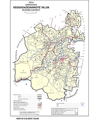
Sargur, is a small town located about 80 km from the town of Chamarajanagar And a Taluk of Mysore district of Karnataka, India. H D Kote (Heggadadevanakote) is about 12 km north of Sargur. It is 55 km from the city of Mysore. Bangalore International Airport is 200 km away. To be more elaborate, Sargur is 33.8 km from Nanjangud town (Karnataka), 35.1 km from Gundlupet town (Karnataka), 137.8 km from Udagamandalam town (Ooty) Valley and 38.8 km from Hunsur town (Karnataka).
Nilambur–Nanjangud line also called The golden I. T. corridor or Wayanad Railway, is a railway project to create a 5 ft 6in broad gauge rail connection from the town of Nanjangud (Karnataka) to Nilambur (Kerala) through Wayanad district of Kerala and Nilgiri district of Tamil Nadu.

Thanjavur has a well-developed transport infrastructure. Thanjavur is well connected by Road, and Rail with most cities and towns in India

National Highway 544, commonly referred to as NH 544, is a 340-kilometre-long (210 mi) National Highway in South India connecting Salem city in Tamil Nadu to the city of Kochi in Kerala. It is also called the Salem-Kochi Highway. The highway runs through the states of Kerala and Tamil Nadu, connecting various important cities and towns such as Salem, Erode, Coimbatore, Palakkad, Thrissur and Kochi. It is a spur of National Highway 44, which forms the North South Corridor of the National Highway network of India.It passes south of Coimbatore. NH544 is the only highway in kerala which is fully 4lane including kuthiran Road Tunnel. It was formerly designated National Highway 47.
Coimbatore is a city in the state of Tamil Nadu, India. Most transportation in the city and suburbs is by road. Coimbatore is well-connected to most cities and towns in India by road, rail, and air, but not through waterways. The city has successful transport infrastructure compared to other Indian cities, though road infrastructures are not well maintained and developed according to the growing needs of transport, making traffic congestion a major problem in the city. A comprehensive transport development plan has been made to address many traffic problems.

National Highway 766 is a National Highway in Southern India. NH 766 connects Kozhikode in Kerala with Kollegal in Karnataka via Mysore. Of the total distance of 272 km, 117 km is in Kerala and 155 is in Karnataka. At Kollegal, it joins National Highway 948, which connects Bengaluru and Coimbatore. The highway passes through dense forests of Western ghats of India. The NH-766 passes through 19.7 km Bandipur National Park and Wayanad wild life sanctuary.
Mettupalayam Road, (NH 181) is a major arterial road in city of Coimbatore, Tamil Nadu, India. This NH runs for about 10 kilometers starting exactly from Rangai Gownder street up to the northern Thudiyalur within the corporation limits.Beyond that the road continues northwards for a distance of 26 kilometres till Mettupalayam. It is six metres (20 ft) wide in most stretches. The road narrows at the stretches between Edayar street, RG street and Flower Market areas. Green Corridor system is under implementation between Chintamani and Thudiyalur to synchronise traffic signals, as it is one of the most congested stretches in the city. This road connects the city with Saibaba Colony Bus Terminus and the northern suburbs in the Coimbatore Metropolitan Area.
National Highway 948 is a highway in India which connects Coimbatore in Tamil Nadu with the city of Bengaluru. It is a spur road of National Highway 48. It passes through Sathyamangalam Wildlife Sanctuary. The road through the wildlife sanctuary is a single carriageway with two lanes, and it is narrow at many places. Wild animals can be spotted in this route. The movement of automobiles are not allowed from 8 P.M to 6 A.M through Dhimbam ghat stretch in this national highway. National Highway 948 passes through Sathyamangalam forests, which were the territory of the bandit Veerappan.

The district capital of Wayanad is Kalpetta town. Kalpetta has very good road connectivity with the rest of Kerala and neighboring South Indian cities. National Highway 766 (India) NH766 connects Kalpetta with Kozhikode and Mysore. State Highways connect Kalpetta with Ooty in Tamil Nadu and Madikeri in Karnataka.
National Highway 81, commonly referred to as NH 81, is a highway connecting the city of Coimbatore to Chidambaram in South India. This highway was previously part of old national highways 67 and 227 but subsequent to rationalisation of national highway numbers of India by Gazette notification on 5 March 2010 it was changed to National Highway 81. This national highway is 321.4 km (199.7 mi) long and runs entirely in the Indian state of Tamil Nadu.

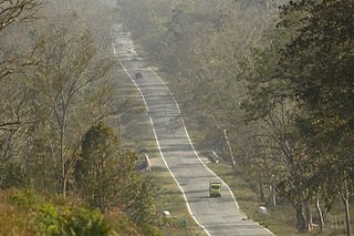
Mysore-Ooty Road or Mysore-Udhagamandalam Road is a tourist trail of South India starting from Mysore in Karnataka state and ending in Udhagamandalam in Nilgiri district of Tamil Nadu state, India. Both routes pass through Bandipur National park in Gundlupet, Karnataka and Mudumalai National Park in Tamil Nadu.

In February 2019, major forest fires broke out in numerous places across the Bandipur National Park in Karnataka state in India. The National Remote Sensing Centre of the Indian Space Research Organisation (ISRO) carried out an assessment of the total area affected by the fire. On 25 February 2019, it estimated the extent of burnt area to be about 10,920 acres in the last five days from 21 February 2019.


