Mysore-Ooty Road

Last updated

Mysore-Ooty Road
Route information
Length158 km (98 mi)
Existed1799–present
Major junctions
From Mysore, Karnataka
Major intersectionsGundlupet
East end Udhagamandalam, Tamil Nadu
Location
Country India
States Tamil Nadu, Karnataka
Major cities Gudalur
Highway system

Mysore-Ooty Road or Mysore-Udhagamandalam Road is a tourist trail of South India starting from Mysore in Karnataka state and ending in Udhagamandalam in Nilgiri district of Tamil Nadu state, India. Both routes pass through Bandipur National park in Gundlupet, Karnataka and Mudumalai National Park in Tamil Nadu.

Contents

Karnataka Tamil Nadu Border Bandipur.Karnataka Tamilnadu Border.jpg
Karnataka Tamil Nadu Border

At the crossing there are statues of a tiger, a leopard, a gaur, a deer and an elephant.

Distance

Ooty is well connected by roads. It is 260 km (172 mi) from Bangalore, 598 km (372 mi) from Chennai [3] (via Salem, Erode, and Coimbatore), 80 km (50 mi) from Coimbatore and 124 km (77 mi) from Mysore. [4] Ooty is situated on NH 181 and is connected by road via the five main accepted Nilgiri Ghat Roads. Bus services operated by TNSTC and KSRTC connect major towns in the state and nearby towns in the district such as Coonoor, Kotagiri, and Gudalur, Mysore and Gundlupet.

Bandipur National Park

Bandipur National Park (Kannada : ಬಂಡೀಪುರ ರಾಷ್ಟ್ರೀಯ ಉದ್ಯಾನ) established in 1974 as a tiger reserve under Project Tiger, is a national park located in the south Indian state of Karnataka. It was once a private hunting reserve for the Maharaja of the Kingdom of Mysore but has now been upgraded to Bandipur Tiger Reserve. [5] Bandipur is known for its wildlife and has many types of biomes, but dry deciduous forest is dominant.

The park spans an area of 874 square kilometers (337 sq mi), protecting several species of India's endangered wildlife. Together with the adjoining Nagarhole National Park (643 km2 (248 sq mi)), Mudumalai National Park (320 km2 (120 sq mi)) and Wayanad Wildlife Sanctuary (344 km2 (133 sq mi)), it is part of the Nilgiri Biosphere Reserve totaling 2,183 km2 (843 sq mi) making it the largest protected area in southern India and largest habitate of wild elephants in south Asia. Bandipur is located in Gundlupet taluq of Chamarajanagar district. It is about 80 kilometers (50 mi) from the city of Mysore on the route to a major tourist destination of Ooty. [6] As a result, Bandipur sees a lot of tourist traffic and there are many wildlife fatalities caused by speeding vehicles that are reported each year. [7] There is a ban on traffic from 9 pm to 6 am of dusk to dawn to help bring down the death rate of wildlife. [8]

Mudumalai National Park

The Mudumalai National Park and Wildlife Sanctuary (Tamil:முதுமலை தேசிய பூங்கா மற்றும் விலங்குகள் சரணாலயம்) also a declared tiger reserve, lies on the northwestern side of the Nilgiri Hills (Blue Mountains), in Nilgiri District, about 150 kilometres (93 mi) north-west of Coimbatore city in Kongu Nadu region of Tamil Nadu. It shares its boundaries with the states of Karnataka and Kerala. The sanctuary is divided into five ranges – Masinagudi, Thepakadu, Mudumalai, Kargudi and Nellakota.

The protected area is home to several endangered and vulnerable species including Indian elephant, Bengal tiger, gaur and Indian leopard. There are at least 266 species of birds in the sanctuary, including critically endangered Indian white-rumped vulture and long-billed vulture. [9]

Mudumalai tiger reserve Masinagudi - mudumalai.jpg
Mudumalai tiger reserve

The Western Ghats Nilgiri Sub-Cluster of 6,000 square kilometres (2,300 sq mi), including all of Mudumalai National Park, is under consideration by the UNESCO World Heritage Committee for selection as a World Heritage Site. [10]

The driving experience

Mysore to Nanjangud

The road in this sector is two track with a toll booth in the middle. The major tourist attraction is the S.G.S.Ashram with an aviary, library and museum inside. There are good restaurants like Rhythm.n.Hues, The Evergreen, the Grand View and Vishnu Cafe before reaching the airport. This is a very silent airport as no flights are operational now. Before airport there is a scenic place with a lake and bend in the road. After Kadakola town, there are two Punjabi dhabha restaurants offering private outdoor huts. There is a riverside temple at Sujathapuram and also India's oldest railway bridge is located here. Cafe Coffee Day has an outlet here. Royal Hotel provides Kerala style food. Nanjangud town has many lodges and restaurants.

Nanjangud to Gundlupet

This stretch also has two way road without any toll. There are some beautiful churches and temples on this way. Many Kerala restaurants dot either side of the road. There is a drive-in-cafe 15 km from Nanjangud. There is an outlet of Cafe Coffee Day another ten kilometer forward.

Gundlupet to Gudalur

This is a single line track passing through two national parks. You can find humps every 300 meters and the driving is very unpleasant. Night traffic is banned and animal sightings are rare during daytime except for elephants and deer.

Gudalur to Ooty

This is a very scenic uphill route but traffic blocks are very common near the Frog Hill viewpoint. They last for one or two hours. The two sides of the road are very scenic with shola forests, undulating hills and lakes.

Related Research Articles

<span class="mw-page-title-main">Chamarajanagar district</span> District of Karnataka in India

Chamarajanagar or Chamarajanagara is the southernmost district in the state of Karnataka, India. It was carved out of the original larger Mysore District in 1998. Chamarajanagar town is the headquarters of this district.

<span class="mw-page-title-main">Nilgiris district</span> District in Tamil Nadu, India

The Nilgiris district is one of the 38 districts in the southern Indian state of Tamil Nadu. Nilgiri is the name given to a range of mountains spread across the borders among the states of Tamil Nadu, Karnataka and Kerala. The Nilgiri Hills are part of a larger mountain chain known as the Western Ghats. Their highest point is the mountain of Doddabetta, height 2,637 m. The district is contained mainly within the Nilgiri Mountains range. The administrative headquarters is located at Ooty. The district is bounded by Coimbatore to the south, Erode to the east, and Chamarajnagar district of Karnataka and Wayanad district of Kerala to the north. As it is located at the junction of three states, namely, Tamil Nadu, Kerala, and Karnataka, significant Malayali and Kannadiga populations reside in the district. Nilgiris district is known for natural mines of Gold, which is also seen in the other parts of Nilgiri Biosphere Reserve extended in the neighbouring states of Karnataka and Kerala too.

<span class="mw-page-title-main">Bandipur National Park</span> National park in Karnataka, India

Bandipur National Park is a national park covering 868.63 km2 (335.38 sq mi) in Chamarajnagar district in the Indian state of Karnataka. It was established as a tiger reserve under Project Tiger in 1973. It is part of the Nilgiri Biosphere Reserve since 1986.

<span class="mw-page-title-main">South Western Ghats moist deciduous forests</span> Ecoregion in India

The South Western Ghats moist deciduous forests is an ecoregion in the Western Ghats of southern India with tropical and subtropical moist broadleaf forests. This biome covers the Nilgiri Hills between elevation of 250 and 1,000 m in Kerala, Karnataka and Tamil Nadu states.

<span class="mw-page-title-main">Mudumalai National Park</span> National park in Tamil Nadu, India

Mudumalai National Park is a national park in the Nilgiri Mountains in Tamil Nadu in southern India. It covers 321 km2 (124 sq mi) at an elevation range of 850–1,250 m (2,790–4,100 ft) in the Nilgiri District and shares boundaries with the states of Karnataka and Kerala. A part of this area has been protected since 1940. The national park has been part of Nilgiri Biosphere Reserve since 1986 and was declared a tiger reserve together with a buffer zone of 367.59 km2 (141.93 sq mi) in 2007. It receives an annual rainfall of about 1,420 mm (56 in) and harbours tropical and subtropical moist broadleaf forests with 498 plant species, at least 266 bird species, 18 carnivore and 10 herbivore species. It is drained by the Moyar River and several tributaries, which harbour 38 fish species.

<span class="mw-page-title-main">Gundlupet</span> Town in Karnataka, India

Gundlupet is a municipal town situated in the Chamarajanagar district of Karnataka, India. It is also known as "The flower pot of India". It is situated on NH 766, 60 km away from Mysuru and approximately 200 km from the state administrative capital, Bengaluru. Gundlupet is the last town in Karnataka on the National Highway 766 which goes through Mysore, Ooty, Wayanad, and Kozhikode. It is situated very close to the Tamil Nadu and Kerala state borders. NH 181 begins from Gundlupet and ends in Nagapattinam in Tamil Nadu via Ooty and Coimbatore.

<span class="mw-page-title-main">Nilgiri Ghat Roads</span>

Many Ghat Roads can be found in the Nilgiris District of Tamil Nadu, Southern India. Nearly all of the district is located in the Nilgiri Hills, part of the Western Ghats mountains. This area borders the states of Karnataka and Kerala. The hills consequently can be reached by road from three states. Most of these Ghat Roads go through heavily forested mountains and contain a number of sharp hair-pin bends.

<span class="mw-page-title-main">Nilgiri Mountains</span> Mountain range in Tamil Nadu, India

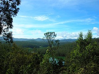
The Nilgiri Mountains form a part of the Western Ghats in northwestern Tamil Nadu, southern Karnataka and eastern Kerala in South India. They are located at the trijunction of the three states and connect the Western Ghats to the Eastern Ghats. At least 24 of the Nilgiri Mountains' peaks are above 2,000 m (6,600 ft), with the highest peak being Doddabetta at 2,637 m (8,652 ft).

<span class="mw-page-title-main">Sargur</span> Town in Karnataka, India

Sargur, is a small town located about 80 km from the town of Chamarajanagar And a Taluk of Mysore district of Karnataka, India. H D Kote (Heggadadevanakote) is about 12 km north of Sargur. It is 55 km from the city of Mysore. Bangalore International Airport is 200 km away. To be more elaborate, Sargur is 33.8 km from Nanjangud town (Karnataka), 35.1 km from Gundlupet town (Karnataka), 137.8 km from Udagamandalam town (Ooty) Valley and 38.8 km from Hunsur town (Karnataka).

<span class="mw-page-title-main">Geography of South India</span>

The Geography of South India comprises the diverse topological and climatic patterns of South India. South India is a peninsula in the shape of a vast inverted triangle, bounded on the west by the Arabian Sea, on the east by the Bay of Bengal and on the north by the Vindhya and Satpura ranges.

Nilambur–Nanjangud line also called The golden I. T. corridor or Wayanad Railway, was a railway project to create a 5 ft 6in broad gauge rail connection from the town of Nanjangud (Karnataka) to Nilambur (Kerala) through Wayanad district of Kerala and Nilgiri district of Tamil Nadu.

<span class="mw-page-title-main">Sathyamangalam Tiger Reserve</span> Tiger Reserve in Tamil Nadu, India

Sathyamangalam Tiger Reserve is a protected area and tiger reserve located along the area straddling both the Western Ghats and Eastern Ghats in the Erode district of the Indian state of Tamil Nadu. The Sathyamangalam Forest Division is part of the Bramhagiri-Nilgiris-Eastern Ghats Elephant Reserve notified in 2003. In 2008, part of the Sathyamangalam Forest Division was declared a wildlife sanctuary, which was further enlarged in 2011 to cover a forest area of 1,411.6 km2 (545.0 sq mi). It is the largest wildlife sanctuary in Tamil Nadu. In 2013, an area of 1,408.6 km2 (543.9 sq mi) of the erstwhile sanctuary was notified as a tiger reserve and it was the fourth tiger reserve established in the state as a part of Project Tiger.

<span class="mw-page-title-main">Sigur Plateau</span> Reserve forest in Tamil Nadu, India

Sigur Plateau is a plateau in the north and east of Nilgiri District in the Nilgiri Hills of Tamil Nadu, South India. It covers the 778.8 square kilometres (300.7 sq mi) portion of the Moyar River drainage basin on the northern slopes of the Nilgiri Hills, south of the Moyar River.

<span class="mw-page-title-main">National Highway 766 (India)</span> National highway in India

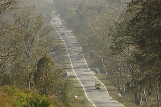
National Highway 766 is a National Highway in Southern India. NH 766 connects Kozhikode in Kerala with Kollegal in Karnataka via Mysore. Of the total distance of 272 km, 117 km is in Kerala and 155 is in Karnataka. At Kollegal, it joins National Highway 948, which connects Bengaluru and Coimbatore. The highway passes through dense forests of Western ghats of India. The NH-766 passes through 19.7 km Bandipur National Park and Wayanad wild life sanctuary.

<span class="mw-page-title-main">Outline of Tamil Nadu</span> Overview of and topical guide to Tamil Nadu

The following outline is provided as an overview of and topical guide to Tamil Nadu:

<span class="mw-page-title-main">Theppakadu</span> Place in Tamil Nadu, India

Theppakadu is a village in the Nilgiris district in the Indian state of Tamil Nadu. As per Census 2011, it is part of the Mudumalai village which covers 188.57 km2 (72.81 sq mi) and had a population of 1,694 persons in 2011. It has a reserve forest which is part of the Mudumalai National Park in western Tamil Nadu touching the south of Karnataka. Theppakadu is 240 km (150 mi) from Bangalore, via Mysore through SH17 and NH 212.

National Highway 181, commonly referred to as NH 181, is a highway connecting the city of Coimbatore in Tamil Nadu to Gundlupete in Karnataka state, South India. The city of Mysuru is connected to Ooty by road via Nanjanagudu, Gundlupete, Bandipur and Gudalur. The national highway 181 passes through Bandipur Tiger Reserve and Mudumalai Tiger Reserve, hence vehicular traffic is restricted at night from 9 p.m to 6 a.m. Wild animals like elephants, bison, bears, tiger, and leopards can be spotted sometimes on this highway in the tiger reserve stretches. NH 181 after Ooty goes to Coonoor, Mettupalayam, Karamadai and ends in Coimbatore city.

<span class="mw-page-title-main">Transportation in Wayanad</span>

The district capital of Wayanad is Kalpetta town. Kalpetta has very good road connectivity with the rest of Kerala and neighboring South Indian cities. National Highway 766 (India) NH766 connects Kalpetta with Kozhikode and Mysore. State Highways connect Kalpetta with Ooty in Tamil Nadu and Madikeri in Karnataka.

<span class="mw-page-title-main">Nilambur Elephant Reserve</span> Elephant reserve in India

Nilambur Elephant Reserve is a wildlife reserve in Kerala, India. It has a total area of 1419 (sq. km2) and was created in 2002 as part of Project Elephant. The reserve is one of four in Kerala; the state having an elephant population of 5706 in 2018.

References

  1. "Mysore to Ooty Routes".
  2. SOSTravelHouse.com. "Mysore Ooty Coorg Tour Package". www.SOSTravelHouse.com. Archived from the original on 17 June 2024. Retrieved 17 June 2024.
  3. "How to Reach Ooty". Mistair Realty. Archived from the original on 4 August 2013. Retrieved 6 August 2013.
  4. "Bandipur". mysore.ind.in. Retrieved 13 January 2013.
  5. "Bandipur National park". Mysore.nic.in. Retrieved 8 October 2012.
  6. "Bandipur". mysore.ind.in. Retrieved 13 January 2013.
  7. "Taming traffic in Bandipur National Park". Wildlifetrustofindia.org. Archived from the original on 17 December 2012. Retrieved 8 October 2012.
  8. "Night traffic ban at Bandipur extended from 9 to 12 hours". Deccanherlad.com. Retrieved 8 October 2012.
  9. "Mudumalai Wildlife Sanctuary". Conservation database. Bangalore: Ashoka Trust for Research in Ecology and the Environment Eco-Informatics Centre. Archived from the original on 24 December 2009. Retrieved 9 November 2009.
  10. UNESCO, World Heritage sites, Tentative lists, Western Ghats sub cluster, Ooty. retrieved 20 April 2007 World Heritage sites, Tentative lists