
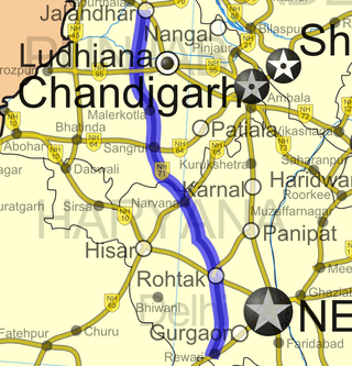
National Highway 8 is a 4-lane National Highway in India. According to estimates, it is the busiest highway in the subcontinent, as it connects the national capital Delhi to the financial capital Mumbai, as well as important cities Gurgaon, Jaipur, Ajmer, Udaipur, Ahmedabad, Vadodara, Surat, Nadiad, Anand and Kheda. The total length is 1428km. Under the new numbering it has become part of the NH48.
Pataudi is a town, a tehsil and one of the 4 sub-divisions of Gurugram district, in the Indian state of Haryana, within the boundaries of the National Capital Region of India. It is located 28 km (17.4 mi) southwest of Gurugram city.
Rewari is a city and a municipal council in Rewari district in the Indian state of Haryana. It is district headquarter of Rewari district. It is located in south-west Haryana around 82 km from Delhi and 51 km from Gurgaon. It lies in Ahirwal region.
Delhi, a major metropolitan region of India, is connected to various parts of country through several national highways and expressways. All the highways and expressways from Delhi lead to Haryana or Uttar Pradesh and continue from there.
The Western Peripheral Expressway (WPE) or Kundli–Manesar–Palwal Expressway, is an operational 6-lane, 135.6 km (84.3 mi)-long Expressway in the Haryana state of India. Along with the Eastern Peripheral Expressway, the Western Peripheral Expressway is expected to divert more than 50,000 heavy vehicles away from Delhi, which will help to maintain good air quality in Delhi. Western Peripheral Expressway along with Eastern Peripheral Expressway completes the largest Ring Road around Delhi. There are 10 tolled entries and exits, from north to south - Kundli, Kharkhoda, Bahadurgarh, Badli, Fartukhnagar, Panchgaon, Manesar, Taoru, Sohna & Palwal. Toll rate notified in December 2018 is INR1.35 per km for cars, INR2.18 per km for light motor vehicles, INR4.98 per km for trucks and buses, and two wheelers are not permitted on the expressway.
National Highway 11 or NH 11 is a National Highway in India that links Jaisalmer (Rajasthan) and Rewari (Haryana). This 848 km-long highway passes through Myajlar, Pithala, Jaisalmer, Pokaran, Ramdevara, Phalodi, Bap, Diyatra Gajner, Bikaner, Sri Dungargarh, Rajaldesar, Ratangarh, Rolsabsar, Fatehpur, Tajsar, Mandawa, Jhunjhunu, Bagar, Chirawa, Singhana, Pacheri, Narnaul, Ateli and Rewari.
National Highway 71 was a National Highway in Northern India. NH 71 connected Jalandhar in Punjab to Rewari in Haryana, running a distance of 307 km (191 mi). It ran for a distance of 130 km (81 mi) in Punjab and 177 km (110 mi) in Haryana. National Highway 71 started at the junction of old NH 1 at Jalandhar and traverses down to Rewari to meet old NH 8.
Northern Peripheral Road or NH 248-BB, commonly known as Dwarka Expressway is a 27.6 km (17.1 mi) long, under construction, 8-lane(elevated) and 8-lane(service road), total 16-lane elevated grade separated expressway connecting Dwarka in Delhi to Kherki Daula Toll Plaza, Gurgaon in Haryana. The expressway will take off from km 20 of NH 48 at Shiv Murti in Mahipalpur in Delhi and terminate at km 40 of NH 48 near Kherki Daula Toll Plaza in Gurgaon in Haryana. The NPR has been planned as an alternate road link between Delhi and Gurgaon, and is expected to ease the traffic situation on the Delhi-Gurgaon Expressway. The expressway was initially planned to be 18 km (11 mi) long and was expected to open by 2012 but land acquisition issues delayed the project.
New Gurgaon is a planned city situated in the state of Haryana in India. The two main clusters in New Gurgaon along the upcoming Dwarka-Gurgaon Expressway are Sectors 102 to 113 and Sectors 76 to 95 95A, Sector 83 and Sector 83. New Gurgaon is well connected with three highways, NH48, Kundli–Manesar–Palwal Expressway and Dwarka-Gurgaon Expressway, Railway Station, Airport, and the proposed ISBT. Moreover, it is bisected by the National Highway Pataudi Road, which is the most promising upcoming real estate area of Gurgaon. According to the development plan for Gurgaon-Manesar Urban Complex-2025, the residential sectors of Gurgaon will ultimately reach Manesar. In the coming times, New Gurgaon will attract more people, industries, and businesses than Old Gurgaon. New Gurgaon will have new ISBT at interconnection on NH-8 with Dwarka Expressway, and more planned city residential, and commercial buildings, there are many ready-to-move and under-development projects in Gurgaon like Orris Gateway Sco plots, Orris Market 89, SS The Leaf, etc.
State Highway 26 in Haryana route was Gurgaon-Pataudi-Rewari-Narnaul-Singhana. It is a two-lane road without divider. The total length of State Highway was 120 km.
National Highway 48 is a National Highway of India that starts at Delhi and terminates at Chennai traversing through seven states of India. It has a total length of 2807 km. NH 48 passes through the states of Delhi, Haryana, Rajasthan, Gujarat, Maharashtra, Karnataka and Tamil Nadu. The stretch between Pune and Bengaluru was known as P.B. Road in olden days.

Delhi–Amritsar–Katra Expressway is an approved 670 km (420 mi) long, 4-lane wide controlled-access expressway, which will connect Bahadurgarh border near Delhi with Katra in Jammu and Kashmir via Haryana and Punjab. It will have a spur section which will connect Nakodar with Sri Guru Ram Dass Jee International Airport located in Raja Sansi, Amritsar. The 397.7 km (247.1 mi) long Delhi–Nakodar–Katra section is National Expressway 5(NE-5) and 99 km (62 mi) long Amritsar–Nakodar section is National Expressway 5A(NE-5A). Once completed, it will reduce the current Delhi-Katra distance from 727 km (452 mi) to 588 km (365 mi) and the time travel will be reduced from 14 hours to 6 hours, and Delhi-Amritsar distance to 405 km (252 mi) and from the time travel will be reduced from 8 hours to only 4 hours.
Delhi–Jaipur Highway or NH48 is a 242-kilometre-long (150 mi), eight-lane, Highway, connecting Delhi with Jaipur in India. It starts from Kherki Toll Plaza in Gurugram and terminate near Daulatpura Toll Plaza at Jaipur.
The Delhi–Mumbai Expressway is a 1,350 km long, 8-lane wide under-construction access-controlled expressway connecting India's national capital New Delhi to its financial capital Mumbai. The foundation stone for the project was laid by union minister Nitin Gadkari in the presence of Sushma Swaraj and Arun Jaitley on 8 March 2019. The total project value including the land acquisition cost is around ₹1,00,000 crores. An additional 31 km long spur will also be constructed by the NHAI from Noida International Airport in Jewar to Sector-65, Faridabad on this expressway.
National Highway 709A, commonly called NH 709A is a national highway in India. It is a spur road of National Highway 9. NH-709A traverses the states of Haryana and Uttar Pradesh in India. Karnal to Meerut section has been upgraded from 4 lanes to 6 lanes by Public Works Department, Haryana.
National Highway 334B, commonly called NH 334B is a national highway in India. It is a spur road of National Highway 34. NH-334B traverses the states of Uttar Pradesh and Haryana in India.
National Highway 248A, commonly called NH 248A is a national highway in India. It is a spur road of National Highway 48. NH-248A traverses the states of Rajasthan and Haryana in India.
Urban Extension Road-II or NH-344M is an upcoming 75.7 km long, 6 lanes & 4 lanes wide access-controlled expressway in Delhi NCR, India. It would start from National Highway 44 at Alipur then passes from Rohini, Mundka, Najafgarh, Dwarka and end at Delhi–Gurgaon Expressway on National Highway 48 near Mahipalpur. Its main route forms a semicircle on the western side of Delhi, additionally it has two side spurs - one from Bawana in Northwest Delhi to Sonipat in Bawana's North and second in west Delhi from between Tikri border & Najafgarh to NH9 Bahadurgarh south bypass. Delhi NCT has 4 concentric ring roads around it - namely Inner Ring Road; Outer Ring Road; third ring outside it formed by the combination of UER-II & Chilla-Okhla Expressway, and fourth ring formed by the combination of part of Dwarka Expressway & Gurugaon-Ghata Expressway, Gurgaon-Sohna Elevated Corridor Expressway, Sohna-Faridabad section of Delhi-Mumbai Expressway, Faridabad–Noida–Ghaziabad Expressway (FNG), Ghaziabad-Narela Expressway (planned) and Rai-Narela-Bahadurgarh-Gurgaon Expressway. Outside these ring roads, NCR region will have 3 Regional Circular Expressways and 3 Zonal Circular Expressways (ZCE).


