Morigaon district is an administrative district in the state of Assam in India. The district headquarters is located at Morigaon. The ancient place of occult Mayong is located in this district as well as Pobitora Wildlife Sanctuary.

Nagaon district is an administrative district in the Indian state of Assam. At the time of the 2011 census it was the most populous district in Assam, before Hojai district was split from it in 2016.

Nagaon is a city and a municipal board in Nagaon district in the Indian state of Assam. It is situated 122.6 kilometres (76 mi) east of Guwahati.

Lumding is a town with a municipal board in Hojai District in of Assam state in India. It is notable as the location of Lumding Junction railway station, a major hub for India's Northeast Frontier Railway network.
Biswanath Chariali is a small town and a municipal board in Biswanath district in the state of Assam, India. This city is the district headquarters of Biswanath district, which was created on 15 August 2015. It derives its name from Biswanath Ghat.

Duliajan is an industrial town of Dibrugarh district in the Indian state of Assam located in the upper north-east corner of India. The town is about 45 km east of Dibrugarh City. It is particularly known for its oil related industry, Oil India Limited, one of the country's largest oil and gas companies. There is also other central government owned companies like B.C.P.L. GDU Station, N.E.E.P.C.O., D.N.P.L., LPG Plant and the Shivani company which is India's largest private company for drilling. Assam Gas Company Limited, which carries out business related to natural gas in India owned by the Government of Assam, is also located in this township.
Hojai is a town and a municipal board in Hojai district in the Indian state of Assam. It is located on the banks of the two tributaries of Brahmaputra, namely Kapili and Jamuna.
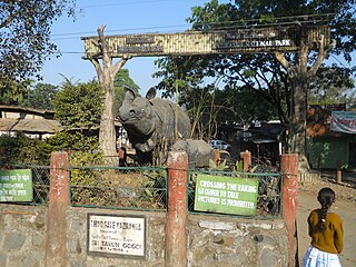
Jagiroad is a town in the state of Assam. Jagiroad located in Mayong Sub-Division, in Morigaon district. It is situated on the south bank of Kolong river.
Kharupetia is a town and a municipal board in Darrang district in the Indian state of Assam. Kharupetia is a fast-developing commercial town in Mangaldoi Sub-Division under Darrang District. It is about 17 km from Mangaldoi, the District headquarters and 87 km from Guwahati, the gateway of North East region. It is connected by National Highway 15.
Kohora is a small town situated in the Golaghat district of Assam. It is the main entrance of the world-famous Kaziranga National Park. It lies on the National Highway 37(Asean Highway 1). Kohora lies between Nagaon and Golaghat.

Assam is the main and oldest state in the North-East Region of India and as the gateway to the rest of the Seven Sister States. The land of red river and blue hills, Assam comprises three main geographical areas: the Brahmaputra Valley which stretching along the length of the Brahmaputra river, the Barak Valley extending like a tail, and the intervening Karbi Plateau and North Cachar Hills. Assam shares its border with Meghalaya, Arunachal Pradesh, Nagaland, Manipur, Tripura, Mizoram and West Bengal; and there are National Highways leading to their capital cities. It also shares international borders with Bhutan and Bangladesh and is very close to Myanmar. In ancient times Assam was known as Pragjyotisha or Pragjyotishpura, and Kamarupa.
Kaliabor, a sub-division town in Nagaon district of Assam situated at a distance of 48 km east of Nagaon town. It was the headquarters of Borphukans during the Ahom era. Kaliabor lies in the middle of assam and surrounded in the north by the Brahmaputra, in the south by the hills of Karbi Anglong district, in the east by Kaziranga National Park under Golaghat district and in the west by New Gatanga & Samaguri under Nagaon Sadar Sub-Division.
Narayanpur is a developmental block (place) located in the Lakhimpur district of the northeastern Indian state of Assam, within the North Lakhimpur subdivision. It falls under the Bihpuria constituency of the Assam Legislative Assembly and is served by the Narayanpur Police Station. The town of Narayanpur, situated at the center of the block, serves as the headquarters of the Deori Autonomous Council, the governing body of the Deori ethnic group. Narayanpur is also notable as the birthplace of several famous Vaishnavite saints, including Mahapurush Madhavdev.

Silghat is a town located on the southern banks of the Brahmaputra, in Nagaon district in the Indian state of Assam. It is 48 km northeast of Nagaon. With a river and hills, the scenery of Silghat attracts local and visitors throughout the year. Silghat is home to Kamakhya Temple, Trishuldhari, Samantagiri, Simala Garh, Manuh Kata Tumoni, heritage British era bungalows, Gandhi Asthidham, and Sudhakantha Sammanoi Khetra. Every year in March or April (Chot/Bohag), Ashokastami mela is held at Slighat's holy river bank. The Assam Cooperative Jute Mill Ltd. operates in Silghat.
Raha is a small town in Nagaon district of Assam, India, situated near the National Highway 37. The river Kolong and Kopili flows near Raha. Raha is also situated near to Chaparmukh, a small town popularly known for Chaparmukh junction, one of the prominent railway stations in Nagaon district.
Puranigudam is in the Nagaon district of Assam, India. There are several villages in Puranigudam. The main commercial center of Puranigudam, also known as Keyan Patti is located closest to Garamur. Rupahihat are to the north, Barhampur and Nagaon in the west, Chalchali in the south and Rongagorah and Samaguri in the east. The river Kolong flowes through the upper half of the area and National Highway 37 runs parallel to the river. The area is almost in the middle of the Nagaon district and situated in higher elevation than the district headquarters.
Kailashahar is the fourth largest urban area in the north eastern state of India, Tripura, located near northwest Bangladesh border. It is a Municipal council and the administrative center of the Unakoti district, this city is surrounded by unakoti hills and flows through Tripura's longest river, Manu.

Assam Tourism Development Corporation or ATDC is a state owned corporation of Assam, India. It deals with tourism services and development as a part of the Assam Tourism Department along with the Directorate of Tourism. The State Govt. of Assam set up the corporation on 9 June 1988. The ATDC is headquartered at Guwahati and has district offices across Assam. Its official slogan is "Awesome Assam."
Barapujia or most appropriately, Niz Barapujia is a large village located in Raha of Nagaon district, Assam, India. It had a total of 1245 families residing there as of the 2011 census. It is approximately 5 km from Raha, 25 km from Nagaon and 18.6 km from Morigaon. According to Census 2011 information the location code or village code of Niz Barapujia village is 284826.
2. New Gatanga Town Reference