
Mananthavady is a municipality and taluk in the Wayanad district of Kerala, India.The town is located on the banks of Mananthavady River, a tributary of the Kabini River. Mananthavady has been referred to as "Hosenkadi" in a dictum scribbled under a copper artefact found at the Ananthanathaswamy Temple at Varadoor. The dominant view on the etymology is that the word is derived from "Mane Eytha Vady ". This view is strengthened by the existence of a place called Ambukuthy, literally the location where the arrow pierced, on the outskirts of the town. This area was once ruled by the Pazhassi dynasty and the tomb of Pazhassi Raja is an important heritage site located in the heart of the town. Mananthavady was a major army camp for the British during their campaign against Pazhassi. One can still see the vestiges of the colonial period - canteen, club, barracks, rest house, cemetery - around Mananthavady. This is also the headquarters of the Adivasi Gothra Mahasabha. The District Hospital in Mananthavady is the only major treatment facility for the service of the tribal communities and other less privileged sections of Wayanad.

Kalpetta is a town and a municipality in the Wayanad district, state of Kerala, India. Kalpetta is the headquarters of Wayanad district as well as the headquarters of Vythiri taluk. It is a bustling town surrounded by dense coffee and tea plantations and mountains. It lies on the Kozhikode-Mysore National Highway NH 766 at an altitude of about 780 m above sea level. Kalpetta is 72 km from Kozhikode and 140 km from Mysore.
Sulthan Bathery, previously known as Sultan's Battery or Ganapathyvattam, is a town and municipality in Wayanad district of Kerala, India, near the borders with Tamil Nadu and Karnataka states. The largest city in Wayanad district, it is the headquarters of Sultan Bathery taluq. It is a quiet and peaceful town. The place came to be known by its new name after Mysore ruler Tipu Sultan invaded the region and used the Jain Temple located here as a battery. The pleasant weather in this beautiful town, coupled with excellent opportunities for shopping and spectacular historical sites makes the town of Sultan Bathery a popular tourist destination that is visited by tourists all year round. Located at an altitude of 1000 meters above the sea level, the town of Sultan Bathery boasts of a fantastic topography: majestic hills interspersed with valleys, cliffs and plains. Not only is Sultan Bathery now the largest town in the entire Wayanad district, but the place is also reputed for its tourism and commercial activities. The main attractions for the tourists are the pre-historic caves, jungle trails, sparkling streams and rivers and lush greenery of the undulating hills, along with many options to explore the city and its surroundings. Stopovers such as the Edakkal Caves, Chethalayam Falls, the Jain Temple, Muthanga Wildlife Sanctuary, Ambalavayal Heritage Museum and St. Mary's and Yakoob Church make this town a suitable choice for every kind of traveller, having something for everyone to see.

Gundlupet or Gundlupete in Kannada is a town in the Chamarajanagar district of the Indian state of Karnataka. This small town is about 56 km from the Mysore-Ooty / Mysore-Calicut NH 212 highway and about 200 km from Bangalore, the state capital. Gundlupet is the last town in Karnataka en route to Ooty, Wayanad, Kozhikode, situated very close to Tamil Nadu and Kerala state borders. National Highway -67 starts from Gundlupete and ends in Nagapattinam in Tamil Nadu via Ooty and Coimbatore.

Lakkidi is a rain forest located in the gateway of Wayanad district of the Indian state of Kerala.

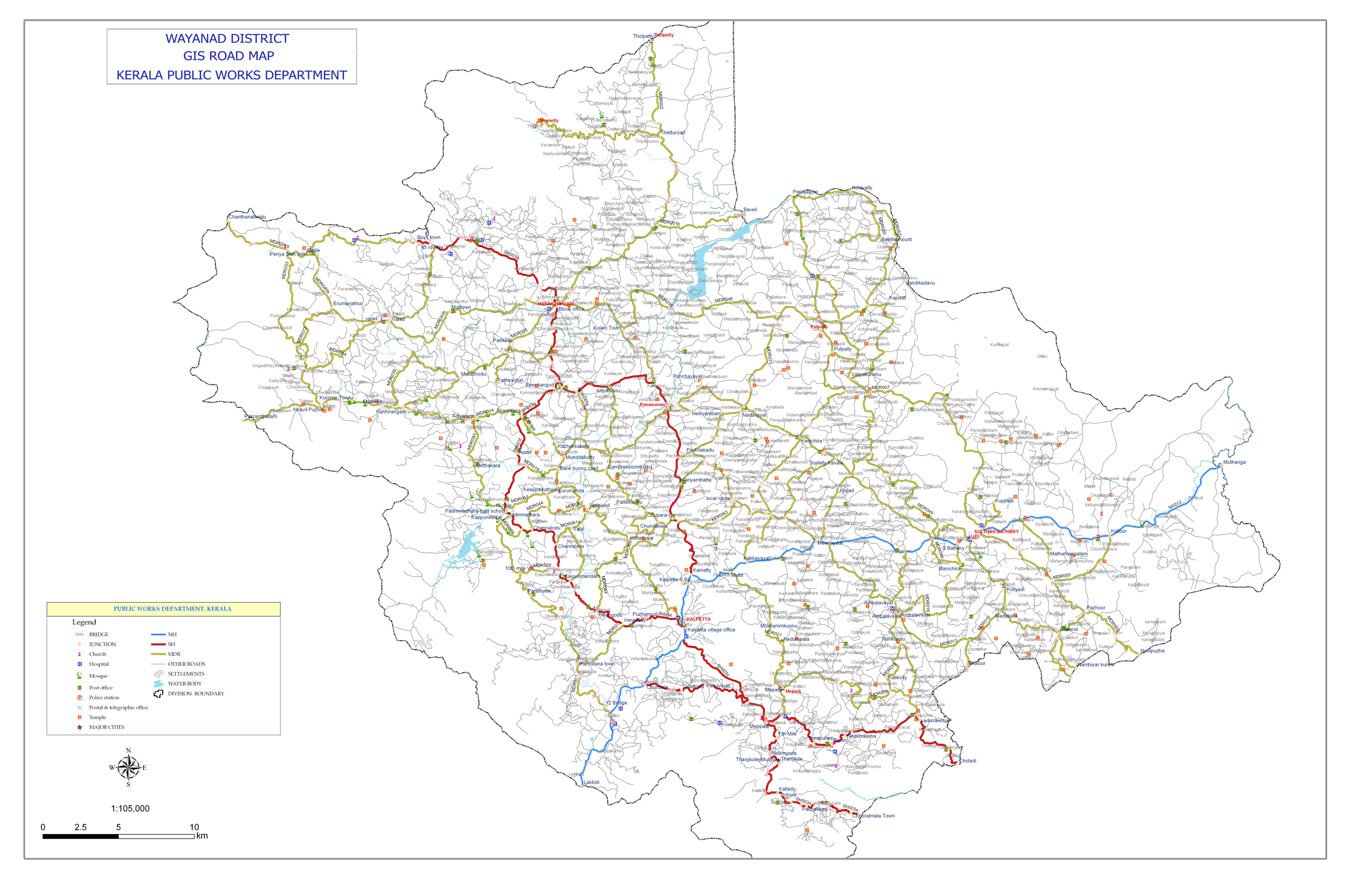
Kerala, southern most state of India has a network of 11 National Highways, 72 State Highways and many district roads.
State Highway 21 is a State Highway in Kerala, India that starts in Chalakudy and ends at the state boundary. The highway is 86.0 km long.
State Highway 27 is a State Highway in Kerala, India that starts in Palakkad Collectorate and ends at the state boundary. The highway is 35.0 km long.
State Highway 28 is a State Highway in Kerala, India that starts in Kozhikode and ends at the state boundary. The highway is 103.6 km long.
State Highway 30 is a State Highway in Kerala, India that starts in Thalassery and ends at the state boundary. The highway named as Thalassery Coorg Road is 55.1 km long.
Nilambur–Nanjangud line also called The golden I. T. corridor or Wayanad Railway, was a railway project to create a 5ft 6in broad gauge rail connection from the town of Nanjangud (Karnataka) to Nilambur (Kerala) through Wayanad district of Kerala and Nilagiri district of Tamil Nadu.

Vythiri is a small town and tourist destination located in the Wayanad district in the Indian state of Kerala. It is one of the three Taluks in the district with the other two being Mananthavady and Sulthan Bathery.

National Highway 766 is a National Highway in Southern India. NH 766 connects Kozhikode in Kerala with Kollegal in Karnataka via Mysore. Of the total distance of 272 km, 117 km is in Kerala and 155 is in Karnataka. At Kollegal, it joins National Highway 948, which connects Bengaluru and Coimbatore. The highway passes through dense forests of Western ghats of India. The NH-766 passes through Bandipur National Park and other reserve forests. The rapid rise in traffic of vehicles (Automobiles) in this highway has led to deaths of wild animals due to the speeding traffic, even though vehicles are not allowed from 9 P.M to 6 A.M in some stretches.
Pookode is a village in Vythiri Taluk in Wayanad district of Kerala state in India. Pookode is known for Pookode Lake and as the headquarters of Kerala Veterinary and Animal Sciences University.

The district capital of Wayanad is Kalpetta town. Kalpetta has very good road connectivity with the rest of Kerala and neighboring South Indian cities. NH766 connects Kalpetta with Kozhikode and Mysore. State Highways connect Kalpetta with Ooty in Tamil Nadu and Madikeri in Karnataka.

Krishnagiri Village is a village in Wayanad District in the state of Kerala, India. It is in a rural area of Wayanad and one of the 15 villages in Sultan Bathery Tehsil.. It is about 16 km (9.9 mi) from Kalpetta and 9 km (5.6 mi) from Sultan Bathery in NH766


