
Tirurangadi is a municipal and census town in Malapuram district of Kerala, South India. It is a historical town which is famed for its active participation in the freedom struggle, especially those dating back to 1920s. It is a Municipality and a taluk. It is located 25 km west of Malappuram, the district headquarters, 30 km south of Calicut and 140 km north of Ernakulam.

Palakkadpronunciation (help·info), also known as Palghat, is a city and municipality in the state of Kerala in southern India, spread over an area of 26.60 km2 and is the administrative headquarters of the Palakkad District. The city is situated about 350 kilometres (217 mi) north of state capital Thiruvananthapuram and 54 kilometers south west of Coimbatore, and 66 km north east of Thrissur on the Salem-Kanyakumari National Highway NH 47.

Kunnumpuram is a small town in Malappuram district of Kerala. It is located south to Kondotty, west to Vengara and north to Tirurangadi. Kunnumpuram is famous for its Palliative Care Unit.

Kerala, southern most state of India has a network of 11 National Highways, 72 State Highways and many district roads.

Vengara is a town in Malappuram district of Kerala state.
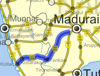
National Highway 744 or NH 744 is a National Highway in Southern India that links Kollam (Quilon) in Kerala with Madurai in Tamil Nadu. Starting from NH 66 at Chinnakkada in Kollam, it joins Tirumangalam in Madurai at National Highway 44 (India).
Koottilangadi is a census town and outgrowth of Malappuram in the state of Kerala, India. It is a small and growing town in Malappuram district, situated at the confluence of Kadalundipuzha and Cherupuzha rivers, thus giving the place its name. National highway 966, which connects Calicut with Malappuram and Palakkad, passes through Koottilangadi. Koottilangadi bridge constructed over Kadalundi river is considered as the gateway to Malappuram municipality. Koottilangadi Grama Panchayat Ward is currently owned by 19.
Morayur or Morayoor is a tiny town near Malappuram Located on Palakkad-Kozhikoad Highway(NH 966). It is one of the villages in Malappuram district of state of Kerala.

National Highway 966 is a highway which connects Palakkad, Malappuram and Kozhikode district headquarters in Kerala. It was previously known as NH 213. It covers a distance of 125 km. At Ramanattukara, near Kozhikode, it joins NH 66. At Palakkad it joins NH 544, which connects Coimbatore and Cochin through Palakkad.

Angadipuram is a Town, an important pilgrimage centre for Hindus located in Malappuram District of Kerala, southern India. It is located on the Chennai-Kozhikode road 17 km from Malappuram, the district Headquarters, on the southern bank of a tributary of Kadalundipuzha. Angadipuram was the capital of the powerful medieval kingdom of Valluvanad. Angadipuram is famous for its two temples, the Thirumanthamkunnu Temple and the Tali Temple. The principle deities of the Thirumanthamkunnu Temple are Goddess Bhagavati and Lord Siva. The Puttanangadi mosque has Arabic inscriptions engraved on one of its planks.
State Highway 23 is a State Highway in Kerala, India that starts in Shoranur Railway Station and ends by joining National Highway 213 at Perinthalmanna. The highway is 39.3 km long.
State Highway 29 is a State Highway in Kerala, India that starts at junction of NH 212 at Chundale near Kalpetta and ends in Kerala State Boundary with Tamil Nadu. This highway was originally Kozhikode - Vythiri - State Border and was 97 km long. After the section of the highway from Kozhikode until Chundale became part of NH 212, this highway is now 31.0 km long.
State Highway 51 is a State Highway in Kerala, India that starts in Kodakara and ends in Kodungallur. The highway is 27 km long.
State Highway 71 is a State Highway in Kerala, India that starts in Tirur passing through Malappuram and ends in Manjeri. The highway is 39.0 km long.
State Highway 74 is a State Highway in Kerala, India that starts in Vazhakode and ends in Alathur. The highway is 33.69 km long. The road connects important towns Chelakkara and Pazhayannur

Oorakam Mala is a mount near Malappuram, Kerala, India. It is in Oorakam village, bordering Nediyiruppu and Kannamangalam villages. Visible from the Malappuram - Parappanangadi state highway between Vengara and Panakkad and is around 6 km to the peak of the mount from the highway. There is a Jain temple at the top of the mountain, which is around 2000 years old.

Valluvambram Junction is a small town in Malappuram District, in India.

The district capital of Wayanad is Kalpetta town. Kalpetta has very good road connectivity with the rest of Kerala and neighboring South Indian cities. NH766 connects Kalpetta with Kozhikode and Mysore. State Highways connect Kalpetta with Ooty in Tamil Nadu and Madikeri in Karnataka.
The transportation in Malappuram district includes road, rail, air, and mass transit.


