
Changanassery, is a municipality in the Kottayam district of Kerala, India. It is located 17 km (10.6 mi) south of the district headquarters in Kottayam and about 115 km (71.5 mi) north of the state capital Thiruvananthapuram. As per the 2011 Indian census, Changanassery has a population of 47,485 people, and a population density of 3,517/km2 (9,110/sq mi).

Morigaon district is an administrative district in the state of Assam in India. The district headquarters is located at Morigaon. The ancient place of occult Mayong is located in this district as well as Pobitora Wildlife Sanctuary.
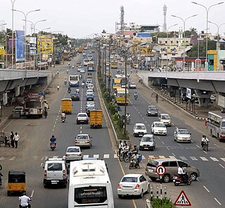
Pallavaram is a southern suburb of Chennai, India. It lies in the district of Chengalpattu, situated within the Chennai Metropolitan Area, Tamil Nadu state.
Kerala is a state in south-western India. Most of Kerala's 33.4 million people are ethnically Malayalis. People of Kerala trace their origins to Dravidians and Aryans. Kerala people have mixed ancestry. Additional ancestries derive from millennia of trade links across the Arabian Sea, whereby people of Arab, Jewish, Syrian, Portuguese, English and other ethnicities settled in Kerala. Many of these immigrants intermarried with native Malayalam speakers resulting in formation of many Muslim and Christian groups in Kerala. Some Muslims and Christians thus take lineage from Middle Eastern and European settlers who mixed with native population.

The Perambalur District is in the center of Tamil Nadu and is 267 kilometers from Chennai in the south. The district covers an area of 1,757 square kilometers, located between 10.54' and 11.30' degrees of Northern latitude and 78.40' and 79.30' degrees of Eastern longitude. There are no coastal lines in this inland district.
Kairana is a city and a municipal board in Shamli district of the Indian state of Uttar Pradesh. It is approximately 14 km (8.7 mi) from Shamli city.

Khatima is a city and a municipal board in Udham Singh Nagar district in the Indian state of Uttarakhand.

Peralasseri is a census town and Panchayat headquarters in Kannur district in the Indian state of Kerala, situated on the Kannur-Kuthuparamba State Highway 38 (Kerala), 12 km from Kannur city, on the bank of Anjarakandy river.

Thiruvankulam is a census town in Thrippunithura municipality, in Ernakulam district, Kerala, India. The area is a part of the Kochi metropolitan area. NH 85 passes through Thiruvankulam. The Karingachira junction is the location of the southern terminus of the Seaport-Airport Road, which connects the Cochin International Airport and the Cochin Port.

Anicadu is a census village in Anicadu gram panchayat in the Mallapally taluk of the district of Pathanamthitta in Kerala, India. As of 2011, it had a population of 14,678.
Kottangal is a census village in Kottangal gram panchayat in the Mallapally taluk of the district of Pathanamthitta in Kerala. As of 2011, it had a population of 17,174.
Chethipuzha is in Changanacherry, in kottayam district, Kerala, India. Chethipuzha is home to many prominent educational and healthcare institutions, including Placid Vidya Vihar, Kristu Jyothi School, and the St. Thomas Hospital, Chethipuzha.

Ezhumattoor is a census village in Ezhumattoor gram panchayat in the Mallapally taluk of the district of Pathanamthitta in Kerala. As of 2011, it had a population of 16,837.
Kallooppara is a census village in Kallooppara gram panchayat in the Mallapally taluk of the district of Pathanamthitta in Kerala. As of 2011, it had a population of 16,837.
Peringara is a village and in the Peringara gram panchayat in Pathanamthitta district, Kerala. Peringara is located 3.9 km from Thiruvalla. The gram panchayat includes the wards of Mepral, Idinjillam, Perumthuruthy, and Chathenkary.
Perumpetty is a census village in Kottanad gram panchayat in the Mallapally taluk of the district of Pathanamthitta in Kerala. As of 2011, it had a population of 14,396.
This is a list of States and Union Territories of India by Bengali speakers at the time of the 2011 Census.

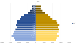
The 2011 census of India or the 15th Indian census was conducted in two phases, house listing and population enumeration. The House listing phase began on 1 April 2010 and involved the collection of information about all buildings. Information for National Population Register (NPR) was also collected in the first phase, which will be used to issue a 12-digit unique identification number to all registered Indian residents by Unique Identification Authority of India. The second population enumeration phase was conducted between 9 and 28 February 2011. Census has been conducted in India since 1872 and 2011 marks the first time biometric information was collected. According to the provisional reports released on 31 March 2011, the Indian population increased to 1.21 billion with a decadal growth of 17.70%. Adult literacy rate increased to 74.04% with a decadal growth of 9.21%. The motto of the census was Our Census, Our Future.
Mathur is a residential area located north of Chennai, a metropolitan city in Tamil Nadu, India. Mathur is administered by the Greater Chennai Corporation and belongs to Madhavaram taluk of Chennai district.
Bhinder or Bhindar is a town in Udaipur District, that is located 315 km (196 mi) from the state's main city Jaipur. Bhinder borders the Chittorgarh District in Rajasthan and is located 58 kilometres (36 mi) south-east of Udaipur. Notable tourist sites nearby include Sita Mata Wildlife Sanctuary, Jaisamand Sanctuary, and Jaisamand Lake. Bhinder is surrounded by four lakes.

