This article has multiple issues. Please help improve it or discuss these issues on the talk page . (Learn how and when to remove these messages)
|
Pala | |
|---|---|
 Pala town | |
 Pala  Pala | |
| Coordinates: 9°42′46″N76°41′01″E / 9.71278°N 76.68353°E | |
| Country | India |
| State | Kerala |
| District | Kottayam |
| Government | |
| • Type | Municipality |
| • Body | Pala Municipality |
| • Municipal Chairperson | Diya Binu Pulikkakandam |
| • Member of the Legislative Assembly of Kerala (MLA) | Mani C. Kappan |
| Area | |
• Total | 16.06 km2 (6.20 sq mi) |
| Elevation | 31 m (102 ft) |
| Population (2011) [2] | |
• Total | 22,056 |
| • Density | 1,373/km2 (3,557/sq mi) |
| Languages | |
| • Official | Malayalam, English |
| Time zone | UTC+5:30 (IST) |
| PIN | 686573, 686574, 686575 |
| Telephone code | +9148 22 |
| Vehicle registration | KL 35, KL 67 |
| Nearest city | Kottayam |
| Vidhan Sabha constituency | Pala |
| Lok Sabha constituency | Kottayam |
Pala (IPA: [paːlaː] ) is a municipality [3] in the Kottayam district of Kerala, India. It is located 28 km (17.4 mi) north of the district headquarters in Kottayam and about 167 km (103.8 mi) north of the state capital Thiruvananthapuram. As per the 2011 Indian census, Pala has a population of 22,056, and a population density of 1,373/km2 (3,560/sq mi).
Contents
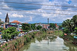
Pala is on the banks of the Meenachil River and is a major hub of Syrian Christian culture in Kerala. [4]
