Kumily

Last updated

Kumily
Plantation Town
Tea Estate.jpg
Tea plantations at Kumily
India Kerala location map.svg
Red pog.svg
Kumily
Location in Kerala, India
India location map.svg
Red pog.svg
Kumily
Kumily (India)
Coordinates: 9°37′0″N77°9′0″E / 9.61667°N 77.15000°E / 9.61667; 77.15000
CountryFlag of India.svg  India
State Kerala
District Idukki
Taluk Peerumedu
Named for Thekkady tourist spot
Government
  Type Panchayati raj (India)
  BodyKumily Grama Panchayat
Area
  Total203.31 km2 (78.50 sq mi)
Elevation
880 m (2,890 ft)
Population
 (2011)
  Total30,276
  Density150/km2 (390/sq mi)
Languages
  Official Malayalam, English [1]
Time zone UTC+5:30 (IST)
PIN
685509
Area code 04869
Nearest City Kottayam, Kochi
Assembly constituency Peerumedu
Lok Sabha constituency Idukki

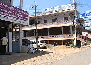
Kumily, also spelt as Kumaly is a revenue village and Gram Panchayat in the Idukki district of the state of Kerala. It is a town in Cardamom Hills near Thekkady and Periyar Tiger Reserve. Kumily is a gateway town into Kerala from Tamil Nadu. [2]

Contents

History

The present-day Kumily has roots in the British colonial period. The area was once owned by the Thekkumkoor rajas in central Travancore and later when Marthanda Varma conducted his campaigns in central Travancore, regions including Kumily came under the kingdom of Travancore. Till the end of the 19th century, the area was under control of Poonjar kings. But the drastic and significant changes occurred in the region by the advent of British powers. They obtained these regions from the local rulers and transformed the forestlands into cultivatable one. Large-scale production of cash crops like cardamom, pepper, coffee, cinnamon etc. started in the hilly terrains. Many people from in and outside Kerala were brought to work in these plantations. [3]

Demographics

As of 2011 Census, Kumily village had population of 30,276 where 15,162 are males and 15,114 are females. Kumily village spreads over an area of 203.31 km2 (78.50 sq mi) with 7,404 families residing in it. The average sex ratio was 997 lower than the state average of 1084. In Kumily, 10.3% of the population was under 6 years of age. Kumily had an average literacy of 90.5% lower than the state average of 94%; male literacy was 93.6% and female literacy was .87.4%. [4]

Transportation

Two national highways pass through Kumily town.


The nearest railway station is 60 km away at Theni. Madurai International Airport is the nearest airport to Kumily of about 120km km distance.

See also

Related Research Articles

<span class="mw-page-title-main">Idukki district</span> District in Kerala, India

Idukki is one of the 14 districts in the Indian state of Kerala in the southwest of the country. It is the largest district in Kerala and lies amid the Cardamom Hills of Western Ghats in Kerala. Idukki district contains two municipal towns - Kattappana and Thodupuzha, and five taluks.

<span class="mw-page-title-main">Muvattupuzha</span> Municipality in Kerala, India

Muvattupuzha is a town, municipality in the midlands directly to the east of Kochi in Ernakulam district, Kerala, India. It is located about 36 km (22 mi) from downtown Kochi, and is a growing urban centre in central Kerala. The town is also the starting point of the Muvattupuzhayar, which is a confluence formed by three rivers: the Thodupuzhayar, Kaliyar, and Kothayar.

<span class="mw-page-title-main">Thekkady</span> Hill station in Kerala, India

Thekkady is a town near Periyar National Park, an important tourist attraction in the Kerala state of India. The name Thekkady is derived from the word "thekku" which means teak. Temperatures are lowest in the months of December–January and highest in the months of April–May.

Koottickal is a town at the base of Western Ghats mountain ranges in the Kottayam district, in the state of Kerala. It is 2,000 feet (610 m) above sea level and is situated on the eastern border of Kottayam District, 55 km from Kottayam, and around 5 km away from Mundakayam on the NH 220. There are streams and waterfalls in the surrounding places. The Muthukora Hills are nearby. Urban centres in Kottayam and Ernakulam districts can be viewed from the top of Muthukora Hills.

<span class="mw-page-title-main">Cardamom Hills</span> Mountain range in Kerala, India

The Cardamom Hills or Yela Mala are mountain range of southern India and part of the southern Western Ghats located in Idukki district, Kerala, India. Their name comes from the cardamom spice grown in much of the hills' cool elevation, which also supports pepper and coffee. The Western Ghats and Periyar Sub-Cluster including the Cardamom Hills are UNESCO World Heritage Sites.

<span class="mw-page-title-main">Ponkunnam</span> Town in Kerala, India

Ponkunnam is a census town in Kerala, India, part of Kottayam district under Kanjirappally taluk. Ponkunnam literally means golden mountain (ponn = gold, kunn = mountain). Nearby towns are Kanjirappalli, Manimala and Pala. This part of Kerala is famous for its fertile land and rubber plantations. It is at an altitude of 495 ft (151 m) above mean sea level. The town is at the junction of two major roads in Kerala: NH 183 and Main Eastern Highway. The climate is moderate with timely cold breezes and the town is the gateway to the Western Ghats. The town is famous for its volleyball traditions and customs. Almost every year there is an ever-rolling volleyball tournament happening in Ponkunnam Mahatma Gandhi Mini Stadium.

<span class="mw-page-title-main">Peermade</span> Hill station in Kerala, India

Peermade, also spelt Peerumedu is a village, Grama Panchayat and hill station in the state of Kerala, in southwestern India. It lies 915 metres (3,002 ft) above sea level in the Western Ghats (Sahyadri) about 85 kilometres (53 mi) east of Kottayam on the way to Thekkady through the nearby city of Kanjirappally.

<span class="mw-page-title-main">Kattappana</span> Municipality in Kerala, India

Kattappana stands as a vibrant municipal town nestled within the lush embrace of the Sahyadri in Kerala state, India. Positioned at an elevation of approximately 2,788.71–2,952.76 feet (850.00–900.00 m) above sea level, it proudly serves as the principal urban hub in the high ranges of Idukki district. This town holds the distinction of being the second to attain municipal status in the Idukki District. Renowned for its bustling commerce, Kattappana thrives on agriculture and spice production, shaping its identity as a significant commercial center.

Nedumkandam is the headquarters of Udumbanchola taluk which is situated in Idukki district of the Indian state of Kerala. Nedumkandam is among the fastest growing towns in the Idukki district. Nedumkandam is well known for its spices production and is a major contributor to the production of spices like cardamom and pepper. This town situated an average elevation of 900 meter above sea level and maximum elevation respectively 1190 meter 1100 meter and 975 meter and is a destination for economical stay and shopping for tourists in the popular Kumily-Munnar tourist route.

<span class="mw-page-title-main">Main Eastern Highway</span>

The Main Eastern Highway is the lifeline of the high range townships of the Travancore region of Kerala state, India. It is also known as Punalur-Muvattupuzha Highway. Main Eastern Highway is categorized as State Highway - 08 of Kerala. It is the second longest State Highway of Kerala covering a distance of 153.6 km. The districts it passes through are Kollam, Pathanamthitta, Kottayam, Idukki and Ernakulam.

<span class="mw-page-title-main">Yendayar</span> Town in Kerala, India

Yendayar is a village in Kottayam district, Kerala, India that is totally surrounded by hills. According to local tradition, Mr. J.J. Murphy named the place, which was to be his home until death in 1957, after his mother and the local river. Yendayar is a combination of 'yen' (my) 'thai' (mother) and 'ar' (river). Murphy had come in 1904 to the place which was a thick forest and had no name or people then. He had traveled a long way to reach there. There he established India's first successful rubber plantation. He brought workers from near and far – Kerala, Tamil Nadu, and Karnataka.

<span class="mw-page-title-main">Elappara</span> Town in Kerala, India

Elappara is a town in Idukki district in the southwestern Indian state of Kerala. It is one of the panchayaths in Peerumedu taluk. The area is marked by a cool climate as the region is situated at an elevation of over 1,000 m (3,300 ft) above sea level. Elappara is famous for its vast tea plantations.

<span class="mw-page-title-main">Vandiperiyar</span> Town in Kerala, India

Vandiperiyar, IPA:[ʋɐɳɖipːeɾijɐːr], is a spice village in Idukki district, in the Indian state of Kerala. It is known for tourism, tea and coffee plantations, black pepper and other spice products. It is also known as an educational city and a number of tea factories are situated in the town. The Periyar River flows through the town. Colleges: govt poly technic college. Schools : phss, st Joseph, high range, goodluck educations, govt upper primary,fathima school, govt lower primary, trinity garden.

<span class="mw-page-title-main">Anakkara (Idukki)</span> Village in Kerala, India

Anakkara is a geographic area of around 50 square kilometres that spans across Vandanmedu, Chakkupallam Panchayats in the Udumbanchola Taluk of Idukki District. Anakkara is the administrative capital of Chakkupallam Grama Panchayat and Anakkara Revenue Village. Situated at about 18 kilometers (11 mi) from Thekkady wildlife sanctuary on the Kumily-Munnar state highway, Anakkara is a fast-growing tourist destination for its unique spice gardens and many picnic spots in and around. It is one of the 36 distinct places identified by Government of India and United Nations Development Programme for exploring and promoting the unique tourism potential of these places.

National Highways 183 is located in India. It connects Kollam High school Jn in Kerala with Dindigul in Tamil Nadu. Starting from Kollam it runs northwards to Thiruvalla and turns east at Kottayam and runs along the northern border of Periyar Wildlife Sanctuary before crossing the border into Tamil Nadu and end near Dindigul, where it joins NH 83(Coimbatore - Nagapattinam). This highway was previously known as NH 220.

Koruthodu is a village/town in Kanjirappally Taluk, Kottayam District of Kerala state, India. It is situated on the Highway connecting Mundakayam to Sabarimala temple, Kerala, and is at the border of Pathanamthitta, Kottayam and Idukki districts. The nearest town Mundakayam is 13 Kilometers from Koruthodu. The river Azhutha runs through the borders of this village. Nearby locations include Kanamala, Vandanpathal, Mundakkayam and Panakkachira.

<span class="mw-page-title-main">Panchalimedu</span> Hill station in Kerala, India

Panchalimedu is a hill station and view point near Kuttikkanam in Peerumedu tehsil of Idukki district in the Indian state of Kerala. On the Makar Sankranti day, many Ayyappa devotees camps there to witness the sacred Makaravilakku that appears in the Ponnambalamedu near Sabarimala temple. On Good Fridays, Christians come here to follow the way of the cross here.

The Kottayam–Kumily Road, better known as K K Road is the State Highway connecting Kottayam and Idukki districts of Kerala state, India. It is designated as State Highway 13 by the Kerala Public Works Department. It shares its route with National Highway 183 (NH 183), and it is 107.9 kilometres (67.0 mi) long. It is the first rubberised road in Kerala.

The High Ranges of Kerala is a hilly tract located across the Kerala state of southern India and is treated as a part of the Western Ghats.

Parathanam is a Town at the base of Western Ghats mountain ranges in the Kottayam district, Kerala. It is 2,000 feet above sea level and is situated on the eastern border of Kottayam District, 60 km from Kottayam, 12 km away from Poonjar and around 8 km away from Mundakayam on the NH 220.

References

  1. "The Kerala Official Language (Legislation) Act, 1969" (PDF).
  2. "Kumily - the plantation town". Department of Tourism, Government of Kerala. Retrieved 8 February 2024.
  3. "History, Kumily panchayat- details, Periyar, Thekkady, Idukki, Kerala - www.keralatourism.org › periyar". www.keralatourism.org. Retrieved 7 December 2016.
  4. Kerala, Directorate of Census Operations. District Census Handbook, Idukki (PDF). Thiruvananthapuram: Directorateof Census Operations,Kerala. p. 70,71. Retrieved 14 July 2020.
  5. "New highways notification dated March, 2014" (PDF). The Gazette of India - Ministry of Road Transport and Highways . Retrieved 16 July 2018.
  6. "National Highway work from next month". The Hindu . Retrieved 16 September 2016.