
Attingal is a municipality in Thiruvananthapuram metropolitan area in Thiruvananthapuram district of Kerala state, India. It was the location of the Attingal kingdom, under Travancore. It is the headquarters of Chirayinkeezhu Taluk, and the important government institutions of the taluk such as the Taluk office, court complex, office of the deputy superintendent of Police, civil station, and treasuries are situated in Attingal. It is one of the oldest municipalities of Kerala which was constituted prior to its independence in 1924. In 1914 itself Attingal Town Improvement Authority (TIA) was formed which was the term used before the municipality regulation act of 1922. Attingal Town is located 25 kilometres (16 mi) north of Thiruvananthapuram. Attingal is the 3rd densely populated municipality in the district.

Neyyattinkara, is a significant municipal town and a prominent center for both industry and commerce, positioned at the southernmost tip of the Thiruvananthapuram metropolitan area in Thiruvananthapuram, the capital city of Kerala State. It also serves as the administrative headquarters of Neyyattinkara Taluk.Nestled along the banks of the Neyyar River, one of the district's principal rivers, the town derives its name from its location, with 'Neyyatinkara' in Malayalam translating to 'the shore of the river Neyyar.' Neyyattinkara ranks as the second most densely populated municipality in the district, following Varkala. Notably, the Vizhinjam International Seaport Thiruvananthapuram is situated within Neyyattinkara Taluk."In the Vizhinjam International Seaport Thiruvananthapuram, the port international code IN NYY 1, the "NYY" represents Neyyattinkara

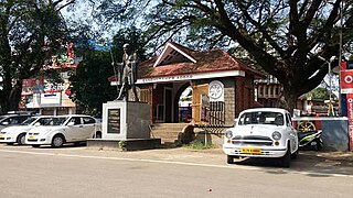
Nedumangad is a municipal town in the Thiruvananthapuram district in the Indian state of Kerala. It is the headquarters of Nedumangad Tehsil and Nedumangad Revenue Division. It is a suburb of the extended metropolitan region of Thiruvananthapuram. It is located around 16 km (9.9 mi) to the north-east of Thiruvananthapuram on the State Highway 2. It is an important commercial center in the district. It is a growing commercial and educational hub and all important government institutions are situated in the town. The Nedumangadu market has significance in southern Kerala.

Ponmudi is a hill station in the Peringamala gramapanchayath of Thiruvananthapuram district of Kerala in India. It is located 22km west of Vithura town, 53 km north-east of Thiruvananthapuram City, 78 km south-east of Varkala town and 69 km north-east of Kovalam Beach at an altitude of 1,100 m (3,600 ft). Ponmudi (Varayadumotta) peak is a part of the Western Ghats mountain range that runs parallel to the Arabian Sea. Ponmudi is a popular honeymoon destination in South India. The normal temperature of Ponmudi is between 18 and 25 °C.

Thiruvananthapuram District is the southernmost district in the Indian state of Kerala. The district was created in 1949, with its headquarters in the city of Thiruvananthapuram, which is also Kerala's administrative centre. The present district was created in 1956 by separating the four southernmost Taluks of the erstwhile district to form Kanyakumari district. The city of Thiruvananthapuram is also known as the Information technology capital of the State, since it is home to the first and largest IT park in India, Technopark, established in 1990. The district is home to more than 9% of total population of the state.
Nemom is an area in the city of Thiruvananthapuram. It is surrounded by Thirumala in the north, Malayinkeezhu in the north-east, Balaramapuram in the south-east, Kovalam in the south and Thiruvallam in the west. Nemom falls within the municipal corporation of Thiruvananthapuram, though partly exclusive. It is connected with Thiruvananthapuram, Neyyattinkara, Vizhinjam, Poovar, Kattakkada, Nagarcoil, and Kanyakumari through the main arterial highway National Highway 66.
Adoor is a municipality in the Pathanamthitta district of Kerala, India. It is the headquarters of the Adoor Taluk and Adoor Revenue Division. Adoor is located 18 km (11.2 mi) southwest of the district headquarters Pathanamthitta and 85 km (52.8 mi) north of the state capital Thiruvananthapuram.
Aryanadu is a village town in Thiruvananthapuram district, Kerala, India, lying under the foothills of the Agastyarkoodam of the Sahya mountains. The village is spread along the sides of Karamana River in the western ghats of Agasthya Mountains. The Aryanad Panchayath has border with Uzhamalakkal, Vellanad, Poovachal, Kuttichal, Vithura, Tholickode panchayaths. Aryanad is residing Nedumangad Taluk and Aruvikkara Legislative Assembly. It is situated around 25 km from Thiruvananthapuram. G. Steephen is the current sitting MLA of Aryanad.

Chathannoor is a town in the Indian state of Kerala situated at the Kollam District on the banks of Ithikkara River. It is about 16 km (9.9 mi) from Kollam(Quilon) City. Chathannoor is around 55 km (34 mi) north of the state capital Thiruvananthapuram(Trivandrum). Chathannoor is a Special Grade Panchayath and is one of the fastest developing towns in Kerala.. Shri ChandraKumar is the current president of Chathannoor Grama Panchayat.
Mandapathinkadavu is a village in Thiruvananthapuram District in the southern Indian state of Kerala). It's located at Ottasekharamangalam panchayat in Kattakada Taluk.
Parassala is a small town located near the border of Kerala and Tamil Nadu.It comes under Thiruvananthapuram district at southern tip of Kerala. It is situated 34 km south of state capital Thiruvananthapuram in Kerala, bordering Tamil Nadu.

Purathur is a sandy coastal village and a Grama Panchayat in Tirur Taluk, Malappuram district in the state of Kerala, India. Bharathappuzha river and Tirur River merges together in Purathur and join with the Arabian Sea at Padinjarekara Azhimukham, which is also the southernmost tip of Purathur Gram panchayat. Opposite to Padinjarekara Azhimukham is Ponnani port. The village is located at the southernmost tip of Tirur Taluk and is bordered by historically important Ponnani port in Ponnani Municipality of Ponnani taluk to south.
Karakulam is a panchayat in Nedumangad Taluk in Thiruvananthapuram District in the state of Kerala, India. It is the most populated panchayat in the district according to 2011 census.

Palode is a town in Thiruvananthapuram district in the Indian state of Kerala. Palode town is 35 km (22 mi) from Thiruvananthapuram city and 17 km (11 mi) from Nedumangad municipality.There is a Helipad in palode. Palode is surrounded by Western Ghats. Jawaharlal Nehru Tropical Botanic Garden and Research Institute is situated near Palode. Mankayam Ecotourism near Brimore is 11 km (6.8 mi) away. Brimore has tea estate and plantations make Palode a gateway for tourism destination.Thenmala is 38 km (24 mi) from Palode and Ponmudi hills is 35 km. Palode is a town in Thiruvananthapuram-Thenmala -Shenkottai State Highway 2 (Kerala). Tenkasi is 75 km (47 mi) from Palode. Palode is a town located in Nedumangad Taluk of Thiruvananthapuram district in Kerala.
Vellarada is a border village situated in Thiruvananthapuram district in the state of Kerala, India. It is 42 km from Thiruvananthapuram. It is the southernmost part of Kerala state, sharing its border with Tamil Nadu. Vellarada is said to be the threshold to the high-range areas of the eastern part of Thiruvananthapuram district. The southernmost point of Western Ghats in Kerala is near Vellarada.
Peyad //peɪjɑd// is a place located in the suburb of Thiruvananthapuram, the capital city of Kerala state in India. The offices of Vilappil Grama Panchayath and Vilappil Village are situated at Peyad.
Venjaramoodu is a north-east suburb of Trivandrum city, the capital of Kerala. It is 9 km (5.6 mi) east of Attingal, 11 km (6.8 mi) northwest of Nedumangad and 12 km (7.5 mi) northeast of Thiruvananthapuram City.
Pozhiyoor is a village in the district of Thiruvananthapuram in the State of Kerala in India. It has gradually grown to a well known tourist destination in India. The major attractions of Poovar tourism area are in Pozhiyoor. Pozhikkara, estuary formed by river Neyyar before it falls into the mighty Arabian Sea is the centre of attraction of tourism circuit in Poovar. Golden Beach, Elephant Rock, Anantha Victoria Marthanda Varma Canal, Pieta are other major attractions in Pozhiyoor Beach area in Thiruvananthapuram. It is at the coastal border of the Indian states of Kerala and Tamil Nadu.
Nedumangad Taluk is a Taluk (tehsil) in Thiruvananthapuram district in the Indian state of Kerala. It situated in the eastern part of the Thiruvananthapuram district. It comprises 23 villages and one municipality.
Kuttichal is a village in Thiruvananthapuram district in the state of Kerala, India. The Kuttichal panchayath has borders with Aryanad, Poovachal, Kallikkad, panchayaths and Thiruneveli District of Tamil Nadu India. Kuttichal is part of Kattakada Taluk, Vellanad block panchayath and Aruvikkara Legislative Assembly. Kuttichal also has the kottor Elephant rehabilitation centre which is famous among tourists.


