
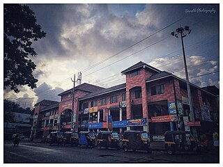
Attingal is a municipality in Thiruvananthapuram metropolitan area in Thiruvananthapuram district of Kerala state, India. It was the location of the Attingal kingdom, under Travancore. It is the headquarters of Chirayinkeezhu Taluk, and the important government institutions of the taluk such as the Taluk office, court complex, office of the deputy superintendent of Police, civil station, and treasuries are situated in Attingal. It is one of the oldest municipalities of Kerala which was constituted prior to its independence in 1924. In 1914 itself Attingal Town Improvement Authority (TIA) was formed which was the term used before the municipality regulation act of 1922. Attingal Town is located 25 kilometres (16 mi) north of Thiruvananthapuram. Attingal is the 3rd densely populated municipality in the district.

Nedumangad is a municipal town in the Thiruvananthapuram district in the Indian state of Kerala. It is the headquarters of Nedumangad Tehsil and Nedumangad Revenue Division. It is a suburb of the extended metropolitan region of Thiruvananthapuram. It is located around 16 km (9.9 mi) to the north-east of Thiruvananthapuram on the State Highway 2. It is an important commercial center in the district. It is a growing commercial and educational hub and all important government institutions are situated in the town. The Nedumangadu market has significance in southern Kerala.

Ponmudi is a hill station in the Peringamala gramapanchayath of Trivandrum District of Kerala in India. It is located 22km west of Vithura town, 53 km north-east of Trivandrum City, 78 km south-east of Varkala town and 69 km north-east of Kovalam Beach at an altitude of 1,100 m (3,600 ft). Ponmudi (Varayadumotta) peak is a part of the Western Ghats mountain range that runs parallel to the Arabian Sea. Ponmudi is a popular honeymoon destination in South India. The normal temperature of Ponmudi is between 18 and 25 °C.

Thiruvananthapuram District is the southernmost district in the Indian state of Kerala. The district was created in 1949, with its headquarters in the city of Thiruvananthapuram, which is also Kerala's administrative centre. The present district was created in 1956 by separating the four southernmost Taluks of the erstwhile district to form Kanyakumari district. The city of Thiruvananthapuram is also known as the Information technology capital of the State, since it is home to the first and largest IT park in India, Technopark, established in 1990. The district is home to more than 9% of total population of the state.
Nemom is an area in the city of Thiruvananthapuram. It is surrounded by Thirumala in the north, Malayinkeezhu in the north-east, Balaramapuram in the south-east, Kovalam in the south and Thiruvallam in the west. Nemom falls within the municipal corporation of Thiruvananthapuram, though partly exclusive. It is connected with Thiruvananthapuram, Neyyattinkara, Vizhinjam, Poovar, Kattakkada, Nagarcoil, and Kanyakumari through the main arterial highway National Highway 66.
Aryanadu is a village town in Thiruvananthapuram district, Kerala, India, lying under the foothills of the Agastyarkoodam of the Sahya mountains. The village is spread along the sides of Karamana River in the western ghats of Agasthya Mountains. The Aryanad Panchayath has border with Uzhamalakkal, Vellanad, Poovachal, Kuttichal, Vithura, Tholickode panchayaths. Aryanad is residing Nedumangad Taluk and Aruvikkara Legislative Assembly. It is situated around 25 km from Thiruvananthapuram. G. Steephen is the current sitting MLA of Aryanad.
Kattakada is a town in Thiruvananthapuram district of Kerala. It is situated 13km north of Neyyattinkara town, 18km south of Nedumangad town and 20km east of Capital City Thiruvananthapuram.
Karakulam is a panchayat in Nedumangad Taluk in Tiruvananthapuram District in the state of Kerala, India. It is the most populated panchayat in the district according to 2011 census.

Palode is a town in Thiruvananthapuram district in the Indian state of Kerala. Palode town is 35 km (22 mi) from Thiruvananthapuram city and 17 km (11 mi) from Nedumangad municipality.There is a Helipad in palode. Palode is surrounded by Western Ghats. Jawaharlal Nehru Tropical Botanic Garden and Research Institute is situated near Palode. Mankayam Ecotourism near Brimore is 11 km (6.8 mi) away. Brimore has tea estate and plantations make Palode a gateway for tourism destination.Thenmala is 38 km (24 mi) from Palode and Ponmudi hills is 35 km. Palode is a town in Thiruvananthapuram-Thenmala -Shenkottai State Highway 2 (Kerala). Tenkasi is 75 km (47 mi) from Palode. Palode is a town located in Nedumangad Taluk of Thiruvananthapuram district in Kerala.
Vellanad is a village in the Nedumangad Taluk district of Thiruvananthapuram district in the state of Kerala, India.
Vellarada is a border village situated in Thiruvananthapuram district in the state of Kerala, India. It is 42 km from Thiruvananthapuram. It is the southernmost part of Kerala state, sharing its border with Tamil Nadu. Vellarada is said to be the threshold to the high-range areas of the eastern part of Thiruvananthapuram district. The southernmost point of Western Ghats in Kerala is near Vellarada.
Vembayam is a village in Thiruvananthapuram district in the state of Kerala, India.
Neyyattinkara is a Taluk (tehsil) located in the southern region of Thiruvananthapuram district, in the Indian state of Kerala. This taluk encompasses a total of 21 villages and one municipality, making it the southernmost taluk in the state. Notably, the Vizhinjam International Seaport Thiruvananthapuram is situated within Neyyattinkara Taluk."
Vembannur is a village located in the Nedumangad taluk of the Thiruvananthapuram District in Kerala, India. Vembannur comes under the Aruvikkara panchayat of the Nedumangad Taluk.
Sabarimala Railway is a proposed 111 kilometres (69 mi) railway line from Angamaly to Erumeli, near Sabarimala that was sanctioned in 1998 by Indian Railways. According to a memorandum of understanding signed between the Kerala State and the Ministry of Railways on 27 January 2016, commercially viable railway projects will be identified and handed over to the Special Purpose Vehicle (SPV) to be fast-tracked on a 51:49 per cent equity basis. The SPV has discussed the extension to Punalur. The currently proposed Sabarimala railway is under PMO - Proactive government and timely implementation (Pragati); will be monitored by the Prime Minister's Office. The proposed railway line will be a great relief to the transportation problems faced by Idukki, Kottayam, and Pathanamthitta districts. Railways have agreed to start the project once the Kerala Rail Development Corporation gives the revised estimate for the project.
Perayam is a village located near Palode in Thiruvananthapuram District of Kerala State of south India.
Meenankal is a village in Thiruvananthapuram district in the state of Kerala, India, and located around 5 kilometers away from the Peppara Wildlife Sanctuary. Meenankal has border with Uzhamalakkal, Vellanad, Anad, Kuttichal, Vithura, Tholickode panchayaths and Thiruneveli District of Tamil Nadu, India. It's located in the Nedumangad Taluk and Aruvikkara Legislative Assembly. It is situated around 35 km away from Thiruvananthapuram city.
This District has four types of administrative hierarchies:
Nedumangad State assembly constituency is one of the 140 state legislative assembly constituencies at the state Kerala in southern India. It is also one of the 7 state legislative assembly constituencies included in the Attingal Lok Sabha constituency. As of the 2021 assembly elections, the current MLA is G. R. Anil current minister for food and civil supplies, Government of Kerala of CPI.


