
Alappuzha district, is one of the 14 districts in the Indian state of Kerala. It was formed as Alleppey district on 17 August 1957, the name of the district being changed to Alappuzha in 1990, and is the smallest district of Kerala. Alleppey town, the district headquarters, was renamed Alappuzha in 2012, even though the anglicised name is still commonly used to describe the town as well as the district.

Thiruvananthapuram, formerly known as Trivandrum, is the capital of the Indian state of Kerala. It is the most populous city in Kerala with a population of 957,730 as of 2011. The encompassing urban agglomeration population is around 1.68 million. Located on the west coast of India near the extreme south of the mainland, Thiruvananthapuram is a major information technology hub in Kerala and contributes 55% of the state's software exports as of 2016. Referred to by Mahatma Gandhi as the "Evergreen city of India", the city is characterised by its undulating terrain of low coastal hills.

Pathanamthitta District, is one of the 14 districts in the Indian state of Kerala. The district headquarters is in the town of Pathanamthitta. There are four municipalities in Pathanamthitta: Adoor, Pandalam, Pathanamthitta and Thiruvalla.

Palakkad is one of the 14 districts in the Indian state of Kerala. It was carved out from the southeastern region of the former Malabar District on 1 January 1957. It is located at the centre of Kerala. It is the largest district in the state since 2006. The city of Palakkad is the district headquarters. Palakkad is bordered on the northwest by the Malappuram district, on the southwest by the Thrissur district, on the northeast by Nilgiris district, and on the east by Coimbatore district of Tamil Nadu. The district is nicknamed "The granary of Kerala". Palakkad is the gateway to Kerala due to the presence of the Palakkad Gap, in the Western Ghats. The 2,383 m high Anginda peak, which is situated in the border of Palakkad district, Nilgiris district, and Malappuram district, in Silent Valley National Park, is the highest point of elevation in Palakkad district. Palakkad city is located just 50 km away from Coimbatore, a major city in Tamil Nadu state.

Neyyattinkara, is a Municipal Town and a major industrial and commercial hub located at the southern tip of Thiruvananthapuram metropolitan area in Trivandrum, the capital of Kerala State, and also the headquarters of Neyyattinkara Taluk. The town is situated on the banks of Neyyar River, one of the principal rivers in the district and hence its name. Neyyatinkara in Malayalam literally means "the shore of the river Neyyar". Neyyattinkara is the second most densely populated municipality in the district after Varkala.
Nedumangad is a town and municipality in Thiruvananthapuram metropolitan area of Thiruvananthapuram district in the Indian state of Kerala, and is the headquarters of Nedumangad tehsil and Nedumangad Revenue Division (RDO). It is a suburb of the extended metropolitan region of Thiruvananthapuram city. It is located around 16 km to the north-east of Thiruvananthapuram city on the Thiruvananthapuram – Shenkottah. It is an important commercial center in the district. It is a growing commercial and educational hub and all important government institutions are situated in the town. Nedumangadu Market is important in South Kerala.
Kollam district, is one of 14 districts of the state of Kerala, India. The district has a cross-section of Kerala's natural attributes; it is endowed with a long coastline, a major Laccadive Sea seaport and an inland lake. The district has many water bodies. Kallada River is one among them, and the east side land of river is East Kallada and the west side land is West Kallada.

Thiruvananthapuram District, is the southernmost district in the Indian state of Kerala. The district was created in 1949, with its headquarters in the city of Thiruvananthapuram, which is also Kerala's administrative centre. The present district was created in 1956 by separating the four southernmost Taluks of the erstwhile district to form Kanyakumari district. The city of Thiruvananthapuram is also known as the Information technology capital of the State, since it is home to the first and largest IT park in India, Technopark, established in 1990. The district is home to more than 9% of total population of the state.

Kozhikode, or Calicut district, is one of the 14 districts in the Indian state of Kerala, along its Southwestern Malabar Coast. The city of Kozhikode, also known as Calicut, is the district headquarters. The district is 67.15% urbanised.
Kerala is a state in south-western India. Most of Kerala's 34.8 million people are ethnically Malayalis. Most of the Malayalam and English speaking Keralites derive their ancestry from Dravidian communities that settled in Kerala. Additional ancestries derive from millennia of trade links across the Arabian Sea, whereby people of Arab, Jewish, Syrian and other ethnicities settled in Kerala. Many of these immigrants intermarried with native Malayalam speakers resulting in formation of many Muslims and Christians in Kerala. Some Muslims and Christians thus take lineage from Middle Eastern settlers mixed with local population.

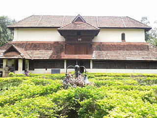
Palakkad, formerly known as Palghat, historically known as Palakkattussery is a city and municipality in the Indian state of Kerala. It is the administrative headquarters of the Palakkad District. Palakkad is most densely populated municipality and fourth-most densely populated city in Kerala. It was established before Indian independence under British rule and known by the name Palghat. Palakkad is famous for the ancient Palakkad Fort, which is in the heart of the city and was captured and rebuilt by Hyder Ali in 1766. The city is about 347 kilometres (216 mi) northeast of the state capital, Thiruvananthapuram.

Vagamon is an Indian hill station and a revenue village primarily located in Peerumedu taluk of Idukki district, and also Meenachil taluk and Kanjirappally taluk of Kottayam district in the state of Kerala, India.

Kasaragod is one of the 14 districts in the southern Indian state of Kerala. Its northern border Thalappady is located just 10 km south to Ullal, which is the southernmost portion of the major port city Mangalore, on the southwestern Malabar coast of India.
Ayiroopara is a village in Thiruvananthapuram district in the state of Kerala, India. It is a suburb of Thiruvananthapuram city.It successfully became an "institutional area" during urban planning in 2014.
Nedumangad Taluk is a Taluk (tehsil) in Thiruvananthapuram district in the Indian state of Kerala. It situated in the eastern part of the Thiruvananthapuram district. It comprises 23 villages and one municipality.

Ponnani Taluk comes under Tirur revenue division in Malappuram district of Kerala, India. Its headquarters is the town of Ponnani. Ponnani Taluk contains Ponnani Municipality and nine gram panchayats. Most of the administrative offices are located in the Mini-Civil Station at Ponnani.

Meenangadi is an old town situated on the highway NH 766 between Kalpetta and Sulthan Bathery in Wayanad District, in Kerala, India. This place is one among the Provinces where the existence of Dolmens provide an historical evidence of earlier civilisation. Coffee bean, Black pepper, Ginger, Rice and Areca are the major crops cultivated in this area. Meenangadi is famous for its Fish Market and Cattle Market. The nearest railway station is at Kozhikode at 87 km and airport is Kannur International Airport with 94 km from Meenangadi. Meenangadi is surrounded by, Ambalavayal Panchayat, Kalpetta Taluk towards west, Gudalur Taluk towards East, Mananthavady Taluk towards west. Kalpetta, Sultan Bathery, Kozhikode are the nearby Cities and towns to Meenangadi.
Kerala's first carbon neutrality project launched in Meenangadi in June 2016. Upon achieving the goals of the project, Meenangadi will be the first village in India to go completely carbon neutral. Meenangadi has a population of 33450 According to 2011 Census with two Villages Purakkadi and (Part)Krishnagiri.
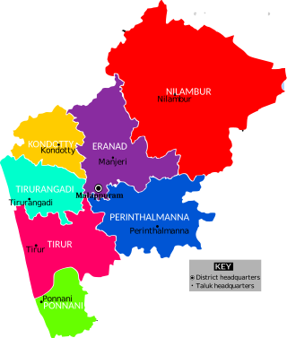
The Malappuram district has four types of administrative hierarchies:
Kollam District has four types of administrative hierarchies:


