
Nedumangad is a municipal town in the Thiruvananthapuram district in the Indian state of Kerala. It is the headquarters of Nedumangad Tehsil and Nedumangad Revenue Division. It is a suburb of the extended metropolitan region of Thiruvananthapuram. It is located around 16 km (9.9 mi) to the north-east of Thiruvananthapuram on the State Highway 2. It is an important commercial center in the district. It is a growing commercial and educational hub and all important government institutions are situated in the town. The Nedumangadu market has significance in southern Kerala.
Feroke is a Municipality and a part of Kozhikode metropolitan area under Kozhikode Development Authority (K.D.A) in the Kozhikode district of the Indian state of Kerala.

Parippally is a village in kalluvathukkal panchayat Kollam, Kerala, India. Parippally is 22 kilometres (14 mi) South of Kollam City along NH66 and 44 kilometres (27 mi) North of Thiruvananthapuram along NH66. Kollam Govt. Medical College is situated in Parippally. Varkala sivagiri is nearest major Railway station 12 km(7.5 mi).

Sengottai is a town in the Tenkasi district, of Tamil Nadu, India. It is the gateway to southern Tamil Nadu and Kerala. Spread over an area of 2.68 km2 with a population of over 26,823, the economy of the town and Sengottai Taluk revolves around the cultivation of rice,coconut,Mango,clove and pepper. Sengottai is well known in Tamil Nadu as a major market of Dosa kal. This town has lot of Black smith shops.
Kattakada is a town in Thiruvananthapuram district of Kerala. It is situated 13 km north of Neyyattinkara town, 18 km south of Nedumangad town and 20 km east of the Capital City, Thiruvananthapuram.

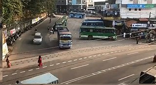
Thampanoor is the geographic center (CBD) of the Indian city of Thiruvananthapuram. The busiest railway station of the state in terms of daily passengers, Thiruvananthapuram Central, is located at Thampanoor. It caters an average of 40,908 passengers a day (2017–2018), making it as the busiest railway station in Kerala. Opposite to the railway station is the major Bus Terminal of Kerala, the Central Bus Station, Thiruvananthapuram (TVM) which is the largest and the busiest Bus station in the state connecting to almost all the parts of the State and other interstate cities. Thampanoor is administered by Thiruvananthapuram Corporation. Councillor of Thampanoor Corporation Ward is Harikumar. It falls under the Thiruvananthapuram which inturn comes under one of the seven assemblies under the Thiruvananthapuram.
Poothakkulam, also known as Bhoothakkulam, is a village in Kollam district in the state of Kerala, India. The village is located 3.9 km away from Paravur, 11.4 km from Varkala and 23 km from Kollam. In 2011, it had a population of 628,451 residents. The village covers an area of 16.56 km2.

Edava is a panchayat in Varkala Taluk, which is the northernmost tip of Thiruvananthapuram district in the state of Kerala, India. Edava is located 5km north of Varkala, 21km south of port city Kollam and 44km north of capital city Thiruvananthapuram. Kappil beach is a famous surf location.

Palode is a town in Thiruvananthapuram district in the Indian state of Kerala. Palode town is 35 km (22 mi) from Thiruvananthapuram city and 17 km (11 mi) from Nedumangad municipality.There is a Helipad in palode. Palode is surrounded by Western Ghats. Jawaharlal Nehru Tropical Botanic Garden and Research Institute is situated near Palode. Mankayam Ecotourism near Brimore is 11 km (6.8 mi) away. Brimore has tea estate and plantations make Palode a gateway for tourism destination.Thenmala is 38 km (24 mi) from Palode and Ponmudi hills is 35 km. Palode is a town in Thiruvananthapuram-Thenmala -Shenkottai State Highway 2 (Kerala). Tenkasi is 75 km (47 mi) from Palode. Palode is a town located in Nedumangad Taluk of Thiruvananthapuram district in Kerala.
Vellarada is a border village situated in Thiruvananthapuram district in the state of Kerala, India. It is 42 km from Thiruvananthapuram. It is the southernmost part of Kerala state, sharing its border with Tamil Nadu. Vellarada is said to be the threshold to the high-range areas of the eastern part of Thiruvananthapuram district. The southernmost point of Western Ghats in Kerala is near Vellarada.
Peyad //peɪjɑd// is a place located in the suburb of Thiruvananthapuram, the capital city of Kerala state in India. The offices of Vilappil Grama Panchayath and Vilappil Village are situated at Peyad.
Venjaramoodu is a north-east suburb of Trivandrum city, the capital of Kerala. It is 9 km (5.6 mi) east of Attingal, 11 km (6.8 mi) northwest of Nedumangad and 12 km (7.5 mi) northeast of Thiruvananthapuram City.
The Indian city of Thiruvananthapuram has a well-developed transport infrastructure. The city and its suburbs may be traversed using road and rail. Within the city, city buses, taxis and auto rickshaws provide mobility. Scooters and motorcycles are the favored means of personal transport. Ola, Uber and other taxi services operate there.

Thiruvananthapuram North Railway Station is an NSG–3 category Indian railway station in Thiruvananthapuram railway division of Southern Railway zone.) It is a satellite passenger railway station of Thiruvananthapuram. It is being developed to ease congestion at Thiruvananthapuram Central.
Thiruvananthapuram Pettah railway station is an NSG–6 category Indian railway station in Thiruvananthapuram railway division of Southern Railway zone. It is a railway station for inter-city trains, located at Thiruvananthapuram, in the Indian state of Kerala. The station is only 2.5 kilometres (1.6 mi) from the Thiruvananthapuram Central station. Most incoming trains from Kollam direction halt here for the convenience of passengers in the general area and to reduce the crowd at Thiruvananthapuram Central. But very few outgoing trains to north have a halt at Pettah.

Kannur railway station (station code: CAN) is an NSG–2 category Indian railway station in Palakkad railway division of Southern Railway zone. It is the largest railway station serving the City of Kannur in Kerala. It lies in the Shoranur–Mangalore section of the Southern Railway zone. It is the largest railway station in terms of area and number of tracks in North Malabar region. At ₹62 crore in financial year 2018–19, it is the fifth largest in terms of passenger revenues in Kerala, and second largest under Palakkad railway division. Almost all major trains connecting the other parts of Kerala, Tamil Nadu, Andhra Pradesh and North India halt here. Kannur and Kannur South are two different stations which serve Kannur city.
Thiruvananthapuram South Railway station is an NSG–6 category Indian railway station in Thiruvananthapuram railway division of Southern Railway zone. It is one of the six railway stations serving the city of Thiruvananthapuram which is also proposed to act as the second satellite station to Thiruvananthapuram Central railway station in the state of Kerala, India.

Kollam Junction railway station is an NSG–2 category Indian railway station in Thiruvananthapuram railway division of Southern Railway zone.) It is a junction station situated in the city of Kollam in Kerala, India. It is the second largest railway station in Kerala in terms of area and largest in terms of number of tracks and one of the oldest railway stations in the state. It is also the second busiest railway station in Kerala in terms of trains handled per day. World's third longest railway platform is situated at Kollam railway station.
Nedungolam or Nedumgolam is the Northern border town of Paravur municipality in the Kollam district of Kerala state, India. Nedungolam is very near to the world-famous-wetland in Kollam district, Polachira, which is a favorite destination for migratory birds. A census conducted on 2003 reveals that over 26,000 birds belonging to 37 species are visiting or living in the Polachira wetlands.
Palkulangara is an urban neighbourhood of Thiruvananthapuram, the capital of the Indian state of Kerala.
