Thiruvananthapuram, commonly known by its former name Trivandrum, is the capital of the Indian state of Kerala. It is the most populous city in Kerala with a population of 957,730 as of 2011. The encompassing urban agglomeration population is around 1.68 million. Located on the west coast of India near the extreme south of the mainland, Thiruvananthapuram is a major information technology hub in Kerala and contributes 55% of the state's software exports as of 2016. Referred to by Mahatma Gandhi as the "Evergreen city of India", the city is characterised by its undulating terrain of low coastal hills.

Attingal is a municipality in Thiruvananthapuram metropolitan area in Thiruvananthapuram district of Kerala state, India. It is the headquarters of Chirayinkeezhu Taluk, and the important government institutions of the taluk such as the Taluk office, court complex, office of the deputy superintendent of Police, civil station and treasuries are situated in Attingal. It is one among the oldest municipalities of Kerala which constituted prior to the independence on 1924. On 1914 itself Attingal Town Improvement Authority (TIA) was formed which was the term used before the municipality regulation act of 1922. Attingal Town is located 25 kilometres (16 mi) north of Thiruvananthapuram. Attingal is the 3rd densely populated municipality in the district.

Varkala, also known as The Pearl of the Arabian Sea, is a municipality in the Thiruvananthapuram district, situated in the Indian state of Kerala. Varkala is home to 3% of the total urban population and most densely populated municipality of the district. It is the headquarters of Varkala Taluk and one among the oldest municipalities of Kerala established in 1980. It is the second largest coastal city in the district after the state capital and northern suburb of Trivandrum City. It is located 36 kilometres north of Trivandrum, which is the capital and largest metropolitan city of Kerala and 28 km south of Kollam City.
Paravur (Paravoor), is a town and a municipality in the Kollam Metropolitan Area of Kollam district in the Indian state of Kerala. Paravur railway station is the last station in Kollam district which is on the route to Trivandrum while travelling towards South India.

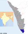
Thiruvananthapuram District is the southernmost district in the Indian state of Kerala. The district was created in 1949, with its headquarters in the city of Thiruvananthapuram, which is also Kerala's capital. The present district was created in 1956 by separating the four southernmost Taluks of the erstwhile district to form Kanyakumari district. The district is home to more than 9% of total population of the state.

Parippally is a town in Kalluvathukal Panchayath of Kollam district, Kerala, India. Paripally town is situated 12 km north-west of Varkala Town along the State Highway 64 ,15km north of Attingal Town along NH66, 22km South of Kollam City along NH66 and 44km North of State capital city Trivandrum along NH66. It is just 2 km away from the border of Kollam district on the way to Trivandrum District. Kollam Medical College is situated in Parippally.
Cherunniyoor is a village in Varkala Taluk of Thiruvananthapuram district in the state of Kerala, India.It is situated 3.4km south of Varkala Town center and also one of 5 panchayats that shares border with Varkala municipality. Palachira and Vadaserikonam junctions in cheruniyoor panchayat is two of the fastest urbanizing suburbs of Varkala.
Navaikulam is a panchayat in Varkala Taluk of Thiruvananthapuram district in the state of Kerala, India. It is situated 11km east of Varkala town and 37km north of Trivandrum City along NH66. It is also the 5th most populated panchayat in Trivandrum District.

Kadinamkulam is a panchayat and the northern suburb of Trivandrum City. It is one the residential and industrial area of Trivandrum City in Kerala, India. It is situated 22 km north of Trivandrum, 20 km from Varkala, 20 km from the Trivandrum International Airport and 22 km from Trivandrum Central Railway station and bus station. National Highway 66 is also 8 km away. Kadinamkulam is surrounded by Kadinamkulam Kayal to the east, the Arabian Sea to the west, Puthucurichy to the north and Channankara to the south. Kadinamkulam forms part of Kadinamkulam panchayat of Trivandrum district. Kinfra international apparel park, Marian Engineering College etc are situated in Kadinamkulam.
Pangode is a village and a Grama Panchayat in Trivandrum district, state of Kerala, India. The village is known for its participation in the Indian Independence Movement, through the Kallara-Pangode Struggle. It is situated on the foothills of Western Ghats.
Vakkom is a area of Trivandrum Metropolitan Area near Kadakkavoor in Thiruvananthapuram district of Kerala, India. It is 35 km north of Thiruvananthapuram, the state capital. Vakkom panchayat is surrounded by back waters (Kayal). Neighbouring panchayats are Anjengo, Kadakkavoor, Vettoor, Cherunniyoor and Manampoor. The towns within 9 km are Varkala and Attingal. The nearest airport is Trivandrum International Airport and Kadakkavoor (1 km) is the nearest railway station.
Chemmaruthy is a panchayat in Varkala Taluk of Thiruvananthapuram district in the state of Kerala, India. It is 7km east of Varkala city centre and 40km north of state capital Trivandrum. It is also one of the 5 panchayats that shares border with Varkala Municipality.
Karakulam is a panchayat in Nedumangad Taluk and eastern suburb of Trivandrum City in the state of Kerala, India. It is the most populated panchayat in the district according to 2011 census.
Manambur is a village in Varkala Taluk of Trivandrum district in the state of Kerala, India. It is situated 9km south-east of Varkala Town and 35km north of State Capital city Trivandrum.
Ottoor is a panchayath in Varkala Taluk of Thiruvananthapuram district in the state of Kerala, India. It is situated 7km south-east of Varkala city and 36km north of capital city Trivandrum.
Madavoor is a village in Varkala Taluk of Trivandrum district in the state of Kerala, India. It is situated 18km east of Varkala Town.
Pallickal is a panchayath in Varkala Taluk of Trivandrum district in the state of Kerala, India. It is situated 18km west of Varkala city and 46km north-west of capital city Trivandrum. It is known for its lush paddy fields and Land of Volleyball in south kerala. More over, this village is full of Sports enthusiasts and supporters.

Kappil is a tourist place in Thiruvananthapuram district, Kerala state, India. It is located in Edava Panchayat of Varkala Taluk at the cost of Arabian Sea. It is 8km North from Varkala city centre. Varkala Railway Station is major railway station near Kappil.

Varkala Beach, also known as Papanasham Beach, and Pearl of Arabian Sea is a cliff beach situated in the coastal city of Varkala in Thiruvananthapuram District, India. It is situated 39 km north of Trivandrum the capital and largest city of Kerala. The beach skirts the Arabian Sea, part of the Indian Ocean. Other beaches in the town include Varkala Black Beach, Odayam Beach, Kappil Beach, and Aliyirakkam Cliff Beach. The word "papanasham" means to wash away sins. The nearest airport to the beach is Trivandrum International Airport which is situated 40km away from Varkala Town

Varkala Taluk is a Taluk (tehsil) in Thiruvananthapuram district in the Indian state of Kerala. It is the 3rd most densely populated taluk in the district comprising 10 villages and Varkala municipality. Spanning an area of about 165.07km²,Varkala Taluk is home to over 9% of Trivandrum district’s population. Varkala is the largest town in the taluk.