Edava

Last updated

Edava
Edava
village
Kappil.jpg
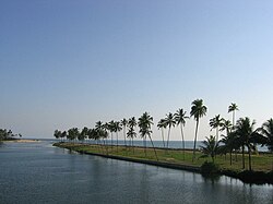
Kappil beach and backwaters in Edava
India Kerala location map.svg
Red pog.svg
Edava
Location in Kerala, India
India location map.svg
Red pog.svg
Edava
Edava (India)
Coordinates: 8°46′02″N76°41′24″E / 8.7671°N 76.6901°E / 8.7671; 76.6901
CountryFlag of India.svg  India
State Kerala
District Thiruvananthapuram
Taluk Varkala Taluk
Government
  Body Gram panchayat
Area
  Total
9.14 km2 (3.53 sq mi)
Population
 (2011)
  Total
25,994
  Density2,800/km2 (7,400/sq mi)
Demonym Edavakaran
Languages
  Official Malayalam, English
Time zone UTC+5:30 (IST)
PIN
695311
Telephone code0470
Vehicle registration KL-81
Nearest city Varkala
Literacy98.97%
Vidhan Sabha constituency Varkala
Loksabha Sabha constituency Attingal

Edava is a panchayat in Varkala Taluk, which is the northernmost tip of Thiruvananthapuram district in the state of Kerala, India. Edava is located 5km north of Varkala, 21km south of port city Kollam and 44km north of capital city Thiruvananthapuram. Kappil beach is a famous surf location.Surfsupkerala life saving club operates here.

Contents

History

In legends and myths related to Kerala, texts like the Kerala Mahatmyam describe the Varkala region as one of the sacred places of Kerala.

Edava was the frontier of the erstwhile Province of Travancore and Venad. This village is on the northwest boundary of Thiruvananthapuram district adjacent to the Arabian Sea and situated between two municipalities, Varkala to the south and Paravur to the north.

Edava along with Varkala and Navaikulam shares many cultural and linguistic similarities with the neighboring Kollam district or Central Travancore rather than the Trivandrum and Attingal regions.

The railway line between Trivandrum and Kollam passes through this village. Edava may be the only village in Kerala with two railway stations: Kappil and Edava. There is a road (TA Majeed Road) connecting Kollam and Thiruvananthapuram.

Edava has witnessed important historical events in Kerala. Historical references show that during the rule of Queen Umayamma one `Mughal Sardar' attacked Venad in the year 1680. His reign extended from the South of Thovala to Edava.

In the year 1726, Queen of Attingal gave permission to the British East Indian Company to build a Pandakasaala (warehouse) near what is now called Vettakkada, close to the Arabian Sea. But even before the setting up of this Pandakasaala, Denmark traders had constructed a trading hub over there. K P Padmanabha Menon, in his seminal work, Kerala History, has quoted English army captain Alexander Hamilton as saying that during the first leg of 18th century: "Here on the beach side, Denmark traders have a small warehouse with coconut-thatched roof. It is in a dilapidated condition. Their trading, likewise, is nominal." This location at Vettakkada is still named Paandiyala, a worn-out usage of Paandakasaala, which is the Malayalam for warehouse.

The first printing press in the erstwhile Travancore, or perhaps in Kerala, with facility to print in Arabic script, was established in Edava in 1936. It was called Coronation Memorial Press and was situated at what is now called Press Mukku. Its establishment coincided with the coronation ceremony of Travancore King. Orders for books, in Arabic, used to come from even far-flung places such as the present-day Pakistan.

Edava is the birthplace of late T A. Majeed, who was the PWD Minister in the first Communist Ministry of 1957. He was known for his impeccable political career minus any blemishes.

Edava's secular credentials are impeccable and sublime, with Hindus and Muslims living shoulder to shoulder without making any ripples in the placid social waters of this pristine coastal village. There is no wonder because the village is just a microcosm of a larger Kerala. Edavites, cutting across religious affiliations, are used to wake up to devotional songs from temples and call for prayers from mosques. Edavites, cutting across religious belief, enjoy major temple festivals in the village with all fervor and gaiety, without providing any room for nefarious communal elements to disturb this glorious tradition. Of particular mention is the temple festival of Palakkav Temple.

Geography

Kappil Beach & Estuary Kappil Estuary.JPG
Kappil Beach & Estuary
Arabian Sea view from the Redhills, Vettakada Arabian Sea view from the Redhills, Vettakada.jpg
Arabian Sea view from the Redhills, Vettakada

Demographics

As of 2001 India census, Edava had a population of 26,903, with 12,292 males and 14,611 females.

Transportation

The main road of Edava is TA Majeed Road, which connects Varkala to Paravur through Edava.

Edava has two railway stations, one is Edavai railway station and the other is Kappil railway station. Edava may be probably the only village in Kerala with two railway stations. The railway line which connects Thiruvananthapuram and Kollam passes through Edava.

The nearest main railway station is Varkala Railway Station which is having stops for almost 90% trains and it is the most important station between Thiruvananthapuram Central railway station and Kollam Junction railway station. Varkala Railway Station is just 3 km away from Edava.

The nearest airport is Thiruvananthapuram International Airport, 55 km from Edava.

Lakes

Edava-Nadayara Lake View from Varkala-Paravoor Road Bridge Edava Nadayara Lake.JPG
Edava-Nadayara Lake View from Varkala-Paravoor Road Bridge

Edava Nadayara lake and canal

Prominent people

Related Research Articles

<span class="mw-page-title-main">Attingal</span> Town in Kerala, India

Attingal is a municipality in Thiruvananthapuram metropolitan area in Thiruvananthapuram district of Kerala state, India. It was the location of the Attingal kingdom, under Travancore. It is the headquarters of Chirayinkeezhu Taluk, and the important government institutions of the taluk such as the Taluk office, court complex, office of the deputy superintendent of Police, civil station, and treasuries are situated in Attingal. It is one of the oldest municipalities of Kerala which was constituted prior to its independence in 1924. In 1914 itself Attingal Town Improvement Authority (TIA) was formed which was the term used before the municipality regulation act of 1922. Attingal Town is located 25 kilometres (16 mi) north of Thiruvananthapuram. Attingal is the 3rd densely populated municipality in the district.

<span class="mw-page-title-main">Varkala</span> Town in Kerala, India

Varkala is a major coastal municipality and a northern suburb of Thiruvananthapuram, the capital city of the Indian state of Kerala. In legends and myths related to Kerala, texts like the Kerala Mahatmyam describe the Varkala region as one of the sacred places of Kerala.

<span class="mw-page-title-main">Nedumangad</span> Municipality in Kerala, India

Nedumangad is a municipal town in the Thiruvananthapuram district in the Indian state of Kerala. It is the headquarters of Nedumangad Tehsil and Nedumangad Revenue Division. It is a suburb of the extended metropolitan region of Thiruvananthapuram. It is located around 16 km (9.9 mi) to the north-east of Thiruvananthapuram on the State Highway 2. It is an important commercial center in the district. It is a growing commercial and educational hub and all important government institutions are situated in the town. The Nedumangadu market has significance in southern Kerala.

Paravur is a municipality in the Kollam district of Kerala, India. Paravur is located 11.6 km (7.2 mi) southeast of the Kollam city centre, and is a part of the Kollam metropolitan area. Paravur railway station is the last station in Kollam district which is on the route to Trivandrum while travelling towards South India.

<span class="mw-page-title-main">Thiruvananthapuram district</span> District in Kerala, India

Thiruvananthapuram District is the southernmost district in the Indian state of Kerala. The district was created in 1949, with its headquarters in the city of Thiruvananthapuram, which is also Kerala's administrative centre. The present district was created in 1956 by separating the four southernmost Taluks of the erstwhile district to form Kanyakumari district. The city of Thiruvananthapuram is also known as the Information technology capital of the State, since it is home to the first and largest IT park in India, Technopark, established in 1990. The district is home to more than 9% of total population of the state.

The Main Central Road popularly known as MC Road is the arterial State Highway starting from Kesavadasapuram in Trivandrum city and ends at Angamaly, a suburb of Kochi city in Ernakulam District, in the state of Kerala, India. It is designated as State Highway 1 by the Kerala Public Works Department. The highway was built by Raja Kesavadas, Dewan of Travancore, in the 1790s. Plan for a new highway called Thiruvananthapuram–Angamaly Greenfield Highway, which runs parallel to the MC Road is proposed and is under early stage of development.

<span class="mw-page-title-main">Parippally</span> Village in Kerala, India

Parippally is a village in kalluvathukkal panchayat Kollam, Kerala, India. Parippally is 22 kilometres (14 mi) South of Kollam City along NH66 and 44 kilometres (27 mi) North of Thiruvananthapuram along NH66. Kollam Govt. Medical College is situated in Parippally. Varkala sivagiri is nearest major Railway station 12 km(7.5 mi).

<span class="mw-page-title-main">Kilimanoor</span> Town in Kerala, India

Kilimanoor is a panchayat and a town in the Chirayinkeezhu taluk of Thiruvananthapuram district in Kerala, India. It is located on MC/SH 1 Road, 33 kilometres (21 mi) North-west of the city of Thiruvananthapuram (Trivandrum), 14 km (8.7 mi) east of Attingal and 20 km (12 mi) east of Varkala.

The Thiruvananthapuram - Shoranur canal is a historic canal in India, from Trivandrum to Shoranur. It was one of the most arterial transportation mode in erstwhile Travancore princely state. Most of the trade, commerce and freight traffic in Travancore used to happen through this canal. The canal used to pass through rice bowl of the state, Kuttanad, centre of Coir trade i.e. Alappuzha, centre of Cashew business, Kollam, Changanassery market, strategic Thevally, Kayamkulam, Varkala etc. and used to connect Thiruvithamkoor with Cochin State and Malabar.

<span class="mw-page-title-main">Umayamma Rani</span> Regent of Venad

"Aswathi Thirunal" Umayamma, known as Queen Umayamma or Queen Ashure (Aswathi), (died 1698), was the regent queen of Venad (Venatu) in southern India from 1677 to 1684 on behalf of her young nephew (son of her older sister Senior Queen Makayiram Thirunal) Ravi Varma. She also served as the Junior Queen of Attingal under Senior Queen Makayiram Thirunal and subsequently as the Senior Queen of Attingal.

<span class="mw-page-title-main">Chirayinkeezhu</span> Taluk in Kerala, India

Chirayinkeezhu is a town in Thiruvananthapuram district in the Indian state of Kerala. It was also hometown of famous Malayalam Film actor Prem Nazir. It is the seat of Chirayinkeezhu taluk.

Kappil is a seashore tourist spot located in Thiruvananthapuram district, Kerala, India. Varkala railway station is the major railway station near Kappil.

Venjaramoodu is a north-east suburb of Trivandrum city, the capital of Kerala. It is 9 km (5.6 mi) east of Attingal, 11 km (6.8 mi) northwest of Nedumangad and 12 km (7.5 mi) northeast of Thiruvananthapuram City.

Varkala Sivagiri railway station is an NSG–3 category Indian railway station in Thiruvananthapuram railway division of Southern Railway zone. is a major railway station in Kerala serving the town of Varkala and northern areas of Thiruvananthapuram district. It is the second-busiest railway station in the state capital district Thiruvananthapuram in terms of passenger movement and 14th busiest in Kerala State. Around 54 trains halts in this station which handled more than 17,730 passengers daily with 3 platforms. It is on Kollam–Thiruvananthapuram trunk line. Station is well connected to major metropolitan & tier 2 cities like Thiruvananthapuram, Hyderabad, Kochi, Delhi, Bangalore, Mangalore, Chennai, Mumbai, Vijayawada, Kolkata, Goa etc.

<i>Vanchinad Express</i>

Vanchinad Express is an intercity express train running between Thiruvananthapuram and Ernakulam in the state of Kerala, India. It is operated by the Thiruvananthapuram division of the Southern Railway zone of the Indian Railways.

<span class="mw-page-title-main">Paravur railway station</span> Railway station in Paravur, Kollam

Paravur railway station is an NSG–5 category Indian railway station in Thiruvananthapuram railway division of Southern Railway zone. It is a railway station in the Indian municipal town of Paravur in Kollam district, Kerala. Paravur railway station was formerly a D-class railway station.

<span class="mw-page-title-main">Thekkumbhagam</span> Neighbourhood in Kollam, Kerala, India

Thekkumbhagam or Thekkumbhagom is the western coastal town of Paravur municipality in the Kollam district of Kerala, India. It is located at the South-western tip of Kollam's coastal area. It is in the Arabian Sea coast. Thekkumbhagam-Kappil estuary point in the Kollam-Thiruvananthapuram coastal border is one of the emerging tourism spots in the state. On 1936, during formation, Thekkumbhagam was one of the nine territories of Paravur Panchayath. Thekkumbhagam estuary is one among the twin estuary points in Paravur. The other one is Pozhikara estuary.

<span class="mw-page-title-main">Estuaries of Paravur</span> Group of Estuaries in Paravur, Kollam

The Paravur Estuaries are a group of estuaries in Paravur, India, near the South-Western coast of Kollam district, Kerala. Paravur is one among the 4 municipal towns in Kollam district, Kerala state. The place is known for its natural beauties, backwater locations, white-sand beaches and concentration of temples.

<span class="mw-page-title-main">Varkala Taluk</span> Taluk in Trivandrum district

Varkala Taluk is a Taluk (tehsil) situated in the northernmost tip of Thiruvananthapuram district in the Indian state of Kerala. It is the 3rd most densely populated taluk in the district comprising 10 villages and Varkala municipality. Spanning an area of about 171 km2,Varkala Taluk is home to over 9% of total population of Trivandrum district. Varkala is the taluk headquarters and the largest town of the taluk.

<span class="mw-page-title-main">Puthenkulam</span> Place

Puthenkulam is a small village in Ithikkara block in Kollam district of Kerala state, India. It comes under Poothakkulam Grama panchayath. Puthenkulam postal pincode is 691302. It is located 5 km from Paravur on Paravur - Parippally road. Puthenkulam is known as the 'elephant village' and is a popular tourist spot in Kollam. Approximate driving distance between Kollam railway station to Puthenkulam bus stop is about 22.1 km.

References