
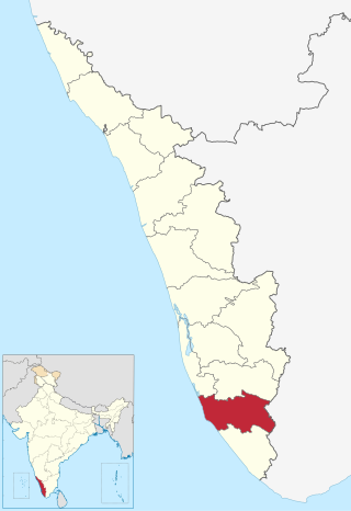
Wayanad is a district in the north-east of the Indian state of Kerala, with administrative headquarters at the municipality of Kalpetta. It is the only plateau in Kerala. The Wayanad Plateau forms a continuation of the Mysore Plateau, the southern portion of Deccan Plateau which links the Western Ghats with the Eastern Ghats. It is set high in the Western Ghats with altitudes ranging from 700 to 2,100 meters. Vellari Mala, a 2,240 m (7,349 ft) high peak situated on the trijunction of Wayanad, Malappuram, and Kozhikode districts, is the highest point in Wayanad district. The district was formed on 1 November 1980 as the 12th district in Kerala, by carving out areas from Kozhikode and Kannur districts. An area of 885.92 km2 in the district is forested. Wayanad has three municipal towns—Kalpetta, Mananthavady and Sulthan Bathery. There are many indigenous tribes in this area. The Kabini River, a tributary of Kaveri River, originates at Wayanad. Wayanad district, along with the Chaliyar valley in the neighbouring Nilambur in Malappuram district, is known for natural gold fields, which are also seen in other parts of the Nilgiri Biosphere Reserve. Chaliyar river, which is the fourth longest river of Kerala, originates on the Wayanad plateau. The historically important Edakkal Caves are located in Wayanad district.
Kollam district, is one of 14 districts of the state of Kerala, India. The district has a cross-section of Kerala's natural attributes; it is endowed with a long coastline, a major Laccadive Sea seaport and an inland lake. The district has many water bodies. Kallada River is one among them, and land on the east bank of the river is East Kallada and that on the west bank is West Kallada.
The administrative divisions of India are subnational administrative units of India; they are composed of a nested hierarchy of administrative divisions.
Pariyaram is a Grama Panchayat consisting of two villages viz. Pariyaram census town and Kuttiyeri village. Pariyaram is a suburb of Taliparamba on National Highway between Taliparamba and Payyanur in Kerala state of India. Mini villages of Thiruvattoor, Koran Peedika, Mukkunnu & Chithappile Poyil are parts of Pariyaram.
Aroor is a fishing village located within the northern border of the Alappuzha district in Cherthala taluk, Kerala, India. It lies on either sides of National Highway 66 and serves as a gateway between Kochi and Alappuzha. Aroor, surrounded by Vembanad, Kaithappuzha, and Kumbalangi backwaters, is known for its seafood export industry. The Aroor-Kumbalam Bridge is the second-longest bridge in Kerala.

Idukki is a township in Idukki district near to the district headquarter Painavu in the state of Kerala, southern India. The township consists of the towns of Cheruthoni, Painavu, Thadiyampadu, Idukki proper and Vazhathope. Idukki is an administrative town, but the district headquarters is located at Painavu.

Thiruvankulam is a census town and revenue village in Thrippunithura municipality, in Ernakulam district, Kerala, India. The area is a part of the Kochi metropolitan area. NH 85 passes through Thiruvankulam. The Karingachira junction is the location of the southern terminus of the Seaport-Airport Road, which connects the Cochin International Airport and the Cochin Port.

Anjarakandy is a census town and grama panchayat in Kannur district of Kerala, India. Anjarakandy river is flowing through Anjarakandy town.

Kizhakkambalam is an eastern suburb of the city of Kochi in Ernakulam district, Kerala, India. It is regarded as a model panchayat for its various development activities and is a part of the Kunnathunad tehsil of the Ernakulam district.

Pulingome is a village in Kannur District of Kerala state, India.

Kuttampuzha is a village and gram panchayat in Ernakulam district in the Indian state of Kerala. Situated 71 km east of Kochi, Kuttampuzha panchayat is home to the 17.7% of total area of the Ernakulam District.
Kannan Devan Hills is a large village located in Devikulam Taluk of Idukki District in the Indian state of Kerala. It is situated near the state border of Tamil Nadu about 25 kilometres northeast of the district seat Painavu and 8 kilometres north of the subdistrict seat Devikulam. In 2011, it was home to 55,738 residents.
Ayyankunnu is a village in Kannur district in the Indian state of Kerala.The name ayyankunnu came from the five hills "Anchu Kunnu".
Kadannapalli is a census town in Kannur district of Kerala state, India.

Karivellur is a census town and Gram Panchayat in Kannur district of Kerala state, India.

Kurumathur is a census town in Taliparamba taluk of Kannur district in Kerala state, India. Kurumathur is located 8 km (5.0 mi) east of Taliparamba town in SH 36.
Nedumpana is a grama panchayath in Kollam district in the state of Kerala, India. It is a part of Mukhathala Block Panchayath.

Kadapra is a village in the Thiruvalla subdistrict of Pathanamthitta district, Kerala state, India. It shares an intradistrict river border with Nedumpuram village separated along the Manimala river towards its north and an interpenetrating intradistrict land border with Niranam village towards its west.

The Malappuram Metropolitan Area or Malappuram Urban Agglomeration is an urban agglomeration centred around the city of Malappuram, Manjeri in Malappuram district, Kerala, India. It is the 25th largest urban agglomeration in India and the 4th largest in Kerala.
Kannur taluk is an administrative division of Kannur district of Kerala, India. Kannur district is divided into five taluks, Thalassery, Kannur, Payyanur, Iritty and Taliparamba. Thalassery has 35 villages, Kannur has 28, Payyanur has 22, Taliparamba has 28 villages and Iritty has 20 villages.


