Alappuzha district, is one of the 14 districts in the Indian state of Kerala. It was formed as Alleppey district on 17 August 1957, the name of the district being changed to Alappuzha in 1990. Alappuzha is the smallest district of Kerala. Alleppey town, the district headquarters, was renamed Alappuzha in 2012.
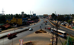
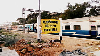
Cherthala is a municipality in the Alappuzha district of Kerala, India and act as satellite town of kochi. It is located 20 km (12.4 mi) north of the district headquarters in Alappuzha and about 146 km (90.7 mi) north of the state capital Thiruvananthapuram. As per the 2011 Indian census, Cherthala has a population of 45,821 people, and a population density of 2,727/km2 (7,060/sq mi).

Perumbavoor is a municipality in the Ernakulam district of Kerala, India. It is located 18 km (11.2 mi) north of the district collectorate in Thrikkakara and about 187 km (116.2 mi) north of the state capital Thiruvananthapuram. Perumbavoor is part of the Kochi metropolitan area and is located 26 km (16.2 mi) northeast of the Kochi city centre. As per the 2011 Indian census, Perumbavoor has a population of 28,110 people, and a population density of 2,065/km2 (5,350/sq mi).
Alappuzha, also known as Alleppey, is a municipality in the Alappuzha district of Kerala, India. It is the district headquarters of the district, and is located about 130 km (80.8 mi) north of the state capital Thiruvananthapuram. As per the 2011 Indian census, Alappuzha has a population of 240,991 people, and a population density of 3,675/km2 (9,520/sq mi).
Arookutty is a census town in Alappuzha district in the state of Kerala, India.

Muhamma is a census town in Cherthala Taluk in Alappuzha district in the Indian state of Kerala. It is home to Cheerappanchira kalari, where Lord Ayyappa of Sabarimala had his training in the martial arts. Cheerappanchira is an Ezhava ancestral home in Muhamma. Muhamma was the village where the Communist Party of India (Marxist) leader P. Krishna Pillai died after sustaining a snake-bite. Pathiramanal island, one of the scenic spots in vembanad lake is a part of Muhamma Panchyath.Muhamma boat jetty offers ferry services to Kumarakom and Alappuzha. Pathiramnal island can be accessed by private owned boats and also by government operated water transport.
Panavally is a village in India that is north part of Cherthala taluk and Alappuzha district in Kerala state. It is about 25 minutes(19 km) drive from Kochi city.

Vayalar is a village in Cherthala taluk, Alapuzha district, Kerala state, India.

Kuthiathode is a gram panchayat in Alappuzha district in the Indian state of Kerala. It is only 20 minutes away from Kochi city.
Thycattusserry is a village in the Cherthala taluk of the Alappuzha district in the Indian state of Kerala.
Eramalloor is a village in Ezhupunna Grama Panchayat in the Cherthala taluk in Alappuzha district in the Indian state of Kerala.
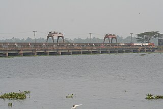
The Thanneermukkom Bund was constructed as a part of the Kuttanad Development Scheme to prevent tidal action and intrusion of salt water into the Kuttanad low-lands across Vembanad Lake between Thannermukkom on west and Vechur on east. Thanneermukkom Bund was constructed in 1974 and is functional since 1976. It is the largest mud regulator in India. This barrier essentially divides the lake into two parts - one with brackish water perennially and the other half with fresh water fed by the rivers draining into the lake.
Nettoor is a region in the city of Kochi. It is around 5 km (3.1 mi) from Vytilla Junction and around 8 km (5.0 mi) from Ernakulam Junction Railway Station. Nettoor is located on Panangad Island and is a part of Maradu Municipality.

Thuravoor is a gram panchayat in the Pattanakkad Block of Cherthala Taluk of the Alappuzha District, State of Kerala, India. It comes under Aroor Assembly constituency. Thuravoor lies under Kochi UA in future. A four lane(six lane is progressing) National Highway 66 passes through the village, which along with a railway station gives it excellent connectivity with the remainder of the state. The new 6 lane elevated highway is from Thuravoor to Aroor. Upon completion, it will become the longest elevated highway in the country. Thuravoor is a rapid developing town. It lies in Aroor Assembly constituency. Thuravoor Kumbalangi road is a main road parallel to NH 66. Thuravoor is the major entry to Kochi city.
Parayakad, Alappuzha is a village in Kuthiathode gram panchayat, India. in Cherthala Taluk in Alappuzha district in the Indian state of Kerala. There is another place known as Parayakad or Parayad in Ernakulum District. This is a small area / block (muri) in Chittattukara Village in North Paravoor. Parayakad Village in Alleppey district is listed in the Central Government Indian Village Directory. Kuthiathode comes under the Pattanakad Block in Aroor Assembly constituency.
Pallithode is a village in the Alappuzha district, in the state of Kerala, India, on the shores of the Arabian Sea. Pallithode is within the Gram Panchayat of Kuthiathode, Pattanakad Block, of Cherthala Taluk. During the 20th century, more than half of its width was eroded away by the action of river backwaters and the sea. The village is very densely populated and has a wet, maritime tropical climate. It has an important role in the fishing industry.
Ernakulam–Kayamkulam coastal line is a railway line which runs along the coastal areas of Alappuzha, Ernakulam districts in Kerala state of India. The coastal railway line starts as a branch line from Ernakulam Junction railway station towards Alappuzha and joins with the route via Kottayam at Kayamkulam Junction. This is the only main track in Kerala yet to be doubled and the single line traffic causes major delays in the route. The coastal line has a total distance of 102 km (63 mi).
The following are some of the industries in Cherthala, Kerala, India.
Alappuzha District has four types of administrative hierarchies: