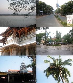
Kundapur also called Kundapura, is a coastal town situated in the Udupi district of the state of Karnataka, India. Kundapura also called richest town and taluk of Karnataka state, India.This town was known as Coondapoor while it was part of the erstwhile South Canara district (1862–1947) of the Madras Presidency of British India. Present-day Kundapur is administered by the Kundapur Town Municipal Council and serves as the headquarters of the Kundapur Taluk of Udupi district.

Godhra is a municipality in Panchmahal district in Indian state of Gujarat. It is the administrative headquarters of the Panchmahal district. Originally the name came from gou which means "cow" and dhara- which have two meanings depending on how you pronounce the word: 'dharaa' means a feminine thing or person that "holds" something and it usually means"land", and the other pronunciation is 'dhaaraa' in which means "flow". However, the second pronunciation is not popular nor is usually associated with this word. Hence, 'Godhra or Godharaa' means the Land of the Cow.
New Tehri is a city and a municipal board in Tehri Garhwal District in the Indian state of Uttarakhand. It is the administrative headquarters of Tehri Garhwal District. This urban municipality area has 11 wards, from Vidhi Vihar to Vishwakarma Puram. Mrs Seema Krishali is the chairperson of Nagar Palika Tehri, and is the first female chairperson of Tehri. She won as an independent. Shri Umesh Gusain of the BJP was Chairman of the Tehri Nagarpalika before Mrs Seema Krishali. He is the only Chairman who won this seat two times consecutively in 61 years. Tehri is represented by the Tehri assembly seat of Uttarakhand and the Tehri Lok Sabha seat of India, which are represented by Dhan Singh Negi and Mala Rajya Laxmi Shah respectively.
Vilathikulam is a selection grade panchayat town in Thoothukudi district in the Indian state of Tamil Nadu. It is a small town near the southern tip of mainland India.
Thirunindravur is a neighbourhood situated on the western part of Chennai, Tamil Nadu, India. It is located around 29 km from Chennai Central railway station. Thirunindravur comes under Chennai Metropolitan Area. The neighbourhood is served by Thirunindravur railway station. It is famous for its temples. The Tiruninravur lake serves the neighbourhood for its water needs.
Aroor is a census town at the northern end of Alappuzha district and the southern suburb of the city of Kochi in the state of Kerala, India. It is a seafood related industrial area of Alleppey district, and acts as the Southern entry point into Kochi city.
Brahmakulam is a census town in the Thrissur district in the state of Kerala, India.
Chhachhrauli is a tehsil and Gram Panchayat town consisting of 20 wards in Yamuna Nagar district in the state of Haryana, India. It is 11 km north-east of Jagadhari. Chachhraulli is often known as "Cherapunjii of Haryana" as it receives the most rain in the whole of Haryana and Punjab. It was a municipal committee until 1998. Before independence in 1947, it was the capital of the princely state of Kalsia. The origin of word Chhachhrauli is believed to be "Sat Sherawali" due to a temple located near bus terminus.
Kannapurampronunciation (help·info) is a census town in Kannur district of North Malabar region in the Indian state of Kerala.

Krishnarajapuram, officially Krishnarajapura, is neighborhood of Bangalore in the Indian state of Karnataka. It is one of the zones of BBMP. It is located 15 km (9.3 mi) from Bangalore City railway station. Old Madras Road passes through Krishnarajapuram. A lake called 'Vengayyana Lake' is in the heart of this area. The Yele Mallappa Shetty Lake near Medahalli, situated just outside the eastern limits of KR Puram, is one of the largest lakes in Bangalore.
Lambha is a census town in Ahmadabad district in the Indian state of Gujarat.
Madathukulam is Border to Dindigul District in Tirupur district in the Indian state of Tamil Nadu.

Maniyar is a town and a Nagar Panchayat in Ballia district in the Indian state of Uttar Pradesh. It is also called Parshuram Nagari.
Minjur is a town located in the outskirts of North Chennai, India. It is located in the Thiruvallur district in the Indian state of Tamil Nadu. Minjur is called 'Vada Kanchi' meaning North Kanchipuram. The town has two famous temples for Shiva and Vishnu, similar to Kanchipuram. The neighbourhood is served by Minjur railway station of the Chennai Suburban Railway Network.
Pannaipuram is a panchayat town in Theni district in the Indian state of Tamil Nadu. It is located hill foot of "Western Ghats" sharing its border with Kerala State and has very good literacy. Pannaipuram Town panchayat includes 4 villages namely Pannaipuram, Kariyanampatty, Mallingapuram and P. Renganathapuram. Mahalingeswarar Temple, Kaliamman Temple and Bommaiyaswamy Temple are located in Pannaipuram. Veereswarar Temple is located in Kariyanampatty. Most of the people in Pannaipuram are engaged in Cardamom cultivation and trade in nearby Kerala hills.
Thenkarai is a suburban area near Coimbatore City Municipal Corporation, in the Indian state of Tamil Nadu. It is in the western suburbs of Coimbatore. It recently merged with the Coimbatore Corporation limits. Thenkarai is one of the town panchayats in Coimbatore and consists of small villages such as Sennanur, Mathipalayam, Karadimadai, Thaneer Panthal, Appachimaar Kovil, Challikkuzhi and KrishnaPuram Pudur.

Thiruvankulam is a suburb of the city of Kochi, in the state of Kerala, India. It is a part of Tripunithura Municipality and Kochi metropolitan area. In the days of the Kochi and Travancore kingdoms, Thiruvankulam was a border village. The Kavaleeshwaram stream, now a canal, separated the two kingdoms. The Kochi - Madurai National Highway passes through Thiruvankulam. It is a major fork junction on the highway from Kochi, going east towards Muvattupuzha and south towards Kottayam. Karingachira serves as a terminus of the Airport–Seaport road connecting Nedumbaseery and the Kochi port.
Vadipatti is a panchayat town in the Madurai district in the Indian state of Tamil Nadu. Population of the town is 21,833. The famous Festival for Bull are "Jallikattu","Manju virattu" or "Erudhukattu Vizha". The major "Jallikattu Protest" happened in the surroundings of this town.
Koipuram is a large census village in Tiruvalla, Pathanamthitta district in the state of Kerala, India. Kumbanad, Muttumon, Pullad, Poovathoor, are the nodal points. The village has large number of banks and Christian churches. The Koipuram area has a sizeable NRI population, like other parts of Tiruvalla, and this is the main source of economy. Many nationalised and private banks have their branches in Koipuram, especially in the Kumbanad area. This is a well developed region, thanks to the NRI population. Village with beautiful cultural of agriculture, religious traditions and equality.
