
Alappuzha district, is one of the 14 districts in the Indian state of Kerala. It was formed as Alleppey district on 17 August 1957, the name of the district being changed to Alappuzha in 1990. Alappuzha is the smallest district of Kerala. Alleppey town, the district headquarters, was renamed Alappuzha in 2012.
Mavelikara is a municipality in the Alappuzha district of Kerala, India. It is located 36 km (22.4 mi) south of the district headquarters in Alappuzha and about 95 km (59.0 mi) north of the state capital Thiruvananthapuram. As per the 2011 Indian census, Mavelikara has a population of 26,421 people, and a population density of 2,088/km2 (5,410/sq mi).

Aranmula is a temple town in the state of Kerala, India. It is known as the cultural capital of Pathanamthitta district, located at a distance of around 116 km from Trivandrum, the capital of Kerala, it is situated on the banks of the river Pampa. A centre of pilgrimage from time immemorial and a trade post of eminence, when the river was the chief means of transport, it is near Kozhencherry in Pathanamthitta District. It is easily accessible from Chengannur railway station (10km). It is one of the Fastest Growing Village. Aranmula, along with the majority of Pathanamthitta district, was part of the Quilon division or Central Travancore division of Travancore. On November 1, 1982, Pathanamthitta district was established.
Odanad was a feudal state in late medieval Kerala. It was established in the 11th century, and disestablished in 1746 when it became part of Travancore after Venad King Marthanda Varma's northern expedition. The last king of Odanad was King Kotha Varma. At the time of its dissolution, it was composed of the present-day taluks of Mavelikkara, Karthikapally, Chenganur in the Alappuzha district and Karunagapally in the Kollam district. Pure Malayalam is spoken by Onattukara/kayamkulam peoples. Other name of onattukara is kayamkulam. In the 15th century, the capital of Odanad was moved from Kandiyoor-Muttom, Mavelikkara to Eruva and Krishnapuram, near Kayamkulam, which led to the state being called Kayamkulam. After this shift, Kayamkulam became the commercial centre of Odanad, while Mavelikkara remained its cultural centre. Odanad was controlled by Nair lords, among whom the ruler of Kayamkulam was the most prominent.

Pandalam is a municipality in the Pathanamthitta district of Kerala, India. Pandalam is known for its connection with Ayyappan and Sabarimala. It recognised as the cultural capital of Travancore, Pandalam hosts educational institutions ranging from reputed schools to post graduate, training, Ayurveda, and engineering colleges. There are seven colleges and 23 schools at Pandalam, including N. S. S. College, Pandalam. The Kerala state government plans to make the place a special Township, by including the Pandalam municipality and Kulanada panchayat.
Kayamkulam is a municipality in the Alappuzha district of Kerala, India. It is located 90 km (55.9 mi) south of the district headquarters in Alappuzha and about 98 km (60.9 mi) north of the state capital Thiruvananthapuram. As per the 2011 Indian census, Kayamkulam has a population of 68,634 people, and a population density of 3,149/km2 (8,160/sq mi).
Adoor is a municipality in the Pathanamthitta district of Kerala, India. It is the headquarters of the Adoor Taluk and Adoor Revenue Division. Adoor is located 18 km (11.2 mi) southwest of the district headquarters Pathanamthitta and 85 km (52.8 mi) north of the state capital Thiruvananthapuram.
The Main Central Road popularly known as MC Road is the arterial State Highway starting from Kesavadasapuram in Trivandrum city and ends at Angamaly, a suburb of Kochi city in Ernakulam District, in the state of Kerala, India. It is designated as State Highway 1 by the Kerala Public Works Department. The highway was built by Raja Kesavadas, Dewan of Travancore, in the 1790s. Plan for a new highway called Thiruvananthapuram–Angamaly Greenfield Highway, which runs parallel to the MC Road is proposed and is under early stage of development.

Chengannur is a municipality in the Alappuzha district of Kerala, India. It is located 37 km (23.0 mi) south of the district headquarters in Alappuzha and about 98 km (60.9 mi) north of the state capital Thiruvananthapuram. As per the 2011 Indian census, Chengannur has a population of 23,466 people, and a population density of 1,607/km2 (4,160/sq mi).

Pathanamthitta, is a municipality situated in the Southern Kerala, India, spread over an area of 23.50 km2. It is the administrative capital of Pathanamthitta district. The town has a population of 37,538. The Hindu pilgrim centre Sabarimala is situated in the Pathanamthitta district; as the main transport hub to Sabarimala, the town is known as the 'Pilgrim Capital of Kerala'. Pathanamthitta District, the thirteenth revenue district of the State of Kerala, was formed with effect from 1 November 1982, with headquarters at Pathanamthitta. Forest covers more than half of the total area of the District. Pathanamthitta District ranks the 7th in area in the State. The district has its borders with Allepey, Kottayam, Kollam and Idukki districts of Kerala and Tamil Nadu. Nearest town is Thiruvalla, located at a distance of 30 km. Thiruvalla railway station is 30 km via Thiruvalla-Kumbazha highway. Buses ply every 5 Minutes from Thiruvalla To Pathanamthitta & vice versa.
Kallissery is a small town in Chengannur Taluk of Alappuzha district of Kerala, India.
Oachira Temple is an ancient temple located in Oachira in Kollam district in the South Indian state of Kerala. According to the Puranas, this temple is one of the famous sacred places of Kerala and India. Oachira is on the border of Kollam and Allappuzha districts, next to the National Highway 66. This temple is known "DakshinaKashi"(SouthaKashi).This very ancient pilgrimage center is centered on the ParaBrahma temple, and covers thirty-six acres of land.

Konni, also spelt Konny, is a town and taluk headquarters in Pathanamthitta district of Kerala, India. Konni is known for its elephant cages, forests, and rubber plantations. It is also known as "Aanakoodinte Nadu". Nearest town is Pathanamthitta. Konni is located 32 km (20 mi) from Chengannur railway station and NH 183 in Chengannur. It is well-connected via Muvattupuzha - Punalur state highway. Buses ply frequently from Pathanamthitta KSRTC bus station to Konni.
Padanilam is a town located in Onattukara region of Alappuzha district, Kerala. The word Padanilam means "land of battles". It is located on the banks of river Achankovil. The Padanilam temple is one of the important centres of worship in Kerala. Nooranad is named as the Nandikesha Paithruka Gramam by the Government of Kerala due to its importance in kettukala construction, which is an icon of Onattukara region.

Kodukulanji is a village located around 5 km north of the Achankovil River and 7 km south of the Pamba River, in Alappuzha district.

Elavumthitta is a town in Pathanamthitta district of Kerala, India. The majority of its inhabitants are from Hindu and Christian backgrounds. The primary crops are rubber, coconut, black pepper and plantain. The terrain is hilly with plenty of paddy fields in between. It is the commercial centre of Mezhuveli and Chenneerkara panchayaths.

Nooranad is a developing town in Mavelikkara taluk of Alappuzha district in the Indian state of Kerala. It is located at a distance of 8 Km south-west of Pandalam, in Kayamkulam route. Padanilam is the cultural centre of Nooranad region. The Padanilam Parabrahma Temple, known for the biggest Shivarathri Kettukazhcha in Kerala, is situated in Nooranad. Nooranad is declared by the Government of Kerala as the Nandikesha Paithruka Gramam due to its importance in Kettukala making, which is an icon of Onattukara region of Central Travancore. Nooranad is also known as Pakshi Gramam of kerala.

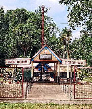
Padanilam Parabrahma Temple is situated at Padanilam in Mavelikara taluk of Alappuzha district in Kerala, India. It is one of the major temples in erstwhile Travancore state. Padanilam is the cultural center of Nooranad region. The temple is situated 17 km east of Kayamkulam and 7 km south west of Pandalam. The temple is dedicated to Lord Parabrahma, also known as omkaram.
Mundankavu is a village situated 2 kilometres (1.2 mi) from Chengannur town centre in Alappuzha district, Kerala, India. It lies on the banks of the river Pampa. It is known as Vadakekkara which is situated on the northern banks of River Pampa. Mundancavu(Mundankavu) ward is part of Chengannur Municipal town.

Nariyapuram is a village in Vallicode Panchayat of Pathanamthitta district in Kerala, India. Nariyapuram is located in the northern part of Pathanamthitta. Pandalam, which is seven km away is the nearest town. The district headquarters Pathanamthitta is eight km away. There are regular bus services via Nariyapuram. Schools, hospitals, places of worship and all other necessities are also available. The population here is not too large. There are vast areas of paddy fields and most of the villagers are farmers. Borders of Nariyapuram are Thattayil along the south, Thumpamon along the west, Achankovil river along the north and Kaipattoor along the east. One of the existing sugarcane cultivation in Central Travancore is in Nariyapuram.


