
Alappuzha is one of the 14 districts in the state of Kerala in India.It is the smallest district in Kerala. It was formed as Alleppey District on 17 August 1957. The name of the district was officially changed to Alappuzha in 1990. Alleppey town was renamed Alappuzha in 2012, even though the anglicised name is still commonly used to describe the town as well as the district. The district is best known for its picturesque backwaters.
Kottayam is one of fourteen districts in the state of Kerala, India. Kottayam district comprises of six municipal towns: Kottayam, Changanassery, Pala, Erattupetta, Ettumanoor, and Vaikom. It is the only district in Kerala that does not border the Arabian Sea or any other states.

Kumarakom is a popular tourism destination located near the city of Kottayam, in Kerala, India, famous for its backwater tourism. It is set in the backdrop of the Vembanad Lake, the largest lake in the state of Kerala.

Vallam Kali is a traditional boat race in Kerala, India. It is a form of canoe racing, and uses paddled war canoes. It is mainly conducted during the season of the harvest festival Onam in spring. Vallam kali includes races of many kinds of paddled longboats and 'snake boats'. Each team spends about 6 lakh rupees for the Nehru Trophy.

The Kerala backwaters are a network of brackish lagoons and lakes lying parallel to the Arabian Sea coast of Kerala state in southern India, as well as interconnected canals, rivers, and inlets, a labyrinthine system formed by more than 900 kilometres (560 mi) of waterways, and sometimes compared to American bayous. The network includes five large lakes linked by canals, both man made and natural, fed by 38 rivers, and extending virtually half the length of Kerala state. The backwaters were formed by the action of waves and shore currents creating low barrier islands across the mouths of the many rivers flowing down from the Western Ghats range. In the midst of this landscape there are a number of towns and cities, which serve as the starting and end points of backwater cruises.
Vembanad is the longest lake in India,and the largest lake in the state of Kerala[Mangrove with area 2114 sq. Km is the second largest Ramasar site in India only after Sunderbans in West Bengal] Spanning several districts in the state of Kerala, it is known as Vembanadu Lake in Kottayam, Punnamada Lake in Alappuzha and Kochi Lake in Kochi. Several groups of small islands including Vypin, Mulavukad, Vallarpadam, Willingdon Island are located in the Kochi Lake portion. Kochi Port is built around the Willingdon Island and the Vallarpadam island.

Ashtamudi Lake, in the Kollam District of the Indian state of Kerala, is the most visited backwater and lake in the state. It possesses a unique wetland ecosystem and a large palm-shaped water body, second only in size to the Vembanad estuary ecosystem of the state. Ashtamudi means 'eight braids' in the local Malayalam language. The name is indicative of the lake's topography with its multiple branches. The lake is also called the gateway to the backwaters of Kerala and is well known for its houseboat and backwater resorts. Ashtamudi Wetland was included in the list of wetlands of international importance, as defined by the Ramsar Convention for the conservation and sustainable utilization of wetlands.

Kuttanad is a region covering the Alappuzha, Kottayam and Pathanamthitta Districts, in the state of Kerala, India, well known for its vast paddy fields and geographical peculiarities. The region has the lowest altitude in India, and is one of the few places in the world where farming is carried on around 1.2 to 3.0 metres below sea level. Kuttanadu is historically important in the ancient history of South India and is the major rice producer in the state. Farmers of Kuttanad are famous for Biosaline Farming. Food and Agriculture Organization (FAO) has declared the Kuttanad Farming System as a Globally Important Agricultural Heritage System (GIAHS).

Alappuzha, also known by its former name Alleppey, is the administrative headquarters of Alappuzha District in the Indian State of Kerala. Alappuzha is a city and a municipality in Kerala with an urban population of 174,164 and ranks third among the districts in literacy rate in the State of Kerala. In 2016, the Centre for Science and Environment rated Alappuzha as the cleanest town in India. Alappuzha is considered to be the oldest planned city in this region and the lighthouse built on the coast of the city is the first of its kind along the Laccadive Sea coast.

Kainakary is a village in Kuttanad Taluk in Alappuzha District of the Indian state of Kerala.

Kottayam is a city in the Indian state of Kerala. Kottayam literally means the interior of a fort—Kotta + Akam. Flanked by the Western Ghats on the east and the Vembanad Lake and paddy fields of Kuttanad on the west, Kottayam is a place that is known for extraordinary qualities. It is the district headquarters of Kottayam district, located in south-west Kerala. Kottayam is located in the basin of the Meenachil River at an average elevation of 3 metres (9.8 ft) above sea level, and has a moderate climate. It is located 150 kilometres (93 mi) north of the state capital Thiruvananthapuram.
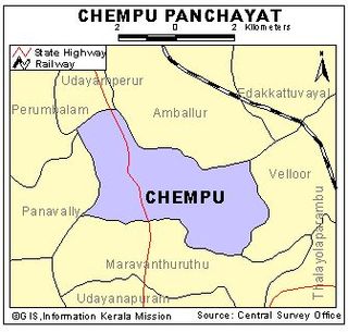
Chempu is a village near Vaikom in Kottayam, Kerala, India. It is bounded by the shores of the Lake Vembanad, and is crossed by various distributaries of the River Muvattupuzha.

Kumarakom Bird Sanctuary is situated at Kumarakom in Kottayam taluk of Kottayam district in the Indian state of Kerala, on the banks of Vembanad Lake. Set in the Kerala Backwaters, the bird sanctuary is a favourite haunt of migratory birds.

Thycattusserry is a village in the Cherthala taluk of the Alappuzha district in the Indian state of Kerala.
Manimala River is a 92 km long river in South and Central Kerala. The river used to be wrongly considered as a tributary of Pamba River before satellite maps became popular, but this is incorrect. Manimala does not flow into Pamba, but a branch of Pamba flows into Manimala from Kuthiathode and joins Manimala at Kallunkal, later branches out at again from Manimala at Nedumpuram and flows through Niranam, Thalavady, Edathua, Changankary, Champakulam, Nedumudy, Chennamkary, and finally Kainakary and empties into Vembanad lake. This branch again links with Manimala river at Chennankary in a short, but broad connection known as Munnattumukham. Manimala is a separate independent river for all geographical purposes. It has its origin on the Muthavara Hills on the Western Ghats, It is with a length of about 90 km and a catchment area of about 847 km2. in Idukki district of Kerala, India. The river passes through the districts of Kottayam, Pathanamthitta and Alappuzha districts. Yendayar, Koottickal, Mundakayam, Erumeli, Manimala, Kottangal, Kulathurmoozy, Vaipur, Mallappally, Keezhvaipur, Thuruthicad, komalam,/kuranjoor kadavuKallooppara, vallamkulam, Kattode & Kuttoor, Pulikeezh, Nedumpuram, Neerettupuram, Amichakary, Muttar, Kidangara, Pulincunnoo, Veliyanadu, Ramankary, Mankompu lie on the banks of Manimala River. Manimala splits after Kidangara into two branches. Second branch flows via Kunnamkary, Kavalam and Kainakary to Vembanad lake. Its running length is estimated at 92 km. It empties itself into the Vembanad Lake. It is one of the four major rivers which do not have direct outlet to sea as these rivers empty into the vast Vembanad lake. This huge lake has just two outlets, one at Thottappaly Spillway and second at Thannermukkom Bund, both man made barriers, built to prevent incoming seawater during high tides, which otherwise would render the low lying paddyfields uncultivable.

Azhuthayar is a tributary of the Pamba River, the third longest river in the South Indian state of Kerala. It originates from Peerumedu, flows through dense forests and reaches Koruthodu. From there it forms the boundary between Kottayam and Idukki districts. It then crosses Sabarimala traditional trekking path at Kalaketti area before joining with Pamba river at Kanamala(Pambavalley). Like its parent river, it is also closely related to the legend of Lord Ayyappan, a popular Hindu deity worshipped mainly in Kerala. It flows through a place also named Azhutha, which is on the Sabarimala trek route from Erumeli to Sabarimala. The river Pamba, ultimately flows around 180 kilometres (112 mi) through towns and villages Ranni, Cherukolpuzha, Maramon, Aranmula, Chengannur, Parumala, Neerettupuram, Kavalam, Nedumudi and Thakazhi before joining Vembanad lake.

Munroturuttu railway station or Mundrothuruthu railway station(Code:MQO) is an 'HG 2 Category' halt railway station, situated in between Perinad and Sasthamkotta railway stations of Kollam district in Kerala state, India. The station is coming under the Southern Railway Zone of Indian Railways. The nearest major rail head of Munrothuruthu railway station is Kollam Junction railway station.

Kollam KSWTD Boat Jetty or Kollam KSWTD Ferry Station is an transport hub in the city of Kollam in Kerala, India, one of 14 ferry stations owned by the Kerala State Water Transport Department.

Kannetty is a village situating in the outskirts of Karunagappally, Kollam district, Kerala state, India. Kannetty is famous for the Vallam kalis conducted in the backwater of the same name.
Waterways have always been an important mode of transport in Kerala. The total length of navigable route in Kerala was 1,900 kilometres and the navigable rivers constitute about 54 per cent of the waterways. The 41 West-flowing rivers together with the backwaters are an integrated part of the inland navigation system in Kerala. In Kerala water transportation through these channels are mainly small distant passenger services, informal country boats,freight transportation to PSU's such as Fertilisers and Chemicals Travancore, Kochi etc.
