Mavelikkara

Last updated

Mavelikara
Mavelikara station 03.jpg
Mavelikara Railway Station
India Kerala location map.svg
Red pog.svg
Mavelikara
Location in Kerala, India
India location map.svg
Red pog.svg
Mavelikara
Mavelikara (India)
Coordinates: 9°16′01″N76°33′00″E / 9.267°N 76.55°E / 9.267; 76.55
CountryFlag of India.svg India
State Kerala
District Alappuzha
Named for Mahabali
Government
  Type Taluk
  BodyMunicipal Council
  MP Kodikunnil Suresh
  MLAM S Arun Kumar
Area
  Total12.65 km2 (4.88 sq mi)
Population
 (2011) [1]
  Total26,421
  Density2,100/km2 (5,400/sq mi)
Languages
  Official Malayalam, English
Time zone UTC+5:30 (IST)
PIN
690101
Telephone code+91-479
Vehicle registration KL-31
Nearest cities Alappuzha (43 km)

Kottayam (44 km)

Kollam (50 km)
Literacy92.3%
Website www.mavelikaramunicipality.in
Vathikulam Devi temple Vathikulam.jpg
Vathikulam Devi temple
CSI Christ Church Crist church mavelikara.JPG
CSI Christ Church
Kandiyoor Sree Mahadeva Temple KANDIYUR TEMPLE EAST TOWER.jpg
Kandiyoor Sree Mahadeva Temple
mattom Padippura Mattam narasimha padippura.JPG
mattom Padippura
Mullikulangara temple Mulli temple.JPG
Mullikulangara temple
Chettikulangara Bhagavathy temple Chettiku temp.JPG
Chettikulangara Bhagavathy temple

Mavelikara is a taluk and municipality in the Onattukara region of Alappuzha district in the Indian state of Kerala. Located in the southern part of the district on the banks of the Achankovil River. [2]

Contents

Etymology

The name Mavelikara is believed to be turned out from the words Maveli or Mahabali, the mythical king of Kerala, and Kara means land. This land is believed to be the place 'Mattom Mahadeva temple'where king Mahabali knelt before Vamana, offering his head for Vamana to keep his feet.[ citation needed ]

Background

The town boasts about a rich historical and cultural background. The Chettikulangara Devi Temple, known for the Kumbha Bharani festival is located near the municipality. The place is home to one of the 108 Shiva temples of Kerala created by Lord Parashurama, the Kandiyoor Mahadeva Temple. It was also a major centre of trade and commerce in ancient Kerala and the erstwhile capital of the rulers of Onattukara. As a result of the close association with the Travancore Royal Family, Mavelikkara gained modern facilities well ahead of other places in the state. It is one of the oldest municipalities of the state. Even before India attained independence, Mavelikara had a super express transport service to Trivandrum.[ citation needed ]

Demographics

As of 2011 Census, Mavelikara had a population of 26,421 with 12,070 males and 14,351 females. Mavelikara Municipality has an area of 12.65 km2 (4.88 sq mi) with 7,184 families residing in it. The average female sex ratio was 1189 higher than the state average of 1084. 7.7% of the population was under 6 years of age. Mavelikara had an average literacy of 96.9% higher than the state average of 94%: male literacy was 97.8% and female literacy was 96.2%. [3]

YearMaleFemaleTotal PopulationChangeReligion (%)
HinduMuslimChristianSikhsBuddhistJainOther religions and persuasionsReligion not stated
2001 [4] 284391350614933-70.940.9828.020.000.020.000.000.04
2011 [5] 264211207014351-7.10%72.221.0426.490.020.020.000.050.17

Transport

Bus

Kerala State Road Transport Corporation has a sub depot at Mavelikkara (Station Code: MVKA) which is one among the 46 sub depots in the state. The KSRTC sub depot at Mavelikkara has an inter state bus service which is operated to Tenkasi every day; 2 trips morning & evening via Kayamkulam, Kattanam.

The Municipal Private bus stand is located at Mitchel Junction with buses to Chengannur, Pathanamthitta, Adoor, Pandalam, Thiruvalla, Haripad, Kayamkulam, Changanassery.

Rail

Main article : Mavelikara railway station

Mavelikara railway station (Station Code:MVLK) is a mainline station in the Trivandrum Division of the Southern Railway Zone (India), with connections to New Delhi, Mumbai, Chennai, Kolkata, Bangalore, Hyderabad, Ahmedabad, Pune, Mangalore, Bhopal, Guwahati, Nagpur and Jammu. Other nearby stations are Kayamkulam Junction railway station, Chengannur Railway Station, Haripad railway station and Kollam Junction railway station.

Air

The nearest airports are Trivandrum International Airport115 km and Cochin International Airport (CIAL).127 km State highway SH 10 road start in mavelikara

Economy

Local industries in and around Mavelikkara include:

Several small-scale industries are present in the Industrial Estate (an initiative of SIDCO) located at Kollakadavu.

Politics

Lok Sabha

Mavelikara has its own constituency in the Lok Sabha. [7] Until the 2002 Lok Sabha Delimitation took effect in 2008, the constituency consisted of Chengannur, Mavelikara, Kayamkulam, Pandalam, Thiruvalla and Kallupara. Since then, the assembly constituencies have comprised Changanassery, Kuttanad, Mavelikara (SC), Chengannur, Kunnathur (SC), Kottarakkara and Pathanapuram. The constituency is now reserved for a scheduled caste candidate.[ citation needed ]

Kodikunnil Suresh of the INC has represented the Mavelikkara constituency since 2009.

State Assembly

M.S Arunkumar from the CPI(M) is the representative of Mavelikkara in the Kerala Legislative Assembly.

Culture

The cultural capital of Alappuzha is Mavelikkara. Mavelikara was once part of the principality of Onattukara and has been a centre of religious harmony, culture and arts for several centuries.[ citation needed ]

As a testament to its link to that flourishing centre of Buddhist culture, Mavelikkara is one of the rare places in Kerala where one can find the Statue of Buddha in Seated Position, which dates back to the 9th century AD. [8] Mar Ivanios, the pioneer of the Reunion Movement is from this holy socio-cultural land. He is from the Medayil Panicker Family situated at the center of the Mavelikara Town.

Notable people

Places of worship

Educational organizations

Hospitals

See also

Related Research Articles

<span class="mw-page-title-main">Alappuzha district</span> District in Kerala, India

Alappuzha district, is one of the 14 districts in the Indian state of Kerala. It was formed as Alleppey district on 17 August 1957, the name of the district being changed to Alappuzha in 1990. Alappuzha is the smallest district of Kerala. Alleppey town, the district headquarters, was renamed Alappuzha in 2012, even though the anglicised name is still commonly used to describe the town as well as the district.

<span class="mw-page-title-main">Maramon</span> Village in Kerala, India

Maramon is a small village on the Pampa River, in Thiruvalla Sub-District & Taluk of Pathanamthitta district in the state of Kerala, India. The nearest railway station is Chengannur (13 km). Maramon is about 16 km from the Thiruvalla Town headquarters, the town of Thiruvalla The M. K. Road connects the town to other major towns.

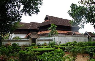
Odanad was a feudal state in late medieval Kerala. It was established in the 11th century, and disestablished in 1746 when it became part of Travancore after Venad King Marthanda Varma's northern expedition. The last king of Odanad was King Kotha Varma. At the time of its dissolution, it was composed of the present-day taluks of Mavelikkara, Karthikapally, Chenganur in the Alappuzha district and Karunagapally in the Kollam district. In the 15th century, the capital of Odanad was moved from Kandiyoor-Muttom, Mavelikkara to Eruva and Krishnapuram, near Kayamkulam, which led to the state being called Kayamkulam. After this shift, Kayamkulam became the commercial centre of Odanad, while Mavelikkara remained its cultural centre. Odanad was controlled by Nair lords, among whom the ruler of Kayamkulam was the most prominent.
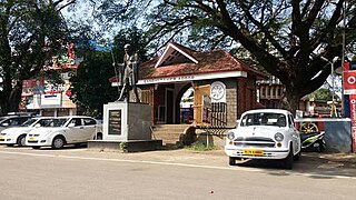
<span class="mw-page-title-main">Kayamkulam</span> Town in Kerala, India

Kayamkulam is a town and municipality in the Onattukara region of Alappuzha district in Kerala. It is the second biggest town in Alappuzha district. It is located on the western coast of India, and was an ancient maritime trading center.Kayamkulam is part of the Karthikappally tehsil. Krishnapuram Palace is located nearby.

<span class="mw-page-title-main">Alappuzha</span> City in Kerala, India

Alappuzha or Alleppey is the administrative headquarters of Alappuzha district in the state of Kerala, India. The Backwaters of Alappuzha are one of the most popular tourist attractions in India which attracts millions of domestic and international tourists.

<span class="mw-page-title-main">Chengannur</span> Municipal Town in Kerala, India

Chengannur is a municipality and Town in Alappuzha district, Kerala, India. It is also the headquarters of the Chengannur Taluk. Chengannur is located in the south-eastern part of the district, in the region known as Odanad, along the banks of Pamba River. Chengannur is 36 kilometres (22 mi) southeast of the district headquarters Alappuzha and 117 kilometres (73 mi) north of the state capital Thiruvananthapuram. Both the NH 183 and Main Central Road pass through the town.

<span class="mw-page-title-main">Pathanamthitta</span> Town in Kerala, India

Pathanamthitta, is a municipality situated in the Southern Kerala, India, spread over an area of 23.50 km2. It is the administrative capital of Pathanamthitta district. The town has a population of 37,538. The Hindu pilgrim centre Sabarimala is situated in the Pathanamthitta district; as the main transport hub to Sabarimala, the town is known as the 'Pilgrim Capital of Kerala'. Pathanamthitta District, the thirteenth revenue district of the State of Kerala, was formed with effect from 1 November 1982, with headquarters at Pathanamthitta. Forest covers more than half of the total area of the District. Pathanamthitta District ranks the 7th in area in the State. The district has its borders with Allepey, Kottayam, Kollam and Idukki districts of Kerala and Tamil Nadu. Nearest city Is Thiruvalla, located at a distance of 30 km. Thiruvalla railway station Is 30 km via Thiruvalla-Kumbazha highway. Buses ply every 5 Minutes from Thiruvalla To Pathanamthitta & vice versa.

<span class="mw-page-title-main">Haripad</span> Town/Municipality in Kerala, India

Haripad is a Municipality in Onattukara region of Alappuzha District, Kerala, India located between Alappuzha and Kollam on the National Highway 66. Haripad is bordered on the east by Pallippad, Veeyapuram and Karuvatta to the north, Kumarapuram and Karthikappally to the West, and on the south by Cheppad. It is known as the land of art, artists, land of snake boats, land of music, dance and drama. It is also popularly known as Kshetranagari in which Haripad Temple being the chief one among them.One of the largest thermal power plants in Kerala, the Rajiv Gandhi Combined Cycle Power Plant run by the NTPC, is situated at Haripad.

Mannar is a census town in Chengannur Taluk in Alappuzha District of Kerala state, India, on State Highway 6. It is also known as the Bell Metal Town.

Padanilam is a town located in Onattukara region of Alappuzha district, Kerala. The word Padanilam means "land of battles". It is located on the banks of river Achankovil. The Padanilam temple is one of the important centres of worship in Kerala. Nooranad is named as the Nandikesha Paithruka Gramam by the Government of Kerala due to its importance in kettukala construction, which is an icon of Onattukara region.

Chennithala is a census town in Mavelikkara taluk of Alappuzha district, Kerala state, India. This village consists mainly of paddy fields and coconut groves.

<span class="mw-page-title-main">Kattanam</span> Town in Kerala, India

Kattanam is a village located in Central Travancore, Alappuzha district in the Indian state of Kerala, in the southern part of the country, 2,200 km south of the capital New Delhi. Kattanam is about 7 Km east of Kayamkulam, 10 Km South of Mavelikkara and 22 Km West of Adoor. Kattanam is located about 15 metres above sea level. Kattanam Junction is one of the main Junctions in the SH - 5. Kattanam celebrates a lot of Cultural, Religious and Non-Religious festivals and programmes every year.

<span class="mw-page-title-main">Krishnapuram, Alappuzha district</span> Village in Kerala, India

Krishnapuram is a village in Alappuzha district in the Indian state of Kerala.

<span class="mw-page-title-main">Nooranad</span> Town in Kerala, India

Nooranad is a developing town in Mavelikkara taluk of Alappuzha district in the Indian state of Kerala. It is located at a distance of 8 Km south-west of Pandalam, in Kayamkulam route. Padanilam is the cultural centre of Nooranad region. The Padanilam Parabrahma Temple, known for the biggest Shivarathri Kettukazhcha in Kerala, is situated in Nooranad. Nooranad is declared by the Government of Kerala as the Nandikesha Paithruka Gramam due to its importance in Kettukala making, which is an icon of Onattukara region of Central Travancore. Nooranad is also known as Pakshi Gramam of kerala.

Kurattikkadu is the main part of Mannar town situated in Alappuzha district in Kerala, India. It is situated on the banks of the Pampa River. Many institutions like Mannar Panchayath Office, Mannar Village Office, Mannar Panchayath Library, National Granthasala, and Village Extension Office are situated in Kurattikkadu. Mannar is situated at only 10 km from Chengannur, Thiruvalla, Haripad and Mavelikara. Mannar is connected via 4 railway stations at a distance of 10 km each on four sides.

Olakettiambalam is a small village situated in the southern part of Alappuzha district, six kilometers south of Mavelikkara and six kilometers from Kayamkulam at latitude 9.27426 north and longitude 76.5061 east. It is famous for temples and it was named after that. This place belongs to Onattukara.

<span class="mw-page-title-main">Chettikulangara</span> Capital of onattukara

Chettikulangara is a gram panchayat in the Mavelikkara-(6) taluk of the Alappuzha district, state of Kerala, India. Chettikulangara is "Kayamkulam" legislative assembly (108).It is an area of paddy and sesame fields, and tapioca cultivation. It has many higher secondary schools, a public health center, and a panchayat office. The panchayat is situated on the Mavelikkara-Kayamkulam road. The place is well connected to Kayamkulam, Mavelikkara, Haripad, and other nearby towns.

<span class="mw-page-title-main">Mavelikara railway station</span> Mavelikara railway station

Mavelikara railway station is a railway station (NSG 5 Category) in Alappuzha district, Kerala and falls under the Thiruvananthapuram railway division of the Southern Railway zone, Indian Railways. The station is served by several long-distance trains connecting most major cities in the country like Thiruvananthapuram, Kochi, Kozhikode, Mangalore, Bangalore, Coimbatore, Madurai, Chennai, Hyderabad, Tirupati, Visakhapatnam, Madgaon, Nagpur, Nagercoil, Pune, Bhopal, Ahmedabad, Kolkata, Guwahati, Mumbai and New Delhi.

<span class="mw-page-title-main">Administration of Alappuzha district</span>

Alappuzha District has four types of administrative hierarchies:

References

  1. "Kerala (India): Districts, Cities and Towns - Population Statistics, Charts and Map".
  2. "Census of India 2001: Data from the 2001 Census, including cities, villages and towns (Provisional)". Census Commission of India. Archived from the original on 16 June 2004. Retrieved 1 November 2008.
  3. Kerala, Directorate of Census Operations. District Census Handbook, Alappuzha (PDF). Thiruvananthapuram: Directorateof Census Operations,Kerala. p. 182,183. Retrieved 14 July 2020.
  4. Census India 2001.
  5. Census India 2011.
  6. Kerala State Road Transport Corporation
  7. "Assembly Constituencies – Corresponding Districts and Parliamentary Constituencies" (PDF). Kerala. Election Commission of India. Archived from the original (PDF) on 4 March 2009. Retrieved 20 October 2008.
  8. ""Monuments-peeping into the past" Information & Public Relations Department, Government of Kerala". Archived from the original on 4 June 2007. Retrieved 10 March 2007.