Muhamma

Last updated

Muhamma
Town
Muhamma grama panchayath.jpg
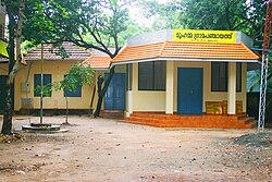
Muhamma Panchayaath Office
India Kerala location map.svg
Red pog.svg
Muhamma
Location in Kerala, India
Coordinates: 9°35′0″N76°21′0″E / 9.58333°N 76.35000°E / 9.58333; 76.35000
CountryFlag of India.svg  India
State Kerala
District Alappuzha
Government
  Type Panchayath
  BodyMuhamma grama panchayath
Population
 (2001)
  Total24,513
Languages
  Official Malayalam, English
Time zone UTC+5:30 (IST)
PIN
688525 [1]
Vehicle registration KL-04, KL-32 [2]
Lok Sabha constituency Alappuzha
Vidhan Sabha constituency [3] Cherthala

Muhamma is a census town in Cherthala Taluk in Alappuzha district in the Indian state of Kerala. [4] It is home to Cheerappanchira kalari, where Lord Ayyappa of Sabarimala had his training in the martial arts. Cheerappanchira is an Ezhava ancestral home in Muhamma. Muhamma was the village where the Communist Party of India (Marxist) leader P. Krishna Pillai died after sustaining a snake-bite. Pathiramanal island, one of the scenic spots in vembanad lake is a part of Muhamma Panchyath.Muhamma boat jetty offers ferry services to Kumarakom and Alappuzha. Pathiramnal island can be accessed by private owned boats and also by government operated water transport.

Contents

Demographics

As of 2001 India census, [5] Muhamma had a population of 24,518. Males constitute 48% of the population and females 52%. Muhamma has an average literacy rate of 85%, higher than the national average of 59.5%: male literacy is 88%, and female literacy is 83%. In Muhamma, 10% of the population is under 6 years of age.

YearMaleFemaleTotal PopulationChangeReligion (%)
HinduMuslimChristianSikhsBuddhistJainOther religions and persuasionsReligion not stated
2001 [6] 118301268824518-89.114.066.820.000.000.000.000.00
2011 [7] 1255313308258615.48%89.033.876.730.000.000.000.010.36

Geography

Muhamma is a small village in Alappuzha. Pathiramanal is a small island and tourist attraction in Muhamma. Kanjikkuzhi (S.L.Puram), Mannanchery and Thanneermukkom are neighbouring villages of Muhamma. The east side of the Muhamma is the Vembanad backwater, which borders Kottayam district. The other side of the backwater is Kumarakam. Muhamma-Kumarakam is the widest part of the Vembanad backwater. A distance of about 8 km can be travelled by boat (state water service is available) in 40 minutes.

Transport

Government ferry is available to Kumarakom, Cheepunkal and Maniaparampu

Ferry Services from Muhamma
DestinationDepartureRouteComments
Kumarakom5:45, 6:30, 7:15, 8:15, 9:00, 10:00,
11:00, 11:45, 13:00, 13:45, 14:45,
15:30, 16:30, 17:15, 18:15, 19:00
Across Vempanad Lake2 wheelers can be carried

Disclaimer: Depend on operating conditions

Maniaparambu11:00Cheepunkal[11:30]
Pathiramanal IslandSpecial(on-Demand)Tourists can book special boat
Contact Muhamma Station:9400050331

Related Research Articles

<span class="mw-page-title-main">Alappuzha district</span> District in Kerala, India

Alappuzha district, is one of the 14 districts in the Indian state of Kerala. It was formed as Alleppey district on 17 August 1957, the name of the district being changed to Alappuzha in 1990. Alappuzha is the smallest district of Kerala. Alleppey town, the district headquarters, was renamed Alappuzha in 2012, even though the anglicised name is still commonly used to describe the town as well as the district.

<span class="mw-page-title-main">Kokkamangalam</span> Village in Kerala, India

Kokkamangalam also known as Gokkamangalam is a village in Alappuzha district of Kerala state, south India. It is situated in between Cochin and Kumarakom and on the western shore of Vembanad Lake, 5 km east of the town of Cherthala, which has the nearest railway station.

<span class="mw-page-title-main">Kumarakom</span> Tourist village in Kerala, India

Kumarakom is a tourism destination located near the city of Kottayam, in Kerala, India, known for its backwater tourism. It is set in the backdrop of the Vembanad Lake, the largest lake in the state of Kerala. In January 2023, when Kerala was listed by The New York Times in their "52 places to go in 2023" list, Kumarakom got a special mention for its backwater tourism.

<span class="mw-page-title-main">Vaikom</span> Municipality in Kerala, India

Vaikom is a municipality in the Kottayam district of Kerala, India. It is located 33 km (20.5 mi) north of the district headquarters in Kottayam and about 152 km (94.4 mi) north of the state capital Thiruvananthapuram. As per the 2011 Indian census, Vaikom has a population of 23,234 people, and a population density of 2,661/km2 (6,890/sq mi).

<span class="mw-page-title-main">Kerala backwaters</span> Lagoon network in India

The Kerala backwaters are a network of brackish lagoons and canals lying parallel to the Arabian Sea of the Malabar coast of Kerala state in south-western India. It also includes interconnected lakes, rivers, and inlets, a labyrinthine system formed by more than 900 km (560 mi) of waterways, and sometimes compared to bayous. The network includes five large lakes linked by canals, both man made and natural, fed by 38 rivers, and extending virtually half the length of Kerala state. The backwaters were formed by the action of waves and shore currents creating low barrier islands across the mouths of the many rivers flowing down from the Western Ghats range. In the midst of this landscape there are a number of towns and cities, which serve as the starting and end points of backwater cruises. There are 34 backwaters in Kerala. Out of it, 27 are located either closer to Arabian Sea or parallel to the sea. The remaining 7 are inland navigation routes.

<span class="mw-page-title-main">Vembanad</span> Lake in Kerala, India

Vembanad is the longest lake in India, as well as the largest in the state of Kerala. The lake has an area of 230 square kilometers and a maximum length of 96.5 km.

<span class="mw-page-title-main">Pathiramanal</span> Island in Kerala, India

Pathiramanal is a small island in Muhamma panchayat of Alappuzha district located in Vembanad Lake. The name Pathiramanal means 'midnight sand'. It is home to many rare varieties of migratory birds from different parts of the world.

<span class="mw-page-title-main">Kayamkulam</span> Town in Kerala, India

Kayamkulam is a municipality in the Alappuzha district of Kerala, India. It is located 90 km (55.9 mi) south of the district headquarters in Alappuzha and about 98 km (60.9 mi) north of the state capital Thiruvananthapuram. As per the 2011 Indian census, Kayamkulam has a population of 68,634 people, and a population density of 3,149/km2 (8,160/sq mi).

<span class="mw-page-title-main">Alappuzha</span> City in Kerala, India

Alappuzha, also known as Alleppey, is a municipality in the Alappuzha district of Kerala, India. It is the district headquarters of the district, and is located about 130 km (80.8 mi) north of the state capital Thiruvananthapuram. As per the 2011 Indian census, Alappuzha has a population of 240,991 people, and a population density of 3,675/km2 (9,520/sq mi).

<span class="mw-page-title-main">Kainakary</span> Village in Kerala, India

Kainakary is a village in Kuttanad Taluk in Alappuzha District of the Indian state of Kerala.

<span class="mw-page-title-main">Kerala State Water Transport Department</span>

Kerala State Water Transport Department (SWTD) is a governmental department that regulates the inland navigation systems in the Indian state of Kerala and provides inland water transport facilities. It stands for catering to the traffic needs of the inhabitants of the waterlogged areas of the Districts of Alappuzha, Kottayam, Kollam, Ernakulam, Kannur and Kasaragod. The department is headed by the State Minister in charge of transportation.

Arookutty is a census town in Alappuzha district in the state of Kerala, India.

<span class="mw-page-title-main">Aroor</span> Village in Alappuzha district, Kerala, India

Aroor is a fishing village located within the northern border of the Alappuzha district in Cherthala taluk, Kerala, India. It lies on either sides of National Highway 66 and serves as a gateway between Kochi and Alappuzha. Aroor, surrounded by Vembanad, Kaithappuzha, and Kumbalangi backwaters, is known for its seafood export industry. The Aroor-Kumbalam Bridge is the second-longest bridge in Kerala.

Kokkothamangalam is a census town in Alappuzha district in the Indian state of Kerala.

Kodamthuruth is a village in Alappuzha district in the Indian state of Kerala. It is a panchayat, which comes under the Aroor Assembly constituency.

<span class="mw-page-title-main">Perumbalam</span> Village in Kerala, India

Perumbalam is an island village in Alappuzha district in the Indian state of Kerala. As of 2001 India census, Perumbalam had a population of 9678 with 4711 males and 4967 females. The village is situated upon an island in Vembanad lake. The island has a total land area of 6 square kilometers. It lies 600 meters to the west of the Ernakulam district of Kerala. Perumbalam will be connected with the mainland through the Perumbalam bridge, which is under construction as of December 2023.

<span class="mw-page-title-main">Thaikattussery</span> Village in Kerala, India

Thycattusserry is a village in the Cherthala taluk of the Alappuzha district in the Indian state of Kerala.

<span class="mw-page-title-main">National Waterway 3</span> National waterway of India

The West Coast Canal or National Waterway No 3 is a 205 km (127 mi) long inland navigational route located in Kerala, India, which runs from Kollam to Kottapuram. It was declared a National Waterway in 1993. In addition to the main stretch, Champakara and Udyogmandal canals are navigable and connect the industrial centers of Kochi to Kochi port Inland Waterways Authority of India (IWAI) under the Ministry of Shipping is coordinating the task for developing, monitoring and administering national waterways. It is the first National Waterway in the country with 24-hour navigation facilities along the entire stretch. It has been extended to Kozhikode by the National Waterways Act, 2016. The National Waterway 3 mainly passes through the previous Thiruvananthapuram–Shoranur canal.

<span class="mw-page-title-main">Kollam KSWTD Ferry Terminal</span>

Kollam KSWTD Boat Jetty or Kollam KSWTD Ferry Station is an transport hub in the city of Kollam in Kerala, India, one of 14 ferry stations owned by the Kerala State Water Transport Department.

Waterways have always been an important mode of transport in Kerala. The total length of navigable route in Kerala was 1,900 kilometres and the navigable rivers constitute about 54 per cent of the waterways. The 41 West-flowing rivers together with the backwaters are an integrated part of the inland navigation system in Kerala. In Kerala water transportation through these channels are mainly small distant passenger services, informal country boats, freight transportation to PSU's such as Fertilisers and Chemicals Travancore, Kochi etc.

References

  1. "Welcome to the Indiapost Website". Archived from the original on 20 May 2012. Retrieved 16 December 2008.
  2. http://www.keralamvd.gov.in/index.php?option=com_content&task=view&id=121&Itemid=5
  3. "CEO Kerala :: Alappuzha". Archived from the original on 13 March 2011. Retrieved 2 July 2011.
  4. "മുഹമ്മ ഗ്രാമപഞ്ചായത്ത് (Muhamma Grama Panchayat) » മുഹമ്മ". Archived from the original on 9 October 2011. Retrieved 11 July 2011.
  5. "Census of India 2001: Data from the 2001 Census, including cities, villages and towns (Provisional)". Census Commission of India. Archived from the original on 16 June 2004. Retrieved 1 November 2008.
  6. Census India 2001.
  7. Census India 2011.