
Palakkad is one of the 14 districts in the Indian state of Kerala. It was carved out of the southeastern region of the former Malabar District on 1 January 1957. It is located at the central region of Kerala and is the second largest district in the state after Idukki. The city of Palakkad is the district headquarters. Palakkad is bordered on the northwest by the Malappuram district, on the southwest by the Thrissur district, on the northeast by Nilgiris district, and on the east by Coimbatore district of Tamil Nadu. The district is nicknamed "The granary of Kerala". Palakkad is the gateway to Kerala due to the presence of the Palakkad Gap, in the Western Ghats. The 2,383 m high Anginda peak, which is situated in the border of Palakkad district, Nilgiris district, and Malappuram district, in Silent Valley National Park, is the highest point of elevation in Palakkad district. Palakkad city is about 347 kilometres (216 mi) northeast of the state capital, Thiruvananthapuram.

Nedumbassery is a census town within the Nedumbassery gram panchayat in the Aluva taluk of Ernakulam district, Kerala, India. Situated between Angamaly and Aluva, it is home to Cochin International Airport.
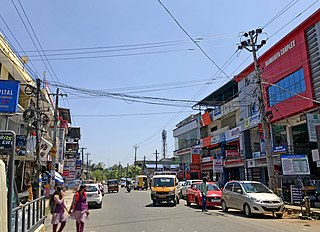
Alathur is a town, taluk and gram panchayat in Palakkad District, Kerala, India. It is the administrative headquarters of the Alathur Taluk and is situated about 24 km from the district headquarters Palakkad through National Highway 544.Gayathripuzha River, one of the tributary of Bharathapuzha, flows through Alathur. Alathur is one among the 20 Parliamentary Constituencies in Kerala. A Mini Civil Station is also located here which provides government related services.
The administrative divisions of India are subnational administrative units of India; they are composed of a nested hierarchy of administrative divisions.

Kalliasseri is a census town in Kannur district in the Indian state of Kerala. Kalliaseri Panchayat comprises two villages: Kalliasseri and Irinave.

Pappinisseri is a census town and a suburb of Kannur city in Kannur district in the Indian state of Kerala. Pappinissery have consistently won the Swaraj Trophy for best Grama Panchayat from 2017-2018 to 2021. Pappinisseri Panchayat also bagged the third position in the Swaraj Trophy during 2015-2016. Also, Pappinissery has been declared as the best Grama Panchayat in Kerala by Kerala government. Pappinisseri Panchayat comprises two villages, viz Pappinisseri and Aroli. Pappinisseri better known for visha chikitsa kendram

Paschim Medinipur district is one of the districts of the state of West Bengal, India. It was formed on 1 January 2002 after the partition of Midnapore into Paschim Medinipur and Purba Medinipur. On 4 April 2017, the Jhargram subdivision was upgraded to a district. GDP of West Midnapore district is 12 billion USD.

Mankada is a hillside village in the Malappuram district of Kerala state. It is located 15 km (9.3 mi) from Malappuram and is part of the Malappuram parliament constituency. The municipal town of Perinthalmanna is just 10 km (6.2 mi) away. Also, the municipal towns of Manjeri and Malappuram are just 15 km (9.3 mi) away. Mankada Kadannamanna Kovilakam was the seat of ruling family of the erstwhile Kingdom of Valluvanad.

Kumily, also spelt as Kumaly is a revenue village and Gram Panchayat in the Idukki district of the state of Kerala. It is a town in Cardamom Hills near Thekkady and Periyar Tiger Reserve. Kumily is a gateway town into Kerala from Tamil Nadu.
Pangode is an Indian village and a Grama Panchayat located in the Trivandrum district in the state of Kerala. The village is known for its participation in the Indian Independence Movement, through the Kallara-Pangode Struggle. It is situated in the foothills of Western Ghats.
Kerala is a state on the southwestern coast of India. It is known for its high literacy rate, low infant mortality rate, and long life expectancy.

Kuttampuzha is a village and gram panchayat in Ernakulam district in the Indian state of Kerala. Situated 71 km east of Kochi, Kuttampuzha panchayat is home to the 17.7% of total area of the Ernakulam District.
Elamadu is a village and Gram Panchayat in Kottarakkara tehsil in Kollam district in the state of Kerala, India.

Pallikkal is a T-shaped town, village and gram panchayat in Kondotty Taluk, Malappuram district in the state of Kerala, India.

Purathur is a sandy coastal village and a Grama Panchayat in Tirur Taluk, Malappuram district in the state of Kerala, India. Bharathappuzha river and Tirur River merges together in Purathur and join with the Arabian Sea at Padinjarekara Azhimukham, which is also the southernmost tip of Purathur Gram panchayat. Opposite to Padinjarekara Azhimukham is Ponnani port. The village is located at the southernmost tip of Tirur Taluk and is bordered by historically important Ponnani port in Ponnani Municipality of Ponnani taluk to south.
Ayiloor, also known as Ayilur, Aylur, or Ayalur, is a village in the Chittur Thaluk of Palakkad district, state of Kerala, India. Ayiloor is located about 30 kilometers away from Palakkad town and 48 kilometers from Thrissur town.
Koduvayur is a Census Town and Grama Panchayat in Palakkad district in the state of Kerala, India. Koduvayur Panchayat comprises Koduvayur-I and Koduvayur-II villages. As of the 2011 Census of India, Koduvayur-I village had a population of 20,703 spread over an area of 11.47 km2 (4.43 sq mi). It is one of the major commercial centre in the district and is located about 11 km from Palakkad through State Highway 27. It is part of the decentralized administrative system in India, aimed at ensuring local development and governance in rural areas. Koduvayur serves as an important centre for governance and public administration at the village.

Anthoor is a municipality, in Taliparamba taluk of the Kannur district in Kerala, India. The municipality had a population of 28,218 in the 2011 Indian census.
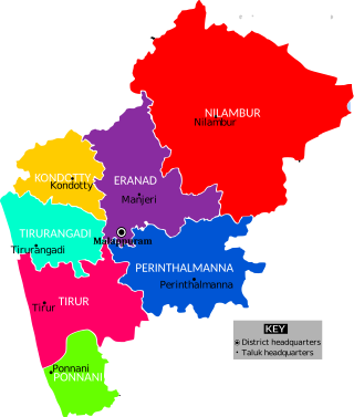
The Malappuram district has four types of administrative hierarchies:


