Parippally

Last updated

Parippally
Parippalli
Village
Entrance of Parippally ESIC Medical College.jpg
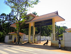
Govt Medical College KOLLAM
Parippally
Coordinates: 8°48′44″N76°45′32″E / 8.812361°N 76.758775°E / 8.812361; 76.758775
CountryFlag of India.svg  India
State Kerala
District Kollam
Government
  BodyKalluvathukkal Panchayath
Languages
  Official Malayalam, English
Time zone UTC+5:30 (IST)
Vehicle registration KL-02
Nearest city Kollam City (24 Km)
Assembly constituency Chathannoor
Lok Sabha constituency Kollam

Parippally is a village in kalluvathukkal panchayat Kollam, Kerala, India. Parippally is 22 kilometres (14 mi) South of Kollam City along NH66 and 44 kilometres (27 mi) North of Thiruvananthapuram along NH66. Kollam Govt. Medical College is situated in Parippally. Varkala sivagiri is nearest major Railway station 12 km(7.5 mi).

Contents

Transportation

As a major town on NH 66, on the route from Kollam to Thiruvananthapuram, Parippally is well connected to major places in Kerala. The nearest airport is Thiruvananthapuram International Airport, which is 45 kilometres (28 mi) away. Kollam Helipad (Asramam) is about 23 kilometres (14 mi) away from Parippally, and Varkala Helipad (Cliff) is about 13 kilometres (8.1 mi) away.

There are four major roads that connect Pallickal, Paravur, Kollam, and Thiruvananthapuram. Parippally is 13 kilometers from the Varkala Sivagiri, Varkala Beach, and Varkala Temple, and 16 kilometers from Jatayu Earth's Center Nature Park.

Administration

Parippally is the part of Kalluvathukkal Panchayath.

Institutions

1) UKF Engineering College is in Parippally.

2) Govt Medical College, Kollam is situated in Paripally.

Temples

One of the most famous temple in Parippally is Kodimoottil Sri Bhadrakaali Temple . Gajamela and Pongala which are associated with the temple festival are very famous. Thousands of devotees come to watch the Gajamela.

References