Ambalappuzha is a small town in the Alappuzha district of Kerala state, India. It is located 14 km (8.7 mi) south of Alappuzha which is the district headquarters.

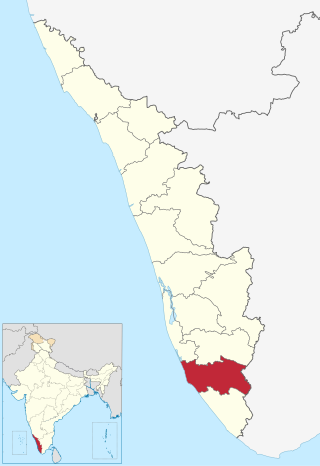
Kollam district, is one of 14 districts of the state of Kerala, India. The district has a cross-section of Kerala's natural attributes; it is endowed with a long coastline, a major Laccadive Sea seaport and an inland lake. The district has many water bodies. Kallada River is one among them, and land on the east bank of the river is East Kallada and that on the west bank is West Kallada.

Thrissur, anglicised as Trichur, is one of the 14 districts in the Indian state of Kerala. It is situated in the central region of the state. Spanning an area of about 3,032 km2 (1,171 sq mi), the district is home to over 9% of Kerala's population.
Pariyaram is a Grama Panchayat consisting of two villages viz. Pariyaram census town and Kuttiyeri village. Pariyaram is a suburb of Taliparamba on National Highway between Taliparamba and Payyanur in Kerala state of India. Mini villages of Thiruvattoor, Koran Peedika, Mukkunnu & Chithappile Poyil are parts of Pariyaram.
Karunagappally is a municipality in the Kollam district of Kerala, India. It is 24 km north of Kollam and 60 km (37 mi) south of Alappuzha. Karunagappally taluk consists of Alappad, Ochira, Adinad, Karunagappally, Thazhava, Pavumba, Thodiyoor, Kallalibhagom, Thevalakkara, Chavara, Neendakara, Clappana, Kulasekharapuram, Thekkumbhagam, Ayanivelikulangara, Panmana, Ponmana and Vadakumthala. The taluk is bound on the north by Kayamkulam, on the east by Kunnathur taluk, on the south by Kollam and on the west by the Arabian Sea. It is one of the fastest developing towns in Kerala and is part of Kollam metropolitan area.

Malumel is a locality in the Thodiyoor Panchayat of Kollam district, Kerala, India. The village belongs to Karunagappally Taluk.

Kuttampuzha is a village and gram panchayat in Ernakulam district in the Indian state of Kerala. Situated 71 km east of Kochi, Kuttampuzha panchayat is home to the 17.7% of total area of the Ernakulam District.

Cherukunnu is a census town in Kannur district in the Indian state of Kerala. Cherukunnu town is located on Valapattanam-Pappinisseri-Pazhayangadi main road, situated to the south of the Pazhayangadi in Kannur District in Kerala.
Kadannapalli is a census town in Kannur district of Kerala state, India.

Kurumathur is a census town in Taliparamba taluk of Kannur district in Kerala state, India. Kurumathur is located 8 km (5.0 mi) east of Taliparamba town in SH 36.

Karadka is a village, block panchayat and grama panchayat in Kasaragod district in the state of Kerala, India.
Karindalam is a village in Kasaragod district in the state of Kerala, India.
Edamulackal is a village and gram panchayat in Kollam district in the state of Kerala, India. Situated near the second fastest growing town of Kerala, Anchal. Ayoor is the main town thats located on the M C Road or state highway One, within the area limits of Edamulackal gram panchayat.
Mulavana is a village in Kollam district in the state of Kerala, India. The place is filled with almost all types of shops,which includes stationary,fancy,textile etc. The Mulavana fish market is regarded as the best market while comparing with the surrounding places.
Vazhoor is a town in Kottayam district in the state of Kerala, India.It is a village, panchayat and block with headquarters at Kodungoor on NH183. Basically an agrarian community inhabits this part, whose income depends on rubber cultivation

Purathur is a sandy coastal village and a Grama Panchayat in Tirur Taluk, Malappuram district in the state of Kerala, India. Bharathappuzha river and Tirur River merges together in Purathur and join with the Arabian Sea at Padinjarekara Azhimukham, which is also the southernmost tip of Purathur Gram panchayat. Opposite to Padinjarekara Azhimukham is Ponnani port. The village is located at the southernmost tip of Tirur Taluk and is bordered by historically important Ponnani port in Ponnani Municipality of Ponnani taluk to south.

The Malappuram Metropolitan Area or Malappuram Urban Agglomeration is an urban agglomeration centred around the city of Malappuram, Manjeri in Malappuram district, Kerala, India. It is the 25th largest urban agglomeration in India and the 4th largest in Kerala.
Kollam District has four types of administrative hierarchies:

Karunagappally State assembly constituency is one of the 140 state legislative assembly constituencies in Kerala state in southern India. It is also one of the 7 state legislative assembly constituencies included in the Alappuzha Lok Sabha constituency. As of the 2021 assembly elections, the current MLA is C. R. Mahesh of Indian National Congress.

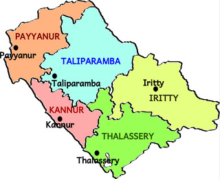
Taliparamba taluk is one of the five taluks in Kannur district in the state of Kerala, India. It borders Payyanur taluk in the north, Kannur taluk and Thalassery taluk in the south and Iritty taluk in the east. It is a revenue division for the ease of administrative purposes, and is headquartered in Taliparamba. Most government offices are in the Mini Civil Station in Taliparamba. Taliparamba taluk consists of Taliparamba Municipality, Anthoor Municipality, Sreekandapuram Municipality and 15 surrounding panchayats.


