Kannur is one of the 14 districts along the west coast in the state of Kerala, India. The city of Kannur is the district headquarters and gives the district its name. The old name, Cannanore, is the anglicized form of the Malayalam name "Kannur". Kannur district is bounded by Kasaragod District to the north, Kozhikode district to the south, Mahé district to the southwest and Wayanad District to the southeast. To the east, the district is bounded by the Western Ghats, which forms the border with the state of Karnataka. The Arabian Sea lies to the west. Paithalmala is the highest point in Kannur District (1,372m). Enclosed within the southern part of the district is the Mahé district of the Union Territory of Puducherry. The district was established in 1957.

Taliparamba is a Municipality in Taliparamba taluk of Kannur district, Kerala, India. The municipal town spreads over an area of 18.96 square kilometres (7.32 sq mi) and is inhabited by 44,247 number of people.

Iritty is a Municipality and a Taluk of Kannur district in Kerala State, India. The town is the main market place for the farmer communities in the surrounding regions. Iritty is known as The Coorg Valley in God's Own Country. Iritty is at a distance of 20 km (12 mi) from Kannur International Airport and one among five taluks in Kannur district. Iritty is one of the major towns lies between Coorg and Kannur international airport -Mattanur.
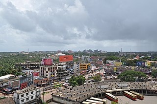
Kannur, formerly known in English as Cannanore, is a city and a municipal corporation in the state of Kerala, India. It is the administrative headquarters of the Kannur district and situated 274 kilometres (170 mi) north of the major port city and commercial hub Kochi and 137 kilometres (85 mi) south of the major port city and a commercial hub, Mangalore. During the period of British colonial rule in India, when Kannur was a part of the Malabar District, the city was known as Cannanore. Kannur is the sixth largest urban agglomeration in Kerala. As of 2011 census, Kannur Municipal Corporation, the local body which administers mainland area of city, had a population of 232,486.

Mattanur, also spelled Mattannur, is a town, municipality, and an aerotropolis in Kannur district, Kerala, India. Mattanur is about 27 km east of Kannur and Thalassery, two major towns of the district.
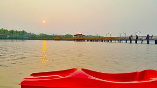
Azhikode is a coastal town and a suburb of Kannur city situated in Kannur district of Kerala, India. Azhikode town is divided into Azhikode North and Azhikode South. The northern end of the Azhikode North is called Azhikkal. The place is the birthplace of Sukumar Azhikode, an influential thinker and literary critic. It is about 7 km (4.3 mi) from Kannur city.
Kuthuparamba or Koothuparamba is a town and a municipality in the Kannur district, state of Kerala, India. It is about 24 km south-east of Kannur and 14 km east of Thalassery.
Pariyaram is a Grama Panchayat consisting of two villages viz. Pariyaram census town and Kuttiyeri village. Pariyaram is a suburb of Taliparamba on National Highway between Taliparamba and Payyanur in Kerala state of India. Mini villages of Thiruvattoor, Koran Peedika, Mukkunnu & Chithappile Poyil are parts of Pariyaram.

Matool is a village in Kannur district of Kerala State, India. Mattool is located 19 kilometres (12 mi) north of Kannur city. The Valapattanam River and Kuppam River meet the Arabian Sea at Mattool. Mattool can be reached from Kannur via Azheekal crossing the Mattool - Azheekal ferry. And via Madakkara-Matool Bridge From Irinavu Road.
Panoor is a Municipality in the district of Kannur in the state of Kerala, India. The town is the main market place for the farmer communities in the surrounding regions. Panoor is one of the main suburbs of the City of Thalassery. Panoor got municipal status when the Government of Kerala decided to upgrade Panoor Grama Panchayat and added with other Panchayats, as Panoor Municipality in 2015.

Pappinisseri is a census town and a suburb of Kannur city in Kannur district in the Indian state of Kerala. Pappinissery have consistently won the Swaraj Trophy for best Grama Panchayat from 2017-2018 to 2021. Pappinisseri Panchayat also bagged the third position in the Swaraj Trophy during 2015-2016. Also, Pappinissery has been declared as the best Grama Panchayat in Kerala by Kerala government. Pappinisseri Panchayat comprises two villages, viz Pappinisseri and Aroli. Pappinisseri better known for visha chikitsa kendram
Aruvanpalli Puthiyapurakkal Abdullakkutty (born 8 May 1967) is an Indian politician. He was elected as the National Vice President of the Bharatiya Janata Party on 26 September 2020. He has also served as the BJP Vice President of Kerala state. He is also a former member of Lok Sabha from Kannur and former MLA from Kannur constituency of Kerala state.

Karivellur is a census town and Gram Panchayat in Kannur district of Kerala state, India.

Kannur International Airport is an international airport serving the city of Kannur and the North Malabar region of Kerala, Kodagu district of Karnataka and Mahé district of Puducherry in India. It is located 28 km (17 mi) east of Kannur, and 24 km (15 mi) east of Thalassery, near the municipality of Mattannur in Thalassery taluka of Kannur district. It is owned and operated by Kannur International Airport Limited (KIAL), a public–private consortium. The airport opened for commercial operations on 9 December 2018.

Kannur railway station (station code: CAN) is an NSG–3 category Indian railway station in Palakkad railway division of Southern Railway zone. It is the largest railway station serving the City of Kannur in Kerala. It lies in the Shoranur–Mangalore section of the Southern Railway zone. It is the largest railway station in terms of area and number of tracks in North Malabar region. At ₹62 crore in financial year 2018–19, it is the fifth largest in terms of passenger revenues in Kerala, and second largest under Palakkad railway division. Almost all major trains connecting the other parts of Kerala, Tamil Nadu, Andhra Pradesh and North India halt here. Kannur and Kannur South are two different stations which serve Kannur city.

Tirur railway station is an NSG–3 category Indian railway station in Palakkad railway division of Southern Railway zone. It is the oldest railway station in Kerala. It is a major railway station serving the town of Tirur in Malappuram district of Kerala. It lies in the Shoranur–Mangalore section of the Southern Railway zone. The station has three platforms and four tracks. Though no trains originate from this station, trains halting at the station connect the town to prominent cities in India such as Thiruvananthapuram, Kochi, Kozhikode, Kollam, Thrissur, Kannur, Chennai, Mumbai, Bangalore, Coimbatore, Pondicherry, New Delhi, Mangalore, Chandigarh, Pune, Jaipur, Jammu Tawi, Okha, Ahmedabad, Kolkata and so on. This is an "A" class railway station which earns more than 30 crore per annum. It has now been upgraded to a Model Railway Station (Adarsh). The first railway line in Kerala was commissioned on 12 March 1861 from Beypore to Tirur. The proposed high-speed rail has a stop in Tirur. The new rear entrance and parking area are being set up on the eastern side of the station, opening to Tirur Market.

Anthoor is a municipality, in Taliparamba taluk of the Kannur district in Kerala, India. The municipality had a population of 28,218 in the 2011 Indian census.

The Kannur Municipal Corporation is the municipal corporation that administers the city of Kannur, Kerala. Established in 2015, the Corporation's first mayor was E. P. Latha. Kannur Corporation has two assembly constituencies – Kannur Assembly constituency and Azhikode Assembly constituency – both of which are part of the Kannur parliamentary constituency. The Corporation is headed by a Mayor and council, and manages 78.35 km2 of Kannur city, with a population of about 232,486 within that area. Kannur Municipal Corporation has been formed with functions to improve the infrastructure of town.
Sabarimala International Greenfield Airport, is a proposed greenfield international airport, which will serve the city of Kottayam and the pilgrimage site of Sabarimala (Pathanamthitta) in the state of Kerala, India. The airport will be built in between the towns of Erumeli South and Manimala. Pathanamthitta is the nearest major town to the proposed site. The proposed site is 53.9 km away from Sabarimala temple, 9.2 km away from Kanjirappally town and 9 km away from Ranni town. The site is located at about 40 km from the city of Kottayam. The site is spread over 2,570 acres (10.4 km2) of area. It is 136 km from the state capital, Thiruvananthapuram, and 113 km from Kochi. Once commissioned,this would be the fifth international airport in the state, thus, most international airports in the country.
