Malappuram, is one of the 14 districts in the Indian state of Kerala, with a coastline of 70 km (43 mi). The most populous district of Kerala, Malappuram is home to around 13% of the total population of the state. The district was formed on 16 June 1969, spanning an area of about 3,554 km2 (1,372 sq mi). It is the third-largest district of Kerala by area. It is bounded by Western Ghats and the Arabian Sea on either side. The district is divided into seven Taluks: Eranad, Kondotty, Nilambur, Perinthalmanna, Ponnani, Tirur, and Tirurangadi.

Ponnani is a municipality in Ponnani Taluk, Malappuram District, in the state of Kerala, India. It serves as the administrative center of the Taluk and Block Panchayat of the same name. It is situated at the estuary of Bharatappuzha, on its southern bank, and is bounded by the Arabian Sea on the west and a series of brackish lagoons in the south.

Tirur is a major municipal town in Tirur Taluk, Malappuram district, in the Indian state of Kerala, spread over an area of 16.55 square kilometres (6.39 sq mi).
Chamravattam is a village located in Malappuram district, Kerala, India. This village is on the shores of the Bharathapuzha.

The Kochi Metro is a rapid transit system serving the city of Kochi and the wider Kochi Metropolitan Region in Kerala, India. It was opened to the public within four years of starting construction, making it one of the fastest completed metro projects in India. The Kochi metro project is the first metro system in the country which connects rail, road and water transport facilities. It is also the first metro rail system in India to be operated using the Communication-Based Train Control (CBTC) signalling system, which requires minimum human intervention. The Kochi Water Metro is integrated with the Kochi Metro, which also serves as a feeder service to the suburbs along the rivers where transport accessibility is limited.

The Bharathappuzha, also known as the Nila or Ponnani River, is a river in the Indian states of Tamil Nadu and Kerala. With a length of 209 km, it is the second longest river that flows through Kerala after the Periyar. It flows through Palakkad Gap, which is also the largest opening in the Kerala portion of Western Ghats. The Nila has groomed the culture and life of South Malabar part of Kerala. It is also referred to as the "Peraar" in ancient scripts and documents. River Bharathapuzha is an interstate river and lifeline water source for a population residing in four administrative districts, namely Malappuram and Palakkad districts, and parts of Palakkad-Thrissur district border of Kerala and Coimbatore, and Tiruppur of Tamil Nadu. The fertile Thrissur-Ponnani Kole Wetlands lie on its bank.
P. Sreeramakrishnan is an Indian politician born on 14 November 1967 in Perinthalmanna. He is currently the resident Vice-Chairman of Norka-Roots. He became the Thirteenth Kerala Legislative Assembly member on 1 June 2011. He also served as the Speaker of Kerala Legislative Assembly from 2016 to 2021.
Thiruvananthapuram Metro is a proposed rapid transit system in the city of Thiruvananthapuram, the capital of the Indian state of Kerala. Thiruvananthapuram, the capital city of Kerala, is all set to have its metro system. Earlier, there was a plan to build a light metro system in the city. However, the plan was later changed to a conventional metro system.

Thrissur-Ponnani Kole Wetlands is a wetland lying in Thrissur and Malappuram districts in Kerala, India. It gives 40 per cent of the Kerala’s rice requirement and acts as a natural drainage system for Ponnani city, Thrissur city, Thrissur District, and Malappuram district. The Kole Wetlands is one of largest, highly productive and threatened wetlands in Kerala and lie on the Central Asian Flyway of migratory birds.

The Bogibeel Bridge is a combined road and rail bridge over the Brahmaputra River in the northeastern Indian state of Assam between Dhemaji district and Dibrugarh district, which was started in the year 2002 and took a total of 200 months(16 years and 8 months) to complete, Bogibeel river bridge is the longest rail-cum-road bridge in India, measuring 4.94 kilometres over the Brahmaputra river. As it is situated in an earthquake-prone area it is India's first bridge to have fully welded steel-concrete support beams that can withstand earthquakes of magnitudes up to 7 on the Richter scale. It is Asia's second longest rail-cum-road bridge and has a serviceable period of around 120 years.
Kerala Seaplane was a commercial seaplane service promoted by Kerala Tourism Infrastructure Limited in the Indian state of Kerala. It was launched on 2 June 2013 at Kollam with the inaugural flight being operated by Kairali Aviation. However, commercial operations could not start due to opposition from the local fishing community. The Kerala Government was keen on restarting regular operations of the project in 2014. The service was to be the first such service in mainland India, and the second in India after Jal Hans, which operates seaplanes in the Andaman and Nicobar Islands. Work on the Kerala seaplane project began at the end of July, 2012 and has been praised for being one of the fastest projects to be completed in Kerala.
The state of Bihar has a number of bridges, extending from few metres to a few kilometres. The history of long bridges goes back to the British Empire when the site for the Koilwar bridge was surveyed in 1851. Since then a number of small and large bridges have crept up. Some are even largest of their kind. Mahatma Gandhi Setu, joining Patna and Hajipur was India's longest river bridge from 1982 to 2017.
National Highway 66, commonly referred to as NH 66, is a mostly 4 lane 1640 km long busy National Highway that runs roughly north–south along the western coast of India, parallel to the Western Ghats. It connects Panvel, a city east of Mumbai (Bombay) to Cape Comorin (Kanyakumari) via Cochin (Kochi), passing through the states of Maharashtra, Goa, Karnataka, Kerala and Tamil Nadu.
Malappuram is one of the 14 districts in the South Indian state of Kerala. The district has a unique and eventful history starting from pre-historic times. During the early medieval period, the district was the home to two of the four major kingdoms that ruled Kerala. Perumpadappu was the original hometown of the Kingdom of Cochin, which is also known as Perumbadappu Swaroopam, and Nediyiruppu was the original hometown of the Zamorin of Calicut, which is also known as Nediyiruppu Swaroopam. Besides, the original headquarters of the Palakkad Rajas were also at Athavanad in the district.

Enathu Bridge is one of the main bridges in Main Central Road. It is situated in Enathu, Kerala and is connecting Kollam district with Pathanamthitta district. It is constructed in latest form in 2017 over Kallada River.

South Malabar refers to a geographical area of the southwestern coast of India covering some parts of the present-day Kerala state. South Malabar covers the regions included in present-day Kozhikode taluk of Kozhikode district, Wayanad district excluding Mananthavady taluk, the whole area of Malappuram district, Chavakkad taluk of Thrissur district, and Palakkad district, excluding parts of Chittur taluk. The Fort Kochi region of Kochi city also historically belongs to South Malabar. The term South Malabar refers to the region of the erstwhile Malabar District south to the river Korapuzha, and bears a high cultural similarity to both the Cochin and the North Malabar regions.

Palarivattom Flyover is considered to be one of the most notorious scams in the history of Kerala Public Works Department. The scam exposed the alleged nexus between politicians, bureaucracy and contractors.

Mangalam is a coastal village in Tirur Taluk, Malappuram district, Kerala, India. The village is located 9 kilometres (5.6 mi) south-west to the town of Tirur, 16 kilometres (9.9 mi) away from Ponnani, and 17 kilometres (11 mi) south to Tanur. Kootayi, known for its picturesque beach, is an important town in the jurisdiction of Mangalam Grama Panchayat.

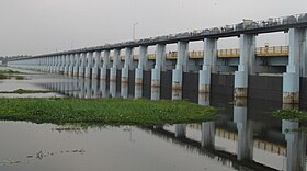
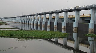
The Kuttippuram Bridge is a bridge that connects Kuttippuram with the Thavanur-Ponnani region in Malappuram district, Kerala, India. The Tirur and the Ponnani Taluks are separated by the river Bharathappuzha, which is also the second-longest river in Kerala. The bridge connects these two regions. It is a part of the National Highway 66 on the Kozhikode - Kochi route. It is one of the largest and oldest bridges built over the river Bharathappuzha, and plays a major role in connecting the Malabar region with the erstwhile Travancore-Cochin via road.

Events in the year 2012 in Kerala.