Beypore

Last updated

Beypore light house
city
India Kerala location map.svg
Red pog.svg
Beypore light house
Location in Kerala, India
India location map.svg
Red pog.svg
Beypore light house
Beypore light house (India)
Coordinates: 11°11′N75°49′E / 11.18°N 75.82°E / 11.18; 75.82
CountryFlag of India.svg  India
State Kerala
District Kozhikode
Area
[1]
  Total10 km2 (4 sq mi)
Elevation
1 m (3 ft)
Population
 (2011) [1]
  Total69,752
  Density7,000/km2 (18,000/sq mi)
Languages
  Official Malayalam, English
Time zone UTC+5:30 (IST)
Vehicle registration KL-85

Beypore or Beypur (formerly Beypoor) is an ancient port town and a locality town in Kozhikode district in the state of Kerala, India. It is located opposite to Chaliyam, the estuary where the river Chaliyar empties into Arabian Sea. Beypore is part of Kozhikode Municipal Corporation. The place was formerly known as Vaypura / Vadaparappanad and also as Beydary. Tippu Sultan, ruler of Mysore, named the town "Sultan Pattanam". There is a marina and a beach while Beypore port is one of the oldest ports in Kerala, which historically traded with the Middle East. Beypore is noted for building wooden ships, known as dhows or urus in the Malayalam language. These ships were usually bought by Arab merchants for trading and fishing but are now used as tourist ships. According to Captain Iwata, founder member of the Association of Sumerian ships in Japan, Sumerian ships might have been built in Beypore. There is evidence to prove that Beypore had direct trade links with Mesopotamia and was a prominent link on the maritime silk route. The first railway line of Kerala was laid in 1861 from Tirur to Beypore (Chaliyam) passing through Tanur, Parappanangadi, Vallikkunnu, and Kadalundi.

Contents

Beypore is located 10 km (6.2 mi) away from Kozhikode city.

Etymology

History

Names, routes and locations of the Periplus of the Erythraean Sea (1st century CE) Periplous of the Erythraean Sea.svg
Names, routes and locations of the Periplus of the Erythraean Sea (1st century CE)

The ancient trading port of Tyndis is often identified with Kadalundi-Chaliyam-Beypore region. Tyndis was a major center of trade, next only to Muziris, between the Cheras and the Roman Empire. [2] Pliny the Elder (1st century CE) states that the port of Tyndis was located at the northwestern border of Keprobotos (Chera dynasty). [3] The North Malabar region, which lies north of the port at Tyndis , was ruled by the kingdom of Ezhimala during Sangam period. [4] According to the Periplus of the Erythraean Sea , a region known as Limyrike began at Naura and Tyndis . However the Ptolemy mentions only Tyndis as the Limyrike's starting point. The region probably ended at Kanyakumari; it thus roughly corresponds to the present-day Malabar Coast. The value of Rome's annual trade with the region was estimated at around 50,000,000 sesterces. [5] Pliny the Elder mentioned that Limyrike was prone by pirates. [6] The Cosmas Indicopleustes mentioned that the Limyrike was a source of peppers. [7] [8]

According to the Legend of Cheraman Perumals, the first Indian mosque was built in 624 AD at Kodungallur with the mandate of the last the ruler (the Cheraman Perumal) of Chera dynasty, who converted to Islam during the lifetime of Muhammad (c. 570–632). [9] [10] [11] [12] According to Qissat Shakarwati Farmad , the Masjids at Kodungallur, Kollam, Madayi, Barkur, Mangalore, Kasaragod, Kannur, Dharmadam, Panthalayini, and Chaliyam (just opposite to Beypore), were built during the era of Malik Dinar, and they are among the oldest Masjids in the Indian subcontinent. [13] It is believed that Malik Dinar died at Thalangara in Kasaragod town. [14]

In medieval period, Beypore was ruled by four Kovilakams - Karippa Puthiyakovilakam, Manayat Kovilakam, Nediyaal Kovilakam and Panagad Kovilakam. As the Gazetteers explain, the Beypore amsam itself had four Kovilakams called - Manayatt kovilakam, Nediyal kovilakom, Puthiya kovilakom and the Panangat kovilakom belonging to the family of the Beypore branch of the Parappanad family. Parappanad royal family is a cousin dynasty of the more famous Travancore royal family. Marthanda Varma, the founder of Travancore, belongs to Parappanad royal family. They also had branches at Parappanangadi, Vallikkunnu and Beypore. [15] So we have North and South Parappanad factions to start with, branching off the Parappur lordship. The North faction was further split into Beypore, Cheruvannor and Panniyankara Kovilakoms. Considering that Ravi Varma and his brother mentioned Beypore and the specific Manayyat location, let us for a moment assume Raja Ravi Varma hailed from the forerunners of the present Manayyat kovilakom.

Raja Raja Varma in his diary states - Near this ‘Beypore’ Kovilakam or house is a temple of Vettakaruman or the Hunter God which it is said and acknowledged by its present owners, the Manayam Rajahs, once belonged to us of the Tattari Kovilakam house, by which our family was known. Based on all the above, I would assume that the original Parappanad rajas named their home the Tattari Kovilakom. It is from this home, which incidentally is further linked to the Kolathunad Rajas (Kolathiris) that various rulers (such as Marthanda Varma) and consorts as well as adoptees to the Travancore kingdom originated. Of course as we see, the ruling king usually reserved the right on the name raja and took affront to another cousin using the title while a raja was in power and complained, but then again, Ravi Varma in reality had some self-projection in mind, as we note. Now let us study the relations between the Parappanad Kovilakoms and the Travancore royal family to see where and how Ravi Varma fits in.

It is believed that the Beypore Siva Temple protects the whole kingdom. Beypore was visited first by Romans and afterwards by Chinese, Syrians, Arabs and in recent centuries by Europeans for trade. Beypore has long history of being a centre for shipbuilding since the first century AD, and it was further expanded under the East India Company during the early nineteenth century. The Indian Ocean trade started from ancient times and strengthened during the medieval times. While in the old days Malabar directly traded with the Greeks and Romans, it concentrated on exchanges with the Middle Eastern ports in the medieval times. This exchange of goods resulted also in transfer of people from their abodes. While it is mentioned that Malabari's were found along African ports and even Egypt's, it was mostly Arabs who migrated to the Malabar coasts, mainly to administer, control and conduct the trade with their brethren in Yemen, Basra and Egyptian ports. Beypore was virtually free port with only an export import duty imposed by the ruling Zamorins. The intermediaries between the Arabs and the Nairs were the Moplah's (themselves a community started by the intermingling Arab men and local women from ancient times). Also the south east Malay ports sent ships to Malabar for the cloth from Kerala, until British cloth took its place later in the 19th century. It was also a stop over for Hajj pilgrims from south east Asia. The Arab settlers in Malabar even had African slaves during that period. The internationally well known Tasara Creative Weaving Centre which attracts textile artists and designers from all over the world is situated in North Beypore which is just one Km away from the Boat building yard. Beypore was known as Beydhaalhee in neighboring Maldives. Maldivian national hero Muhammad Thakurufan learnt martial art and did his religious studies in Beypore.

Beypore Port

Beypore is world-famous for the ancient design boats called Urus Uru.jpg
Beypore is world-famous for the ancient design boats called Urus

Beypore port is a sub-port of Kozhikode port and is approximately 10 km (6.2 mi) south of Kozhikode. The land for the port was acquired from Beypore Karippa Puthiyakovilakam in 1963 and 1964. It is an estuarine port, where Beypore river discharges into the Arabian Sea. Beypore is 180 km (110 mi) North of Cochin and 391 km (243 mi) away from Trivandrum. Beypore port is the second biggest port in Kerala after Cochin and currently handles about 100,000 tonnes of cargo and 7500 passengers per annum. The nearest ports are Kochi and Mangalore. Now the port has a depth of about 5 metres (16 ft) alongside wharf and approach channel and it is proposed to be developed in stages and utilities like storage shed, cranes and tugs are already installed. Beypore port is one of the oldest ports in Kerala from where trading was done to the Middle East.

Uru Building

Beypore has a reputation for boat building Sd11-boom.JPG
Beypore has a reputation for boat building

The Uru (boat), or "Fat Boat", is a generic name for large Dhow-type wooden ships made in Beypore.[ citation needed ] This type of boat has been used by the Arabs since ancient times as trading vessels, and even now, urus are being manufactured and exported to Arab nations from Beypore. [16] These boats used to be built of several types of wood, the main one being teak. The teak was taken from Nilambur forests in earlier times, but now imported Malaysian teak is used. [17]

Geography

Beypore is located at 11°11′N75°49′E / 11.18°N 75.82°E / 11.18; 75.82 . [18] It has an average elevation of one metre (3 ft 3 in).

Travel information

By road : Beypore is well connected by road and is just 11 km (6.8 mi) from Kozhikode.

By air : Calicut airport, is at Karipur and is 23 km (14 mi) from Kozhikode city centre

By rail : Kozhikode station 10 km (6.2 mi) apart and Feroke 4 km (2.5 mi) apart

Demographics

As of 2001 India census, "Census of India 2001: Data from the 2001 Census, including cities, villages and towns (Provisional)". Census Commission of India. Archived from the original on 16 June 2004. Retrieved 1 November 2008. Beypore had a population of 66,883. Males constitute 49% of the population and females 51%. Beypore has an average literacy rate of 81%, higher than the national average of 59.5%; with 50% of the males and 50% of females literate. 13% of the population is under 6 years of age.

Cheruvannur festival Cheruvannur 06146.JPG
Cheruvannur festival

Notable residents

Places of attraction

Notable Government Offices

Indian Coast Guard has established its only third station in Kerala at Beypore, namely Coast Guard Station Beypore. It was commissioned on 25 May 2006.

See also

Related Research Articles

<span class="mw-page-title-main">Malappuram district</span> District in Kerala, India

Malappuram, is one of the 14 districts in the Indian state of Kerala, with a coastline of 70 km (43 mi). The most populous district of Kerala, Malappuram is home to around 13% of the total population of the state. The district was formed on 16 June 1969, spanning an area of about 3,554 km2 (1,372 sq mi). It is the third-largest district of Kerala by area. It is bounded by Western Ghats and the Arabian Sea on either side. The district is divided into seven Taluks: Eranad, Kondotty, Nilambur, Perinthalmanna, Ponnani, Tirur, and Tirurangadi.

<span class="mw-page-title-main">Nilambur</span> Place in Kerala, India

Nilambur is a major town, a municipality and a Taluk in the Malappuram district of the Indian state of Kerala. It is located close to the Nilgiris range of the Western Ghats on the banks of the Chaliyar River. This place is also known as 'Teak Town' because of the abundance of Nilambur teaks in this area; Which is a variety of a large, deciduous tree that occurs in mixed hardwood forests. Unlike many Municipalities of India; Nilambur is covered with large amounts of vegetation making it close to nature and hence make it very scenic and inspiring.

<span class="mw-page-title-main">Malabar District</span> Administrative district of Bombay and later Madras from 1792 to 1956

Malabar District, also known as Malayalam District, was an administrative district on the southwestern Malabar Coast of Bombay Presidency (1792–1800), Madras Presidency (1800–1937), Madras Province (1937–1950) and finally, Madras State (1950–1956) in India. It was the most populous and the third-largest district in the erstwhile Madras State. The historic town of Calicut was the admisnitrative headquarters of this district.

<span class="mw-page-title-main">Feroke</span> Municipality in Kerala, India

Feroke is a Municipality and a part of Kozhikode metropolitan area under Kozhikode Development Authority (K.D.A) in the Kozhikode district of the Indian state of Kerala.

<span class="mw-page-title-main">Tanur, Malappuram</span> Municipality in Kerala, India

Tanur is a coastal town, a municipality, and a block located in Tirur Taluk, Malappuram district, Kerala, India. It is located on the Malabar Coast, 9 kilometres (5.6 mi) north of Tirur and 9 kilometres south of Parappanangadi. It is the 17th-most populated municipality in the state, the fourth-most populated municipality in the district, and the second-most densely populated municipality in Malappuram district, having about 3,568 residents per square kilometre as of the year 2011.

<span class="mw-page-title-main">Ramanattukara</span> Municipality/Suburb in Kozhikode, Kerala, India

Ramanattukara is a municipality census town in Kozhikode district in the Indian state of Kerala. This town was formerly called Kadungan Chira village. Ramanattukara is located 15 km away from Kozhikode city.

<span class="mw-page-title-main">Kadalundi River</span> River in Kerala, India

Kadalundi River (Kadalundipuzha) is one of the four major rivers flowing through Malappuram district in the Indian state of Kerala. The other three are the Chaliyar, the Bharathappuzha and the Tirur River. This rain-fed river is 130 kilometres (81 mi) long and is one of the most important rivers in the district. Kadalundi River is also the sixth longest River in Kerala. Kadalundi River passes through [Karuvarakundu, Tuvvur [Melattur, Kerala|Melattur]], Pandikkad, Manjeri, Malappuram, Panakkad, Parappur, Vengara, Tirurangadi, Parappanangadi, Vallikkunnu, and empties itself into Arabian sea at Kadalundi Nagaram in Vallikkunnu on the northwestern border of the district. It is formed by the confluence of the Olippuzha River and the Veliyar River. The Kadalundi originates from the Western Ghats at the western border of the Silent Valley and flows through the district of Malappuram. It has two main tributaries namely Olipuzha and Veliyar. Olipuzha and Veliyar merges together to become Kadalundi River near Melattur. Kadalundi River traverses through the historical regions of Eranad and Valluvanad. The Kadalundi River drains an area of 1274 km² and has a length of 120 km. The ancient port of Tyndis, which was the second-largest trading port of Chera dynasty, only after to Muziris, is identified with the mouth of this river at Vallikunnu. The Kadalundi Bird Sanctuary spreads over a cluster of islands where the Kadalundipuzha River flows into the Arabian Sea. There are over a hundred species of native birds and around 60 species of migratory birds in large numbers annually.

<span class="mw-page-title-main">Parappanangadi</span> Municipality in Kerala, India

Parappanangadi is a major town and a municipality in Tirurangadi taluk of Malappuram district, Kerala, India. It is a coastal town located close to the Arabian sea.

<span class="mw-page-title-main">Vallikkunnu</span> Village in Kerala, India

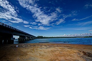
Vallikkunnu is a village in Tirurangadi Taluk of Malappuram district in the state of Kerala, India with an area of 25 km2. It is located 5 km north of Parappanangadi town and comes under the jurisdiction of Parappanangadi Police Station and Parappanangadi Judicial First Class Magistrate Court. Its latitude and longitude are 11'07" N and 7'51"E respectively. Vallikkunnu was awarded the best panchayath of Kerala in 1997. Vallikunnu is situated on Tirur-Kadalundi Road. Vallikkunnu is also a part of the Oldest Railway Line of Kerala laid in 1861 from Tirur to Chaliyam via Tanur, Parappanangadi, Vallikkunnu, and Kadalundi.

<span class="mw-page-title-main">Kadalundi</span> Village in Kerala, India

Kadalundi is a village in Kozhikode district, Kerala, India. It is a coastal village close to the Arabian Sea. Kadalundi is famous for its bird sanctuary, which is home to various migratory birds during certain seasons and has been recently declared as a bio-reserve. The Kadalundi–Vallikkunnu Community Reserve is the first community reserve in Kerala. The Kadalundi River and the Chaliyar river, two of the longest rivers of Kerala, merges with the Arabian Sea at Kadalundi. The first railway line in Kerala was laid in 1861 from Tirur to Chaliyam through Tanur, Parappanangadi, Vallikkunnu, and Kadalundi.

<span class="mw-page-title-main">Eranad</span> Erstwhile Province in Kerala, India

Eranad also known as Ernad refers to the erstwhile province in the midland area of Malabar, consisting of Malappuram and nearby regions such as Anakkayam, Manjeri, Kondotty, Nilambur, etc. Currently Eranad Taluk is a Taluk in Malappuram district. Eranad was ruled by a Samanthan Nair clan known as Eradis, similar to the Vellodis of neighbouring Valluvanad and Nedungadis of Nedunganad. The rulers of Eranad were known by the title Eralppad/Eradi. They also used the title Thirumulpad.

<span class="mw-page-title-main">Tyndis</span> Ancient Indian seaport/harbor-town mentioned in the Graeco-Roman writings

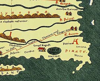
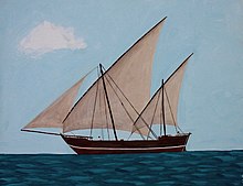
Tyndis was an ancient Indian seaport/harbor-town mentioned in the Graeco-Roman writings. According to the Periplus of the Erythraean Sea, Tyndis was located north of port Muziris in the country of the Cerobothra.

<span class="mw-page-title-main">Malabar Coast</span> Southwestern coast of the India

The Malabar Coast is the southwestern region of the Indian subcontinent. It generally refers to the western coastline of India stretching from Konkan to Kanyakumari. Geographically, it comprises one of the wettest regions of the subcontinent, which includes the Kanara region of Karnataka and all of Kerala.

Parappanad was a former feudal city-state in Malabar, India. The headquarters of Parappanad Royal family was at the town Parappanangadi in present-day Malappuram district. In 1425, the country divided into Northern Parappanad and Southern Parappanad. Southern Parappanad included parts of Tirurangadi Taluk and the town Parappanangadi. Northern Parappanad included Panniyankara, Beypore, and Cheruvannur of Kozhikkode Taluk. Parappanad royal family is a cousin dynasty of the Travancore royal family.

<span class="mw-page-title-main">Calicut (kingdom)</span> Historical kingdom in the region of Kerala

The Kingdom of Kozhikode, also known as Calicut, was the kingdom of the Zamorin of Calicut, in the present-day Indian state of Kerala. Present-day Kozhikode is the second largest city in Kerala, as well as the headquarters of Kozhikode district.

<span class="mw-page-title-main">Chaliyam</span> Village in Kerala, India

Chaliyam is a village situated at the estuary of Chaliyar in Kozhikode district of Kerala, India. Chaliyam forms an island, bounded by the Chaliyar in the north, and River Kadalundi in south, and the Conolly Canal in the east. It is located just opposite to Beypore port. Chaliyam was the former terminus of the South-West Line of the Madras Railway. Chaliyam is also famous for the Guinness World Records holder Muhammed Adil, a P.M who covered around seven km in the Chaliyar River with his hand and legs tied with ropes.

Malappuram is one of the 14 districts in the South Indian state of Kerala. The district has a unique and eventful history starting from pre-historic times. During the early medieval period, the district was the home to two of the four major kingdoms that ruled Kerala. Perumpadappu was the original hometown of the Kingdom of Cochin, which is also known as Perumbadappu Swaroopam, and Nediyiruppu was the original hometown of the Zamorin of Calicut, which is also known as Nediyiruppu Swaroopam. Besides, the original headquarters of the Palakkad Rajas were also at Athavanad in the district.

<span class="mw-page-title-main">Kozhikode Municipal Corporation</span> Local civic body in Kozhikode, Kerala, India

Kozhikode Corporation is the municipal corporation that administers the city of Kozhikode (Calicut), Kerala. Established in 1962, it is in the Kozhikode parliamentary constituency. The first mayor was H. Manjunatha Rao. Its four assembly constituencies are Kozhikode North, Kozhikode South, Beypore and Elathur. The Corporation is headed by a Mayor and council, and manages 118.58 km2 of the city of Kozhikode, with a population of about 609,224 within that area. Kozhikode Municipal Corporation has been formed with functions to improve the infrastructure of town.

<span class="mw-page-title-main">South Malabar</span> Geographical / Historical Area in Kerala, India

South Malabar refers to a geographical area of the southwestern coast of India covering some parts of the present-day Kerala state. South Malabar covers the regions included in present-day Kozhikode taluk of Kozhikode district, the whole area of Malappuram district, Chavakkad taluk of Thrissur district, and Palakkad district, excluding parts of Chittur taluk. The Fort Kochi region of Kochi city also historically belongs to South Malabar. The term South Malabar refers to the region of the erstwhile Malabar District south to the river Korapuzha, and bears a high cultural similarity to both the Cochin and the North Malabar regions.

References

  1. 1 2 "Master Plan | Kozhikode Municipal Corporation".
  2. Coastal Histories: Society and Ecology in Pre-modern India, Yogesh Sharma, Primus Books 2010
  3. Gurukkal, R., & Whittaker, D. (2001). In search of Muziris. Journal of Roman Archaeology,14, 334-350.
  4. A. Shreedhara Menon, A Survey of Kerala History
  5. According to Pliny the Elder, goods from India were sold in the Empire at 100 times their original purchase price. See
  6. Bostock, John (1855). "26 (Voyages to India)". Pliny the Elder, The Natural History. London: Taylor and Francis.
  7. Indicopleustes, Cosmas (1897). Christian Topography. 11. United Kingdom: The Tertullian Project. pp. 358–373.
  8. Das, Santosh Kumar (2006). The Economic History of Ancient India. Genesis Publishing Pvt Ltd. p. 301.
  9. Jonathan Goldstein (1999). The Jews of China. M. E. Sharpe. p. 123. ISBN   9780765601049.
  10. Edward Simpson; Kai Kresse (2008). Struggling with History: Islam and Cosmopolitanism in the Western Indian Ocean. Columbia University Press. p. 333. ISBN   978-0-231-70024-5 . Retrieved 24 July 2012.
  11. Uri M. Kupferschmidt (1987). The Supreme Muslim Council: Islam Under the British Mandate for Palestine. Brill. pp. 458–459. ISBN   978-90-04-07929-8 . Retrieved 25 July 2012.
  12. Husain Raṇṭattāṇi (2007). Mappila Muslims: A Study on Society and Anti Colonial Struggles. Other Books. pp. 179–. ISBN   978-81-903887-8-8 . Retrieved 25 July 2012.
  13. Prange, Sebastian R. Monsoon Islam: Trade and Faith on the Medieval Malabar Coast. Cambridge University Press, 2018. 98.
  14. Pg 58, Cultural heritage of Kerala: an introduction, A. Sreedhara Menon, East-West Publications, 1978
  15. K. V. Krishna Iyer (1938), Zamorins of Calicut: From the earliest times to AD 1806, Norman Printing Bureau, Kozhikode
  16. "Archived copy". Archived from the original on 3 February 2018. Retrieved 15 October 2019.{{cite web}}: CS1 maint: archived copy as title (link)
  17. https://www.facebook.com/238044912896496/videos/1454648004569508 [ user-generated source ]
  18. Falling Rain Genomics, Inc - Beypore
  19. "Basheer's Janmadhinam". Archived from the original on 18 December 2011. Retrieved 27 December 2011.