Neyyattinkara, is a significant municipal town and a prominent center for both industry and commerce, positioned at the southernmost tip of the Thiruvananthapuram metropolitan area in Trivandrum, the capital of Kerala State. It also serves as the administrative headquarters of Neyyattinkara Taluk.Nestled along the banks of the Neyyar River, one of the district's principal rivers, the town derives its name from its location, with 'Neyyatinkara' in Malayalam translating to 'the shore of the river Neyyar.' Neyyattinkara ranks as the second most densely populated municipality in the district, following Varkala. Notably, the Vizhinjam International Seaport Thiruvananthapuram is situated within Neyyattinkara Taluk."

Balussery is a town located about 25 km northeast of Kozhikode city and lies on State Highway 34. It is one of the 12 block Panchayats in Kozhikode district. Balussery is the Northeast side entry of Calicut city.

Edappally is a ward of Kochi, Kerala. The name is also used to refer to adjacent wards of Kalamassery and Thrikkakkara municipalities. Edappally is a major commercial centre as well as a prominent residential region. Edappally junction is one of the busiest junctions in the city.

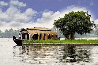
Alappuzha, also known as Alleppey, is the administrative headquarters of Alappuzha district in the state of Kerala, India. The backwaters of Alappuzha are one of the most popular tourist attractions in India which attracts millions of domestic and international tourists.

Palakkad, also known as Palghat, historically known as Palakkattussery, is a city and municipality in the Indian state of Kerala. It is the administrative headquarters of Palakkad District. Palakkad is the most densely populated municipality and the fourth-most densely populated city in the state. It was established before Indian independence under British rule and known by the name Palghat. Palakkad is famous for the ancient Palakkad Fort, which is in the heart of the city and was captured and rebuilt by Hyder Ali in 1766 which later fell into the hands of Zamorin in 1784. The city is about 347 kilometres (216 mi) northeast of the state capital, Thiruvananthapuram.
Edacheri is a small panchayath in the district of Kozhikode in the South Indian state of Kerala.

Nayarambalam is a suburb of Cochin city and coastal village on Vypin island in Ernakulam district in the state of Kerala, India.
Ezhikkara is a panchayat in Paravur Taluk of Ernakulam District, Kerala. The North Paravur, Chathanad road (9 km) passes through this village. Ezhikkara is situated close to Ernakulam. Ezhikkara is famous for its pokkali fields and prawn farms.

Idimuzhikkal or Chelembra is a town in Malappuram district, Kerala, India. Chelembra is the Panchayath and Idimuzhikal is the capital of this Panchayath. Chelembra grama panchayat in the district.

Edakkara is a town located in Malappuram district of the Indian state of Kerala. It is an emerging commercial hub, and one of the busiest towns in Nilambur Taluk.
Meppayur is a town in Kozhikode district of Kerala state, South India.
Vettikkavala is a village located in the Kollam district in the state of Kerala, India. One point of interest within the village is a Shiva-Vishnu temple which hosts a special deity called Vathukkal Njali Kunju. An annual celebration of Pongala is held at the temple. The village is also well known for temple arts and a palace constructed by Sree Moolam Thirunal.
Chelannur is a village in Kozhikode district in the state of Kerala, India.The village is currently ruled by the United Democratic Front (UDF)
Ulliyeri is a village in Kozhikode district in the state of Kerala, India. Ulliyeri is between Koyilandy and Balussery and also between Kuttiyadi and Kozhikode.
Vellarada is a border village situated in Thiruvananthapuram district in the state of Kerala, India. It is 42 km from Thiruvananthapuram. It is the southernmost part of Kerala state, sharing its border with Tamil Nadu. Vellarada is said to be the threshold to the high-range areas of the eastern part of Thiruvananthapuram district. The southernmost point of Western Ghats in Kerala is near Vellarada.
Manacaud is a locality in Thiruvananthapuram, the capital of Kerala, India. This place is situated between Kamaleswaram and Attakulangara on East Fort - Kovalam - Vizhinjam Road. The United Arab Emirates embassy is also situated in Manacaud.

Thamarassery, formerly known as Thazhmalachery, is one of the taluks and a major hill town in the Kozhikode district of Kerala, India, 30 km north-east of Kozhikode (Calicut) city and 29 km east of Koyilandy. The town lies on National highway 766.
Vanchiyoor is a locality in downtown Thiruvananthapuram city, the capital of the India state of Kerala. Vanchiyoor occupies an important place in the history of Travancore. It was the district headquarters and most important offices were situated here. There are a lot of heritage monuments in the area. Major administrative, commercial, government and judicial establishments are still located in Vanchiyoor. It is part of Vanchiyoor Village, which holds the prominent administrative headquarters and landmarks of Kerala. Proximity with major educational institutions, offices and shopping centres coupled with easy road connectivity with all parts of the city make it a favoured residential locale in Thiruvananthapuram. Vanchiyoor is 2 kilometres (1.2 mi) from Statue Junction, about 3 kilometres (1.9 mi) from Palayam and 2 kilometres (1.2 mi) from the central railway and bus stations. Trivandrum International Airport lies 6 kilometres (3.7 mi) to the southwest of Vanchiyoor.

Muttom is a rural area in Idukki district in the Indian state of Kerala. This place is 66 km away from Cochin. Geographically this place is part of Midland or Idanad region of Kerala.

Ayathil is a neighbourhood in Vadakkevila zone of Kollam city, Kerala, India. It is the 36th ward in Kollam Municipal Corporation. It is one of the cashew processing hubs in Kollam city. Kerala State Cashew Development Corporation Limited has a factory there. Kollam Bypass passes through Ayathil.


