Importance
Eranchipalam was famous for automobile workshops, spare parts shops and small scale industrial units. The place was the main source of automobile secondary markets of the region. KSRTC regional works shop of Kozhikode is situated in Eranchipalam. Erachipalam was not a primary place of residence in the Calicut city, it was an industrial area mainly for the automobile sector. However, since the arrival of new generation vehicles like Maruti, Tata, Hundai the customers moved to authorized/ dealer workshop and business of small workshops diminished. Still, the place is the major source of automobiles industrial needs of the city.
Now Erachipalam is a thriving residential area of the city. Mega residential projects like Erachipalam Housing colony, Hilite, Alhind Towers makes Eranchipalam a major residential hub of Calicut city.
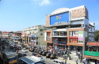
Eranhipalam was farmland before 1990s. Paul Nagar is one of the oldest missionary establishment in the area. Towards the start of 1995, Calicut development authority started backfilling of water filled fields and constructed low-cost housing projects for the low-income category under a government scheme. The plots were issued to nominated eligible individuals to establish a colony in city limit. During the period 1998–2005 the area developed drastically in terms of infrastructure like Roads, electricity, water supply, co-operative hospital, ESI and slowly the city developed towards Eranhipalam area. City bus services extended to the locality. Currently, this is the hot spot of Calicut city with all governmental and commercial establishments including offices, college, hospital, clubs, hotels, restaurants, supermarts, bike and car showrooms and so on... which turns it as a city hub.
The area is located geographically in a hot spot linking main town and tourism spot dream city swapna nagari bio park. The area is still in the beginning stage of tourism development and has immense potential ahead.

Kozhikode, also known in English as Calicut, is a city along the Malabar Coast in the state of Kerala in India. Known as the City of Spices, Kozhikode is listed among the UNESCO's Cities of Literature.
Sultan Bathery is a town and municipality in the Wayanad district of Kerala, India, near its borders with Tamil Nadu and Karnataka. Once known as a strategic location in the Malabar region, Sultan Bathery is the headquarters of the Sultan Bathery taluk.
Vatakara,, , French: Bargaret, is a Municipality, Taluk and a major town in the Kozhikode district of Kerala state, India. The municipality of Vatakara covers an area of 23.33 km2 (9.01 sq mi) and is bordered by Mahé to the north and Payyoli to the south. It is the headquarters of Vatakara taluk, which consists of 22 panchayats. During the reign of the Kolathiris and Zamorins, Vatakara was known as Kadathanadu. During the British Raj, it was part of the North Malabar region of Malabar District in the state of Madras. The historic Lokanarkavu temple, made famous by the Vadakkan Pattukal, is situated in Vatakara. A new tardigrade species collected from Vadakara coast has been named after Kerala State; Stygarctus keralensis.

Balussery is a town located about 25 km northeast of Kozhikode city and lies on State Highway 34. It is one of the 12 block Panchayats in Kozhikode district. Balussery is the Northeast side entry of Calicut city.

Kozhikode, or Calicut district, is one of the 14 districts in the Indian state of Kerala, along its southwestern Malabar Coast. The city of Kozhikode, also known as Calicut, is the district headquarters. The district is 67.15% urbanised.

Govindapuram is a small suburb of Kozhikode (Calicut) city in the Kozhikode District of Kerala, India. Govindapuram is a small corporation block that comes under Calicut corporation.
Feroke is a Municipality and a part of Kozhikode metropolitan area under Kozhikode Development Authority (K.D.A) in the Kozhikode district of the Indian state of Kerala.

Conolly Canal, sometimes spelled as Canoly Canal, is the part of the West coast canal (WCC) network of Kerala and the canal was constructed by combining the rivers and streams along the coast with the intention of creating a vast waterway from Kozhikode to Kochi. It was constructed in the year 1848 under the orders of then collector of Malabar, H.V. Conolly, initially to facilitate movement of goods to Kallayi Port from hinter lands of Malabar through Kuttiyadi and Korapuzha river systems.

Mankavu is a suburb of Kozhikode, in Kerala, India. It is known as the site of the Zamorin's kovilakam and it is called Mankavu Padinhare Kovilakam. Mankavu derives its name from the Zamorin's Mango Orchard that was in the area some historic records says that earlier was known as "Manavikraman kavu" and got shortened into "Mankave". The community is primarily residential, and is a common residential location for students from the local Zamorin's Guruvayurappan College. Krishna Varma and Ravi Varma, famous rebels of Calicut were born and brought up in Mankavu.
Chathamangalam is a village in Kozhikode district of Kerala state, India.

Olavakkode is a region in Palakkad city, Kerala, India. It is composed of two main areas: the Kavilpad and the Railway Colony. Olavakkode is located 4 km from Palakkad city and lies on National Highway 966.It is one of the major suburbs of Palakkad city as Palakkad Junction railway station one of the major stations of the city is located there.

Kadampuzha is a small town and a pilgrimage centre in Malappuram district of Kerala situated near the Thrissur-Calicut national highway.

Mukkam is a major town in Kozhikode, state of Kerala, India. Mukkam is located about 27 km east of Calicut city on the bank of river Iruvanjippuzha, one of the major tributaries of river Chaliyar.
Elathur is a part of Calicut corporation in Kozhikode district in the Indian state of Kerala. It is located about 12 km north of Kozhikode city on the National Highway 66. It is bounded by the Arabian Sea at the west and Korapuzha River at the north. The Elathur River is generally considered to be the boundary between the North Malabar and South Malabar in the erstwhile district of Malabar.

Kottooly and Pottammal are two nearby junctions on the eastern side of Kozhikode city in India. They are at a distance of 650 meters. The Mavoor Road originates from Mananchira area in downtown Calicut and proceeds to Arayidathu-palam junction through the KSRTC bus station and the new bus station areas.

Pavangad is a suburb included in Kozhikode corporation in the Kozhikode district of Kerala, India. It is located about 6.5 km north of Calicut on the Calicut-Kannur National Highway 66 (India) and is bounded by the Arabian Sea at the west, Canoli Canal at east and Korapuzha River at the north. State Highway 54 (Kerala) starts from Pavangad and ends in Kalpetta. Late Mr. K. T. Muhammed was a resident in Pavangad, popularly known as KT, was a Malayalam playwright and screenwriter. He died on 25 March 2008 at his residence. Pavangad is a fast-growing residential area towards the northern city limits of Kozhikode. Sneha Residence association is one of the major residential associations in this locality which consists of around 237 houses.

Kozhikode Beach or Calicut Beach is a beach on the western side of Kozhikode, situated on the Malabar Coast of India. The beach is accessible through four road overbridges in the city. The beach has paved stones and illumination. There is one Lions Park for the children and an aquarium. Kozhikode beach has always been a prominent place for conducting public meetings. The beach road was renamed 'Gandhi Road' in 1934 after Gandhi visited Calicut in 1934.

Kozhikode East is a suburb of Kozhikode city in India. Kozhikode East includes areas outside the city jurisdiction but they are still closely associated with the city in terms of commerce and everyday life.

Airport Road, Kozhikode is an important road in Kozhikode, India. It extends from Thondayad Junction to Calicut Airport, about 20 km away. The road passes through Palazhi, Pantheeramkavu, Ramanattukara and Kondotty Thurakkal before reaching the airport.
