Chaliyam

Last updated

Chaliyam
Village
Beypore Railway Station, Chaliyam.jpg
Beypore Railway Station, incorrectly named, at Chaliyam was the terminus of the Madras Railway (South-West Line).
India Kerala location map.svg
Red pog.svg
Chaliyam
Location in Kerala, India
Coordinates: 11°09′21″N75°48′30″E / 11.15592°N 75.80824°E / 11.15592; 75.80824
Country India
State Kerala
District Kozhikode
Taluk Kozhikode
Block panchayat Kozhikode
STD Code0495
Postal Code673301
Lok Sabha constituency Kozhikode

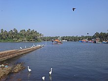
Chaliyam is a village situated at the estuary of Chaliyar (River Beypore) in Kozhikode district of Kerala, India. Chaliyam forms an island, bounded by the Chaliyar in the north, and River Kadalundi in south, and the Conolly Canal in the east. It is located just opposite to Beypore port. Chaliyam (Beypore Railway Station) was the former terminus of the South-West Line of the Madras Railway. Chaliyam is also famous for the Guinness World Records holder Muhammed Adil, a P.M who covered around seven km in the Chaliyar River with his hand and legs tied with ropes.

Contents

Different names of Chaliyam:

Chaliyam is believed to be one of the location of the founding mosques of Kerala. As per this tradition, the qazi of the mosque established at Chaliyam was Taqy ud-Din. [4] Ibn Batutah seems to have visited Chaliyam in the 14th century. He describes the settlement: "I next came to the city of Shaliat, where the Shaliats are made and hence they derive their name. This is a fine city..." [4] The first railway line in Kerala was laid in 1861 from Tirur to Chaliyam through Tanur, Parappanangadi, Vallikkunnu, and Kadalundi. [5]

Some sources allude to the presence Jewish settlements (12th and 13th centuries) in Chaliyam. [6]

As per a peace agreement between Portuguese Viceroy Nuno da Cunha and the Samutiri of Kozhikode, a Portuguese fort was constructed at Chaliyam in 1531. The Fort Chaliyam was eventually besieged, captured and destroyed by the Kozhikode forces in 1571. A certain Portuguese officer called Attaide was in charge of the fort at this time. [7] [4]

Chaliyam is also famous for the Khalasi. [7]

Beypore Railway Station, incorrectly named, at Chaliyam was the terminus of the Madras Railway (South-West Line). [4]

History

Names, routes and locations of the Periplus of the Erythraean Sea (1st century CE) Periplous of the Erythraean Sea.svg
Names, routes and locations of the Periplus of the Erythraean Sea (1st century CE)
Chaliyam harbour Chaliyam Harbour, Calicut.jpg
Chaliyam harbour

The ancient maritime port of Tyndis is identified with Kadalundi-Chaliyam-Beypore region. Tyndis was a major center of trade, next only to Muziris, between the Cheras and the Roman Empire. [8] Pliny the Elder (1st century CE) states that the port of Tyndis was located at the northwestern border of Keprobotos (Chera dynasty). [9] The North Malabar region, which lies north of the port at Tyndis , was ruled by the kingdom of Ezhimala during Sangam period. [10] According to the Periplus of the Erythraean Sea , a region known as Limyrike began at Naura and Tyndis . However, the Ptolemy mentions only Tyndis as the Limyrike's starting point. The region probably ended at Kanyakumari; it thus roughly corresponds to the present-day Malabar Coast. The value of Rome's annual trade with the region was estimated at 50,000,000 sesterces. [11] Pliny the Elder mentioned that Limyrike was prone by pirates. [12] The Cosmas Indicopleustes mentioned that the Limyrike was a source of peppers. [13] [14]

According to the Legend of Cheraman Perumals, the first Indian mosque was built in 624 AD at Kodungallur with the mandate of the last the ruler (the Cheraman Perumal) of Chera dynasty, who converted to Islam during the lifetime of Muhammad (c. 570–632). [15] [16] [17] [18] According to Qissat Shakarwati Farmad , the Masjids at Kodungallur, Kollam, Madayi, Barkur, Mangalore, Kasaragod, Kannur, Dharmadam, Panthalayini, and Chaliyam, were built during the era of Malik Dinar, and they are among the oldest Masjids in the Indian subcontinent. [19] It is believed that Malik Dinar died at Thalangara in Kasaragod town. [20]

Chaliyam, on the southern bank of Chaliyar river and the northern bank of Kadalundi River, was a part the kingdom of Parappanad during medieval period. [21] The rulers of Parappanad were vassals to the Zamorin of Calicut. [22] The headquarters of Parappanad royal family was the coastal town of Parappanangadi in present-day Malappuram district. [23] In the 15th century, Parappanad Swaroopam was divided into two - Northern Parappanad (Beypore Swaroopam) and Southern Parappanad (Parappur Swaroopam). [22] Kadalundi, Vallikkunnu, and Parappanangadi, were included in Southern Parappanad. [21] Beypore, Cheruvannur, and Panniyankara, on northern bank of Chaliyar, became Northern Parappanad. [21]

It is also known the ruler of the Kingdom of Tanur (Vettathunadu Swaroopam), had assisted the Portuguese to build a fort at the island of Chaliyam, which was a part of Southern Parappanad, and was destructed during the Siege of Chaliyam in 1571. [22] Feroke became a part of the Kingdom of Mysore in the late 18th century CE. [22] Chaliyam became a part of the Kingdom of Mysore in the late 18th century. [22] Following the Third Anglo-Mysore War and the subsequent Treaty of Seringapatam, Chaliyam became a part of Malabar District under British Raj. [22] Chaliyam was included in Eranad Taluk in the Malappuram Revenue Division of Malabar District with its Taluk headquarters at Manjeri. [24] [21] [25] Following the formation of the state of Kerala in 1956, Chaliyam became a part of Tirurangadi Revenue block of Tirur Taluk. [23] [26] On 16 June 1969, Eranad Taluk, Tirur Taluk, Tirurangadi, and Parappanangadi, were transferred to newly formed Malappuram district. [26] However, three revenue villages of Tirur Taluk, namely, Feroke, Ramanattukara, and Kadalundi, remained in Kozhikode district, as they were much closer to Kozhikode city centre. [26] However Kadalundi Nagaram beach (where Kadalundi River flows into Arabian Sea, a part of Vallikkunnu Grama Panchayat), Tenhipalam, the centre of University of Calicut, and Karippur, the site of Calicut International Airport, became parts of Malappuram. [26] Feroke, Ramanattukara, and Kadalundi are parts of Kozhikode Taluk and Kozhikode metropolitan area. [27] [28]

Important landmarks

Chaliyam lighthouse Blue Chaliyam.jpg
Chaliyam lighthouse

Suburbs and villages

See also

Related Research Articles

<span class="mw-page-title-main">Malappuram district</span> District in Kerala, India

Malappuram, is one of the 14 districts in the Indian state of Kerala, with a coastline of 70 km (43 mi). The most populous district of Kerala, Malappuram is home to around 13% of the total population of the state. The district was formed on 16 June 1969, spanning an area of about 3,554 km2 (1,372 sq mi). It is the third-largest district of Kerala by area. It is bounded by Western Ghats and the Arabian Sea on either side. The district is divided into seven Taluks: Eranad, Kondotty, Nilambur, Perinthalmanna, Ponnani, Tirur, and Tirurangadi.

<span class="mw-page-title-main">Chaliyar</span> River in Kerala, India

Chaliyar River is the fourth longest river in Kerala at 169 km in length. The Chaliyar is also known as Chulika River, Nilambur River or Beypore River as it nears the sea. Pothukal, Chungathara, Nilambur, Mampad, Edavanna, Kavanoor, Perakamanna, Areekode, Kizhuparamba, Elamaram, Cheekkode, Vazhakkad, Vazhayur, Cheruvadi, Edavannappara, Mavoor, Peruvayal, Feroke and Beypore are some of the towns/villages situated along the banks of Chaliyar. It mainly flows through Malappuram district. Its tributaries flow through both the districts of Malappuram and Kozhikode. The bank of river Chaliyar at Nilambur region is also known for natural Gold fields. Explorations done at the valley of the river Chaliyar in Nilambur has shown reserves of the order of 2.5 million cubic meters of placers with 0.1 gram per cubic meter of gold. It originates at Ilambaleri hills of Nilgiri Mountains in Nilgiris district, which is also near Wayanad-Malappuram district border. It flows mainly through the erstwhile region of Eranad, and finally empties into the Arabian Sea at Beypore port, opposite to Chaliyam harbour.

Beypore or Beypur is an ancient port town and a locality town in Kozhikode district in the state of Kerala, India. It is located opposite to Chaliyam, the estuary where the river Chaliyar empties into Arabian Sea. Beypore is part of Kozhikode Municipal Corporation. The place was formerly known as Vaypura / Vadaparappanad and also as Beydary. Tippu Sultan, ruler of Mysore, named the town "Sultan Pattanam". There is a marina and a beach while Beypore port is one of the oldest ports in Kerala, which historically traded with the Middle East. Beypore is noted for building wooden ships, known as dhows or urus in the Malayalam language. These ships were usually bought by Arab merchants for trading and fishing but are now used as tourist ships. According to Captain Iwata, founder member of the Association of Sumerian ships in Japan, Sumerian ships might have been built in Beypore. There is evidence to prove that Beypore had direct trade links with Mesopotamia and was a prominent link on the maritime silk route. The first railway line of Kerala was laid in 1861 from Tirur to Beypore (Chaliyam) passing through Tanur, Parappanangadi, Vallikkunnu, and Kadalundi.

<span class="mw-page-title-main">Malabar District</span> Administrative district of Bombay and later Madras from 1792 to 1956

Malabar District, also known as Malayalam District, was an administrative district on the southwestern Malabar Coast of Bombay Presidency (1792–1800), Madras Presidency (1800–1937), Madras Province (1937–1950) and finally, Madras State (1950–1956) in India. It was the most populous and the third-largest district in the erstwhile Madras State. The historic town of Calicut was the admisnitrative headquarters of this district.

<span class="mw-page-title-main">Feroke</span> Municipality in Kerala, India

Feroke is a Municipality and a part of Kozhikode metropolitan area under Kozhikode Development Authority (K.D.A) in the Kozhikode district of the Indian state of Kerala.

<span class="mw-page-title-main">Tanur, Malappuram</span> Municipality in Kerala, India

Tanur is a coastal town, a municipality, and a block located in Tirur Taluk, Malappuram district, Kerala, India. It is located on the Malabar Coast, 9 kilometres (5.6 mi) north of Tirur and 9 kilometres south of Parappanangadi. It is the 17th-most populated municipality in the state, the fourth-most populated municipality in the district, and the second-most densely populated municipality in Malappuram district, having about 3,568 residents per square kilometre as of the year 2011.

<span class="mw-page-title-main">Ramanattukara</span> Municipality/Suburb in Kozhikode, Kerala, India

Ramanattukara is a municipality census town in Kozhikode district in the Indian state of Kerala. This town was formerly called Kadungan Chira village. Ramanattukara is located 15 km away from Kozhikode city.

<span class="mw-page-title-main">Kadalundi River</span> River in Kerala, India

Kadalundi River (Kadalundipuzha) is one of the four major rivers flowing through Malappuram district in the Indian state of Kerala. The other three are the Chaliyar, the Bharathappuzha and the Tirur River. This rain-fed river is 130 kilometres (81 mi) long and is one of the most important rivers in the district. Kadalundi River is also the sixth longest River in Kerala. Kadalundi River passes through [Karuvarakundu, Tuvvur [Melattur, Kerala|Melattur]], Pandikkad, Manjeri, Malappuram, Panakkad, Parappur, Vengara, Tirurangadi, Parappanangadi, Vallikkunnu, and empties itself into Arabian sea at Kadalundi Nagaram in Vallikkunnu on the northwestern border of the district. It is formed by the confluence of the Olippuzha River and the Veliyar River. The Kadalundi originates from the Western Ghats at the western border of the Silent Valley and flows through the district of Malappuram. It has two main tributaries namely Olipuzha and Veliyar. Olipuzha and Veliyar merges together to become Kadalundi River near Melattur. Kadalundi River traverses through the historical regions of Eranad and Valluvanad. The Kadalundi River drains an area of 1274 km² and has a length of 120 km. The ancient port of Tyndis, which was the second-largest trading port of Chera dynasty, only after to Muziris, is identified with the mouth of this river at Vallikunnu. The Kadalundi Bird Sanctuary spreads over a cluster of islands where the Kadalundipuzha River flows into the Arabian Sea. There are over a hundred species of native birds and around 60 species of migratory birds in large numbers annually.

<span class="mw-page-title-main">Parappanangadi</span> Municipality in Kerala, India

Parappanangadi is a major town and a municipality in Tirurangadi taluk of Malappuram district, Kerala, India. It is a coastal town located close to the Arabian sea.

<span class="mw-page-title-main">Vallikkunnu</span> Village in Kerala, India

Vallikkunnu is a village in Tirurangadi Taluk of Malappuram district in the state of Kerala, India with an area of 25 km2. It is located 5 km north of Parappanangadi town and comes under the jurisdiction of Parappanangadi Police Station and Parappanangadi Judicial First Class Magistrate Court. Its latitude and longitude are 11'07" N and 7'51"E respectively. Vallikkunnu was awarded the best panchayath of Kerala in 1997. Vallikunnu is situated on Tirur-Kadalundi Road. Vallikkunnu is also a part of the Oldest Railway Line of Kerala laid in 1861 from Tirur to Chaliyam via Tanur, Parappanangadi, Vallikkunnu, and Kadalundi.

<span class="mw-page-title-main">Kadalundi</span> Village in Kerala, India

Kadalundi is a village in Kozhikode district, Kerala, India. It is a coastal village close to the Arabian Sea. Kadalundi is famous for its bird sanctuary, which is home to various migratory birds during certain seasons and has been recently declared as a bio-reserve. The Kadalundi–Vallikkunnu Community Reserve is the first community reserve in Kerala. The Kadalundi River and the Chaliyar river, two of the longest rivers of Kerala, merges with the Arabian Sea at Kadalundi. The first railway line in Kerala was laid in 1861 from Tirur to Chaliyam through Tanur, Parappanangadi, Vallikkunnu, and Kadalundi.

<span class="mw-page-title-main">Eranad</span> Erstwhile Province in Kerala, India

Eranad also known as Ernad refers to the erstwhile province in the midland area of Malabar, consisting of Malappuram and nearby regions such as Anakkayam, Manjeri, Kondotty, Nilambur, etc. Currently Eranad Taluk is a Taluk in Malappuram district. Eranad was ruled by a Samanthan Nair clan known as Eradis, similar to the Vellodis of neighbouring Valluvanad and Nedungadis of Nedunganad. The rulers of Eranad were known by the title Eralppad/Eradi. They also used the title Thirumulpad.

<span class="mw-page-title-main">Tyndis</span> Ancient Indian seaport/harbor-town mentioned in the Graeco-Roman writings

Tyndis was an ancient Indian seaport/harbor-town mentioned in the Graeco-Roman writings. According to the Periplus of the Erythraean Sea, Tyndis was located north of port Muziris in the country of the Cerobothra.

<span class="mw-page-title-main">Malabar Coast</span> Southwestern coast of the India

The Malabar Coast is the southwestern region of the Indian subcontinent. It generally refers to the western coastline of India stretching from Konkan to Kanyakumari. Geographically, it comprises one of the wettest regions of the subcontinent, which includes the Kanara region of Karnataka and all of Kerala.

Parappanad was a former feudal city-state in Malabar, India. The headquarters of Parappanad Royal family was at the town Parappanangadi in present-day Malappuram district. In 1425, the country divided into Northern Parappanad and Southern Parappanad. Southern Parappanad included parts of Tirurangadi Taluk and the town Parappanangadi. Northern Parappanad included Panniyankara, Beypore, and Cheruvannur of Kozhikkode Taluk. Parappanad royal family is a cousin dynasty of the Travancore royal family.

<span class="mw-page-title-main">Calicut (kingdom)</span> Historical kingdom in the region of Kerala

The Kingdom of Kozhikode, also known as Calicut, was the kingdom of the Zamorin of Calicut, in the present-day Indian state of Kerala. Present-day Kozhikode is the second largest city in Kerala, as well as the headquarters of Kozhikode district.

<span class="mw-page-title-main">Kozhikode South</span> Place in Kerala, India

Kozhikode South is an outgrowth of Kozhikode city in Kerala, India. Kozhikode South refers to areas like Beypore, Feroke, Areekkad, Nallalam, Cheruvannur, Ramanattukara, Kadalundi and Pantheerankavu. Suburbs like Beypore are famous for boat making.

Malappuram is one of the 14 districts in the South Indian state of Kerala. The district has a unique and eventful history starting from pre-historic times. During the early medieval period, the district was the home to two of the four major kingdoms that ruled Kerala. Perumpadappu was the original hometown of the Kingdom of Cochin, which is also known as Perumbadappu Swaroopam, and Nediyiruppu was the original hometown of the Zamorin of Calicut, which is also known as Nediyiruppu Swaroopam. Besides, the original headquarters of the Palakkad Rajas were also at Athavanad in the district.

<span class="mw-page-title-main">Kozhikode Municipal Corporation</span> Local civic body in Kozhikode, Kerala, India

Kozhikode Corporation is the municipal corporation that administers the city of Kozhikode (Calicut), Kerala. Established in 1962, it is in the Kozhikode parliamentary constituency. The first mayor was H. Manjunatha Rao. Its four assembly constituencies are Kozhikode North, Kozhikode South, Beypore and Elathur. The Corporation is headed by a Mayor and council, and manages 118.58 km2 of the city of Kozhikode, with a population of about 609,224 within that area. Kozhikode Municipal Corporation has been formed with functions to improve the infrastructure of town.

<span class="mw-page-title-main">South Malabar</span> Geographical / Historical Area in Kerala, India

South Malabar refers to a geographical area of the southwestern coast of India covering some parts of the present-day Kerala state. South Malabar covers the regions included in present-day Kozhikode taluk of Kozhikode district, the whole area of Malappuram district, Chavakkad taluk of Thrissur district, and Palakkad district, excluding parts of Chittur taluk. The Fort Kochi region of Kochi city also historically belongs to South Malabar. The term South Malabar refers to the region of the erstwhile Malabar District south to the river Korapuzha, and bears a high cultural similarity to both the Cochin and the North Malabar regions.

References

  1. 1 2 Henry Yule. Cathay and the Way Thither, Being a Collection of Medieval Notices of China, Volume 1 Taylor & Francis, 2017
  2. Hall. Secondary Cities & Urban Networking in the Indian Ocean Realm, c. 1400-1800 Lexington Books, 1955
  3. Kerala Public Service Commission
  4. 1 2 3 4 William Logan. Malabar: District Manual, Volume 1 Asian Educational Services, 1887
  5. "ആ ചൂളംവിളി പിന്നെയും പിന്നെയും..." Mathrubhumi. 17 June 2019. Archived from the original on 30 November 2020. Retrieved 19 December 2020.
  6. Jewish Virtual Library
  7. 1 2 K. M. Panikkar. A History of Kerala 1498-1801. pp. 102
  8. Coastal Histories: Society and Ecology in Pre-modern India, Yogesh Sharma, Primus Books 2010
  9. Gurukkal, R., & Whittaker, D. (2001). In search of Muziris. Journal of Roman Archaeology,14, 334-350.
  10. A. Shreedhara Menon, A Survey of Kerala History
  11. According to Pliny the Elder, goods from India were sold in the Empire at 100 times their original purchase price. See
  12. Bostock, John (1855). "26 (Voyages to India)". Pliny the Elder, The Natural History. London: Taylor and Francis.
  13. Indicopleustes, Cosmas (1897). Christian Topography. 11. United Kingdom: The Tertullian Project. pp. 358–373.
  14. Das, Santosh Kumar (2006). The Economic History of Ancient India. Genesis Publishing Pvt Ltd. p. 301.
  15. Jonathan Goldstein (1999). The Jews of China. M. E. Sharpe. p. 123. ISBN   9780765601049.
  16. Edward Simpson; Kai Kresse (2008). Struggling with History: Islam and Cosmopolitanism in the Western Indian Ocean. Columbia University Press. p. 333. ISBN   978-0-231-70024-5 . Retrieved 24 July 2012.
  17. Uri M. Kupferschmidt (1987). The Supreme Muslim Council: Islam Under the British Mandate for Palestine. Brill. pp. 458–459. ISBN   978-90-04-07929-8 . Retrieved 25 July 2012.
  18. Husain Raṇṭattāṇi (2007). Mappila Muslims: A Study on Society and Anti Colonial Struggles. Other Books. pp. 179–. ISBN   978-81-903887-8-8 . Retrieved 25 July 2012.
  19. Prange, Sebastian R. Monsoon Islam: Trade and Faith on the Medieval Malabar Coast. Cambridge University Press, 2018. 98.
  20. Pg 58, Cultural heritage of Kerala: an introduction, A. Sreedhara Menon, East-West Publications, 1978
  21. 1 2 3 4 Logan, William (2010). Malabar Manual (Volume-I). New Delhi: Asian Educational Services. pp. 631–666. ISBN   9788120604476.
  22. 1 2 3 4 5 6 Sreedhara Menon, A. (January 2007). Kerala Charitram (2007 ed.). Kottayam: DC Books. ISBN   9788126415885.
  23. 1 2 Devassy, M. K. (1965). District Census Handbook (2) - Kozhikode (1961) (PDF). Ernakulam: Government of Kerala.
  24. 1951 census handbook - Malabar district (PDF). Chennai: Government of Madras. 1953.
  25. C.A., Innes (1908). Madras District Gazetteers: Malabar and Anjengo. Government Press, Madras.
  26. 1 2 3 4 K. Narayanan (1972). District Census Handbook - Malappuram (Part-C) - 1971 (PDF). Thiruvananthapuram: Directorate of Census Operations, Kerala. p. 3.
  27. Directorate of Census Operations, Kerala. District Census Handbook, Kozhikode (PDF). Thiruvananthapuram: Directorate of Census Operations, Kerala.
  28. Directorate of Census Operations, Kerala. District Census Handbook, Malappuram (PDF). Thiruvananthapuram: Directorate of Census Operations, Kerala.