Malappuram metropolitan area | |
|---|---|
       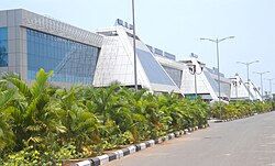 Clockwise from top: Malappuram DownHill, Ponnani Harbour, Chamravattom Regulator-cum-Bridge, Kottakkunnu Park, Payyanad stadium, Maha Kavi Moyinkutty Vaidyar Smarakam, Karipur International Airport, University of Calicut, Ponnani harbour | |
 Malappuram metropolitan area | |
| Country | India |
| State | Kerala |
| District | Malappuram |
| Area | |
• Total | 858 km2 (331 sq mi) |
| Population (2011) [2] | |
• Total | 1,729,522 |
| • Density | 2,000/km2 (5,200/sq mi) |
| Languages | |
| • Official | Malayalam, English |
| Time zone | UTC+5:30 (IST) |
| Vehicle registration | KL-10, KL-55, KL-84, KL-65, KL-53, KL-54 |
| City | Malappuram |
| Sex ratio | 1102 ♀/1000♂ |
| Literacy | 94.14% |
The Malappuram Metropolitan Area or Malappuram Urban Agglomeration is an urban agglomeration centred around the city of Malappuram, Kerala, India. [3] It is the 25th largest urban agglomeration in India and the 4th largest in Kerala.
Contents
- Constituents of the urban agglomeration
- Proposed Malappuram Municipal Corporation
- Proposed Metro rail
- See also
- References
- External links
It consists of Malappuram municipality, its adjoining municipalities, and census towns. It has a population of 1.7 million as per the 2011 Census of India. [2] It is the only city in Kerala with a million-plus urban agglomeration that is yet to be upgraded to a Municipal Corporation. It is the fastest-growing metropolitan area in the world with a 44.1% urban growth between 2015 and 2020 as per the survey conducted by Economist Intelligence Unit (EIU) based on urban area growth during January 2020. [4] As of 2011, Malappuram metropolitan area has a literacy rate of 94.14%, which is higher than the national urban average of 85%.
