
Attingal is a municipality in Thiruvananthapuram metropolitan area in Thiruvananthapuram district of Kerala state, India. It was the location of the Attingal kingdom, under Travancore. It is the headquarters of Chirayinkeezhu Taluk, and the important government institutions of the taluk such as the Taluk office, court complex, office of the deputy superintendent of Police, civil station, and treasuries are situated in Attingal. It is one of the oldest municipalities of Kerala which was constituted prior to its independence in 1924. In 1914 itself Attingal Town Improvement Authority (TIA) was formed which was the term used before the municipality regulation act of 1922. Attingal Town is located 25 kilometres (16 mi) north of Thiruvananthapuram. Attingal is the 3rd densely populated municipality in the district.

Neyyattinkara, is a significant municipal town and a prominent center for both industry and commerce, positioned at the southernmost tip of the Thiruvananthapuram metropolitan area in Trivandrum, the capital of Kerala State. It also serves as the administrative headquarters of Neyyattinkara Taluk.Nestled along the banks of the Neyyar River, one of the district's principal rivers, the town derives its name from its location, with 'Neyyatinkara' in Malayalam translating to 'the shore of the river Neyyar.' Neyyattinkara ranks as the second most densely populated municipality in the district, following Varkala. Notably, the Vizhinjam International Seaport Thiruvananthapuram is situated within Neyyattinkara Taluk."In the Vizhinjam International Seaport Thiruvananthapuram, the port international code IN NYY 1, the "NYY" represents Neyyattinkara

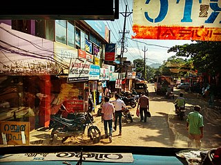
Varkala is a major coastal municipality situated in Thiruvananthapuram near the southern suburb of Kollam, in the state of Kerala.

Nedumangad is a municipal town in the Thiruvananthapuram district in the Indian state of Kerala. It is the headquarters of Nedumangad Tehsil and Nedumangad Revenue Division. It is a suburb of the extended metropolitan region of Thiruvananthapuram. It is located around 16 km (9.9 mi) to the north-east of Thiruvananthapuram on the State Highway 2. It is an important commercial center in the district. It is a growing commercial and educational hub and all important government institutions are situated in the town. The Nedumangadu market has significance in southern Kerala.

Thiruvananthapuram District is the southernmost district in the Indian state of Kerala. The district was created in 1949, with its headquarters in the city of Thiruvananthapuram, which is also Kerala's administrative centre. The present district was created in 1956 by separating the four southernmost Taluks of the erstwhile district to form Kanyakumari district. The city of Thiruvananthapuram is also known as the Information technology capital of the State, since it is home to the first and largest IT park in India, Technopark, established in 1990. The district is home to more than 9% of total population of the state.

Mattanur, also spelled Mattannur, is a town, municipality, and an aerotropolis in Kannur district, Kerala, India. Mattanur is about 27 km east of Kannur and Thalassery, two major towns of the district.
Vithura, also known as the Hill City Of Trivandrum, is located 36 km from Thiruvananthapuram capital of the Kerala state in India. Vithura is the culmination of the crossroads to many tourist, cultural, and religious centres. Surrounded by the Western Ghats (Sahyadris), Vithura is a tourist spot. The village has a good climate year-round. The Indian Institute of Science Education and Research, Thiruvananthapuram campus is situated here.
The Main Central Road popularly known as MC Road is the arterial State Highway starting from Kesavadasapuram in Trivandrum city and ends at Angamaly, a suburb of Kochi city in Ernakulam District, in the state of Kerala, India. It is designated as State Highway 1 by the Kerala Public Works Department. The highway was built by Raja Kesavadas, Dewan of Travancore, in the 1790s. Plan for a new highway called Thiruvananthapuram–Angamaly Greenfield Highway, which runs parallel to the MC Road is proposed and is under early stage of development.
Aryanadu is a village town in Thiruvananthapuram district, Kerala, India, lying under the foothills of the Agastyarkoodam of the Sahya mountains. The village is spread along the sides of Karamana River in the western ghats of Agasthya Mountains. The Aryanad Panchayath has border with Uzhamalakkal, Vellanad, Poovachal, Kuttichal, Vithura, Tholickode panchayaths. Aryanad is residing Nedumangad Taluk and Aruvikkara Legislative Assembly. It is situated around 25 km from Thiruvananthapuram. G. Steephen is the current sitting MLA of Aryanad.
Vakkom is a area of Trivandrum Metropolitan Area near Kadakkavoor in Thiruvananthapuram district of Kerala, India. It is 35 km north of Thiruvananthapuram, the state capital. Vakkom panchayat is surrounded by back waters (Kayal). Neighbouring panchayats are Anjengo, Kadakkavoor, Vettoor, Cherunniyoor and Manampoor. The towns within 9 km are Varkala and Attingal. The nearest airport is Trivandrum International Airport and Kadakkavoor (1 km) is the nearest railway station.
Kattakada is a town in Thiruvananthapuram district of Kerala. It is situated 13 km north of Neyyattinkara town, 18 km south of Nedumangad town and 20 km east of the Capital City, Thiruvananthapuram.
Malayinkeezhu is a suburb of Trivandrum, the largest city and capital of the Indian state of Kerala. It is located at the south-eastern side of Thiruvananthapuram Metropolitan Area, and is at a distance of 13 km from the heart of the city. The town is famous for the religious festival named Malayinkeezhu Aarattu. Neyyar Wildlife Sanctuary, one of the major tourist destinations in Thiruvananthapuram district is situated 17 km away from the town. The nearest airport is Trivandrum International Airport (16 km) and Balaramapuram Railway Station (9.1 km) is the nearest Railway Station. The Pincode of Malayinkeezhu Post Office is 695571 which comes under the postal circle of Neyyattinkara region.

Palode is a town in Thiruvananthapuram district in the Indian state of Kerala. Palode town is 35 km (22 mi) from Thiruvananthapuram city and 17 km (11 mi) from Nedumangad municipality.There is a Helipad in palode. Palode is surrounded by Western Ghats. Jawaharlal Nehru Tropical Botanic Garden and Research Institute is situated near Palode. Mankayam Ecotourism near Brimore is 11 km (6.8 mi) away. Brimore has tea estate and plantations make Palode a gateway for tourism destination.Thenmala is 38 km (24 mi) from Palode and Ponmudi hills is 35 km. Palode is a town in Thiruvananthapuram-Thenmala -Shenkottai State Highway 2 (Kerala). Tenkasi is 75 km (47 mi) from Palode. Palode is a town located in Nedumangad Taluk of Thiruvananthapuram district in Kerala.
Vellarada is a border village situated in Thiruvananthapuram district in the state of Kerala, India. It is 42 km from Thiruvananthapuram. It is the southernmost part of Kerala state, sharing its border with Tamil Nadu. Vellarada is said to be the threshold to the high-range areas of the eastern part of Thiruvananthapuram district. The southernmost point of Western Ghats in Kerala is near Vellarada.
Venjaramoodu is a north-east suburb of Trivandrum city, the capital of Kerala. It is 9 km (5.6 mi) east of Attingal, 11 km (6.8 mi) northwest of Nedumangad and 12 km (7.5 mi) northeast of Trivandrum City.
State Highway 47 is a State Highway in Kerala, India that starts in Attingal and ends in Nedumangadu. The highway is 18.5 km long. It is a major highway in thiruvananthapuram district that interconnect two important towns Attingal and Nedumangad, And also the Road is the only way to connect the SH 1 |Main-Central Road and National Highway 66 from the north - eastern hilly areas of Nedumangad.
Neyyattinkara is a Taluk (tehsil) located in the southern region of Thiruvananthapuram district, in the Indian state of Kerala. This taluk encompasses a total of 21 villages and one municipality, making it the southernmost taluk in the state. Notably, the Vizhinjam International Seaport Thiruvananthapuram is situated within Neyyattinkara Taluk.In the Vizhinjam International Seaport Thiruvananthapuram, the port international code IN NYY 1, the "NYY" represents Neyyattinkara

The following outline is provided as an overview of and topical guide to Kerala:
National Highway 66, commonly referred to as NH 66, is a mostly 4 lane 1640 km long busy National Highway that runs roughly north–south along the western coast of India, parallel to the Western Ghats. It connects Panvel, a city east of Mumbai (Bombay) to Cape Comorin (Kanyakumari) via Cochin (Kochi), passing through the states of Maharashtra, Goa, Karnataka, Kerala and Tamil Nadu.
This District has four types of administrative hierarchies:
