India is the most populous country in the world with one-sixth of the world's population. According to estimates from the United Nations (UN), India has overtaken China as the country with the largest population in the world, with a population of 1,425,775,850 at the end of April 2023.

Kanpur Nagar district, meaning Urban Kanpur District is one of the districts of the Uttar Pradesh state of India. It is a part of Kanpur division and its district headquarters is Kanpur. Kanpur was formerly spelled Cawnpore.

Jalandhar district is a district in Doaba region of the state of Punjab, India. The district headquarters is the city of Jalandhar.

Mohali district, officially known as Sahibzada Ajit Singh Nagar district or SAS Nagar district, is one of the twenty three districts of Punjab, a state in north-west India. It was formed in April 2006 and is 18th district of Punjab, created next to Pathankot district. This district was carved out of areas falling in Ropar and Patiala District. It is situated next to the union territory of Chandigarh, Ambala and Panchkula districts of Haryana.

North East Delhi is one of the eleven administrative district of Delhi, India. The district was established in 1997. North East Delhi borders the Yamuna River on the west, Ghaziabad District to the north and east, East Delhi to the south, and North Delhi to the west across the Yamuna. Gokalpur,Karawal Nagar, Seelampur and Yamuna Vihar are 3 sub-divisions of this district.
Edamattom is a small village on the bank of Meenachil River located in Poovarany Village in the Kottayam district, state of Kerala, India. The town lies 6.5 km (4.0 mi) southeast of Pala. Nearby towns and village include Amparanirappel, Bharananganam, Kizhaparayar, Poovarani and Vilakkumadom. Though it is a very small village, Edamattom is the home to the headquarters of Meenachil Panchayat, as well as accompanying services, including the Krishi Bhavan, the Political Associate Office of the Village (Poovarany) and the Meenachil Service Co-operative Bank. The village also contains an Ayurvedic hospital. The most prominent church in Edamattom is the St. Michael's Church. All these are considerably good landmarks for tourists and strangers, who come to Edamattom to live there. Occupationally, most residents are dependent on agriculture. The primary focus of agriculture in the village is rubber and as such the village contains a rich vegetation of rubber trees.
RannaBelagali is a Pattan Panchayat Town in the southern state of Karnataka, India. It is located in the Mudhol taluka of Bagalkot district in Karnataka
Dhavaleshwar is a village in the southern state of Karnataka, India. It is located in the Mahalingpur taluk of Bagalkot district in Karnataka. Dhavaleshwar is located on the bank of Ghataprabha river. The river bifurcates the Belgaum and Bagalkot districts. Just on the other side of the river, there is one more village which, is also known as Dhavaleshwar. This Dhavaleshwar belongs to Gokak Taluk of Belgaum district. Many politicians promised to build a bridge between both villages, but no one has initiated. The villagers grow sugar cane, which is the source of their income.
Nagaral(ನಾಗರಾಳ) is a village in the southern state of Karnataka, India. It is located in the Bilagi taluk of Bagalkot district in Karnataka. It is about 35 kilometres (22 mi) from the district headquarters of Bagalkot town and is about 5 kilometres (3.1 mi) from taluka headquarters of Bilagi and on the left bank of the Krishna River. It is famous for the Digamabareshwara temple and well educated persons.
Karajgi is a village in northern Karnataka, in central India. Administratively, it is in Afzalpur Taluka of Kalaburagi district in Karnataka.

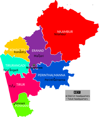
Eranad also known as Ernad refers to the erstwhile province in the midland area of Malabar, consisting of Malappuram and nearby regions such as Anakkayam, Manjeri, Kondotty, Nilambur, etc. Currently Eranad Taluk is a Taluk in Malappuram district. Eranad was ruled by a Samanthan Nair clan known as Eradis, similar to the Vellodis of neighbouring Valluvanad and Nedungadis of Nedunganad. The rulers of Eranad were known by the title Eralppad/Eradi. They also used the title Thirumulpad.

Tirur Taluk comes under Tirur revenue division in Malappuram district in the Indian state of Kerala. Its headquarters is the town of Tirur. Tirur Taluk contains four municipalities - Tanur, Tirur, Kottakkal, and Valanchery. Most of the administrative offices are located in the Mini-Civil Stations at Tirur, Kuttippuram, and Tanur. Most of the villages in present-day Tirur Taluk were parts of the medieval Kingdom of Tanur (Vettathunadu). The port of Tanur was an important port town in the southwestern coast of India during medieval period.
Ingalagi is a panchayat village in Belgaum district in the southern state of Karnataka, India.

The Malappuram Metropolitan Area or Malappuram Urban Agglomeration is an urban agglomeration centred around the city of Malappuram, Manjeri in Malappuram district, Kerala, India. It is the 25th largest urban agglomeration in India and the 4th largest in Kerala.
Karimpuzha is a gram panchayat in the Palakkad district, in the state of Kerala, India. It is a local government organisation that serves the villages of Karimpuzha-I and Karimpuzha-II.

The Malappuram district has four types of administrative hierarchies:


