Dakshina Kannada district is located in the state of Karnataka in India, with its headquarters in the coastal city of Mangalore. The district covers an area nestled in between the Western Ghats to its east and the Arabian Sea to its west. Dakshina Kannada receives abundant rainfall during the Indian monsoon. It is bordered by Udupi district to the north, Chikmagalur district to the northeast, Hassan district to the east, Kodagu to the southeast and Kasaragod district of Kerala to the south. According to the 2011 census of India, Dakshina Kannada district had a population of 2,083,625. It is the only district in Karnataka state to have all modes of transport like road, rail, water and air due to the presence of a major hub, Mangalore. This financial district is also known as the Cradle of Indian banking.
Bantwal is a suburb of Mangalore in Dakshina Kannada district, Karnataka, India, and the headquarters of Bantwal taluk. It is located 25 km (16 mi) East of Mangalore city center. BC Road-Kaikamba of Bantwal is one of the fastest developing areas in Dakshina Kannada district of Karnataka.

Kumta is a town and taluk in the Uttara Kannada district of Karnataka, India. It is one of the important stations along the Konkan Railway line running between Mumbai and Mangalore.

Sakleshpur, also known as Sakleshpura or Sakaleshapura, is a hill station town and headquarters of Sakleshpur taluk and one of the two Sub-divisional headquarters in Hassan district in the Indian state of Karnataka.
Varahi River originate and flows through Western Ghats in the Indian state of Karnataka. It is also known as Halady or Haladi river in downstream areas. It joins the Arabian sea after flowing through places like Halady, Basrur, Kundapura and Gangolli. It joins with the Souparnika River, Kedaka River, Chakra River, and Kubja River which are known by Panchagangavalli River and merges into the Arabian Sea. Pancha means five in Kannada and Samskrita and Ganga means river. According to mythology, Varaha is one of the incarnations of Lord Vishnu. Varahi is the sister of lord Varaha-vishnu

The Indian State of Karnataka is located between 11°30' North and 18°30' North latitudes and between 74° East and 78°30' East longitude.It is situated on a tableland where the Western Ghats and Eastern Ghats converge into the complex, in the western part of the Deccan Peninsular region of India. The State is bounded by Maharashtra and Goa States in the north and northwest; by the Lakshadweep Sea in the west; by Kerala in the south-west and Tamil Nadu in the south and south-east, Andhra Pradesh in the south-east and east and Telangana in the north-east. Karnataka extends to about 850 km (530 mi) from north to south and about 450 km (280 mi) from east to west.

The Western Coastal Plains is a narrow stretch of landmass lying between the western part of the Deccan plateau and the Arabian sea in India. The plains stretch from the Kutch region to Kaniyakumari at the southern tip of the Indian peninsula with the Western Ghats forming its eastern boundary. It traverses the states of Gujarat, Maharashtra, Goa, Karnataka, and Kerala.
The Kumaradhara River is a west-flowing river in the state of Karnataka, India. One of the two major rivers of Sullia, it merges with the Netravati River at Uppinangadi before flowing to the Arabian Sea. The merging of the rivers is a major event for the local villagers, as they crowd the river banks to watch what they call the "Sangama", which is a Sanskrit word for confluence.

Vitla also Vittal is a town in Bantwal taluk of Dakshina Kannada district, India, around 18 km from Bantwal in Bantwal Taluk. It is also 14 km from Puttur and 40 km from Mangalore. Vitla was an assembly constituency of Karnataka Legislative Assembly, but discontinued from 2008 elections. Agriculture is the main occupation of people in and around Vitla town. Arecanut, cocoa, pepper, Cashew and coconut are grown here. There is a regional station of Central Plantation Crops Research Institute (CPCRI) which conducts research on areca nuts, an important commercial crop in the area. It also researches cocoa growing, including its production, protection and increasing drought resistance.

The Geography of South India comprises the diverse topological and climatic patterns of South India. South India is a peninsula in the shape of a vast inverted triangle, bounded on the west by the Arabian Sea, on the east by the Bay of Bengal and on the north by the Vindhya and Satpura ranges.

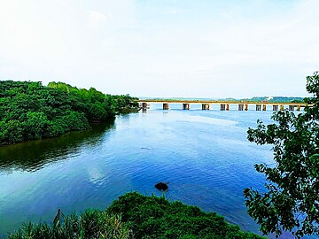
Uppinangady or Ubar is a town in the Puttur talk of Dakshina Kannada district in the state of Karnataka, India. It is surrounded by the Kumaradhara River on one side and Nethravathi River on the other. When the town's two surrounding rivers rise during the rainy season and meet, this is called the "Sangam" which is a Sanskrit word for confluence. The Sangam is a major event as people from the surrounding villages crowd the river banks to witness the merge. The population of Uppinangady is 7,172.

The Gurupura River is a river in the Karnataka state of India. It originates in the Western Ghats and is a distributary of the Netravati River, which empties into the Arabian Sea, south of Mangalore. It gets its name from the town Gurupura, situated near Mangalore. The New Mangalore Port and Mangalore Chemicals and Fertilizers are situated on its northern banks.
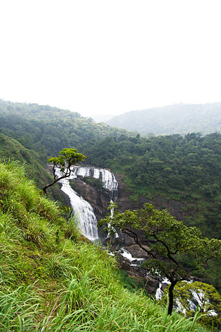
Mallalli Falls is situated in the Somwarpet Coorg District in Karnataka state in south India. The Kumaradhara River is the main watercourse for this waterfall. The Kumaradhara later flows through Kukke Subrahmanya and merges with the Netravati River at Uppinangadi, which then empties into the Arabian Sea at Mangalore.

Gangavalli River is one of the many small rivers that originates and flows entirely within the western part of state of Karnataka in India. The National Highway 66 (India) continues on the Hosur Bridge the bridge built over Gangavali River and the road continues to split the Ankola and Kumta regions to connect Uttar Kannada district to Dharwar and Mangalore area.
Bantwal taluk is a taluk of Dakshina Kannada district. The headquarters is the town of Bantwal, an eastern suburb of Mangalore.
Odadadka is a beautiful place situated near the banks of the Netravati River, in Sarapady village, Bantwal taluk, Dakshina Kannada district, Karnataka state, India. It is well connected to taluk headquarter Bantwal through Poopadikatee by road.

The city of Mangalore is proclaimed as the gateway to Karnataka and lies nestled between the blue waters of the Arabian Sea and the green, towering hills of the Western Ghats. The 184 square km city is spread out over the backwaters of the two rivers, Netravati and Gurpura.

The Shambhavi River has its origins at Kudremukh in Chikkamagaluru district of Karnataka, India. It merges with the Nandini River at Mulki, Karnataka before flowing to the Arabian Sea. This river is the main source of water to many villages nearby the river.