Aragalur is a village in Salem district, Tamil Nadu, India. It is about 6 km from Thalaivasal and 70 km from Salem.

The Vaigai is a river in the Tamil Nadu state of southern India; it passes through the towns of Theni, Madurai and Ramanathapuram. It originates in Varusanadu Hills, the Periyar Plateau of the Western Ghats range, and flows northeast through the Kambam Valley, which lies between the Palani Hills to the north and the Varushanad Hills to the south. The Vattaparai Falls are located on this river. As it rounds the eastern corner of the Varushanad Hills, the river turns southeast, running through the region of Pandya Nadu. Madurai, the largest city in the Pandya Nadu region and its ancient capital, lies on the Vaigai. The river empties into the Palk Bay near Alagankulam, close to Pamban Bridge in Ramanathapuram District.

Kollur is a village in the southern state of Karnataka, India. It is located in the Byndoor taluk of Udupi district in Karnataka.

Kollur Mookambika Temple is located at Kollur in Byndoor Taluk of Udupi District in the region of Tulunadu and in the state of Karnataka, India. It is a Hindu temple dedicated to the Mother Goddess known as Mookambika Devi. Mookambika is the union of Adipara Shakthi and Parabramha as the Linga has integrated on its left side "Maha Kali, Maha Lakshmi and Maha Saraswathi". The temple is very special because it is part of the 108 Durgalayas and 108 Shivalayas. It is situated in the foothills of Kodachadri hills, on the southern bank of Souparnika River. Being situated in the land between Gokarna and Kanyakumari, believed to be created by sage Parashurama.
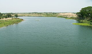
Vasishta Nadi, named after the Hindu sage Vasishtha, originates from Salem district, flows through Kurchi, Belur, Yethapur, Pethanaickenpalayam, Attur, Kattukottai, Manivizhundhan North between South, Deviyakurichi, Pattuthurai, Thalaivasal, Aragalur, Sitheri and Cuddalore district. This river flows in Cuddalore and joins Sweata Nadi before flowing into the Bay of Bengal. Dams on the river are located at Attur and Periyeri. Check dams are constructed at Attur, Thalivasal and Periyeri/Aragalur.
Varahi River originate and flows through Western Ghats in the Indian state of Karnataka. It is also known as Halady or Haladi river in downstream areas. It joins the Arabian sea after flowing through places like Halady, Basrur, Kundapura and Gangolli. It joins with the Souparnika River, Kedaka River, Chakra River, and Kubja River which are known by Panchagangavalli River and merges into the Arabian Sea. Pancha means five in Kannada and Samskrita and Ganga means river. According to mythology, Varaha is one of the incarnations of Lord Vishnu. Varahi is the sister of lord Varaha-vishnu
Thalaivasal is a town and Taluk in the Salem district of Tamil Nadu, India. It is located 18 km away from the Sub-district headquarter Attur and 70 km away from the Salem District Headquarter. It is one of the Taluks of the Salem District

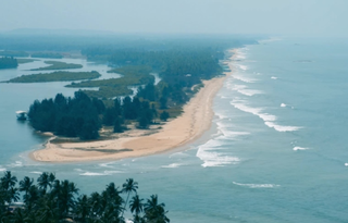
Maravanthe is a village and a beach in Byndoor Taluk, Udupi District, Karnataka, India.
Jalangi River, is a branch of the Ganges river in Murshidabad and Nadia districts in the Indian state of West Bengal. It flows into the Bhagirathi river and strengthens its lower channel, the Hooghly.
Padukone is a coastal village in Byndoor Taluk, Udupi District. It is also a surname from coastal Karnataka in India. Padukone Village surrounded by the Souparnika River. It is near famous Maravanthe. A portion of Nada Grama and Hadavu Grama is under Padukone Village. In 2016 a bridge was constructed between Maravanthe and Padukone over the Souparnika River. Part of the village is surrounded by the Souparnika River and one has to cross this river in an old wooden boat from Maraswami. Padukone is surrounded by coconut trees, water, and kudru.
Ong River is a tributary of Mahanadi river. It flows across Odisha and joins Mahanadi 240 km (150 mi) upstream of Sonepur where Tel merges. The river rises at an elevation of 457 m (1,499 ft) and runs 204 km (127 mi) before it meets Mahanadi. It drains an area of about 5,128 km2 (1,980 sq mi).
Uppunda is a large village in Byndoor Taluk with west coast of the village on the Arabian Sea in South India. The nearest city with an airport is Mangalore which is about 119 kilo-meters away. The town is reachable by water and road from Mangalore. Nearest railway station Byndoor Mookambika Road(BYNR) railway station. It is located in the Byndoor taluk of Udupi district in Karnataka.
The Bandi River, also known as the Hemawas River, is a significant river in the Pali District of Rajasthan, India. It is formed by the confluence of the Khari and Mithari Rivers near the Bombadra pickup weir. The river flows for approximately 45 km before merging with the Luni River near the village of Lakhar.
Kundapura Taluk is a taluk located in Udupi district in the Indian state of Karnataka. Kundapur town is the taluk headquarters of Kundapur Taluk.
RamanaickenPalayam is a village panchayat in the Salem district in the Indian state of Tamil Nadu.
Byndoor is a coastal town and headquarters of Byndoor Taluk in the Udupi District of Karnataka state, India. It is about 450 kilometres (280 mi) from the state capital Bengaluru and 60 kilometres (37 mi) from the Udupi district headquarters. It has an area of 67.0536 square kilometres (25.8895 sq mi) and a population of 24,957 in 2011. It lies in the foothills of Western Ghats on one side and a virgin Someshwar Beach on the other side. The Mookambika Road Byndoor railway station focuses on the pilgrims visiting the Kollur Mookambika Temple which is 28 km from Byndoor. Near by another railway station name is Bijoor, As many as 26 villages including Shiroor, Paduvari, Yadthare, Taggarse, Uppunda, Nandanavana, Kergalu, (Naikanakatte) Bijoor, Kirimanjeshwar, Ullur, Khambadakone, Heranjalu, Navunda, Badakere, Maravanthe, Hadavu, Naada, herur, Kalthodu, Golihole, Yalajith, Kollur, Jadkal, Mudoor, and Hallihole have been brought together under the Byndoor taluk.

Mookambika Road Byndoor is a railway station in coastal Karnataka in South India. Its four-letter code is BYNR. Mookambika Road Byndoor is the main railway station in the town of Byndoor in Udupi district. It serves Byndoor city which is 1 kilometre away from the station. It is the nearest railway station to the famous pilgrimage centre, Kollur Mookambika temple. The distance from Byndoor railway station to Kollur Mookambika temple is about 28 km which can be covered in 40 minutes to one hour by road. Trains from here connect the city to prominent state capitals of India like Bangalore (Karnataka), Thiruvananthapuram, Mumbai and so forth. It is also well connected to the major railway stations such as Goa (Madgoan), Udupi, Mangalore, Kasaragod and Ernakulam. Rail connectivity in Byndoor was established in 1997. A total of 34 express and passenger trains halt here; there was one originating and terminating trains at this station: Mookambika Road–Kannur Passenger train; however this service was terminated in 2017 within two years of service due to lack of revenue generation. Although the railway station caters to a lot of passengers and superfast trains on a daily basis, it does not have a siding line or passing loop. Any crossing of trains can only happen either on Bijoor or Shiroor railway stations 19 km apart.

The Old Brahmaputra River is a distributary of the Brahmaputra River in north-central Bangladesh. Historically it constituted the main stem of the Brahmaputra, however, the larger river's primary outflow was redirected via the Jamuna River after the 1762 Arakan earthquake. Today, the Old Brahmaputra has been relegated to a minor river with much less flow than its former self. The river branches off from the Brahmaputra in Jamalpur District and flows southeasterly for approximately 200 km (120 mi) before meeting the Meghna River in Kishoreganj District.

Mookambika Wildlife Sanctuary is a protected wildlife sanctuary in the southern state of Karnataka in India. It derives its name from the presiding deity "Goddess Mookambika" of the popular Kollur Mookambika Temple. The sanctuary lies in the Western Ghats in Udupi district of Karnataka. The sanctuary consists of an area of 274 km2 (106 sq mi) was notified in the year 1974, by the Government of Karnataka vide notification AFD.48.FWL.74 dated 17 June 1974.
