This article possibly contains original research .(March 2019) |
Byndoor | |
|---|---|
Town | |
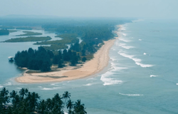 Byndoor Someshwara Beach | |
 Byndoor Location in Karnataka, India | |
| Coordinates: 13°51′58″N74°38′00″E / 13.866°N 74.6333°E | |
| Country | |
| State | Karnataka |
| District | Udupi |
| Taluk | Byndoor |
| Government | |
| • Type | Municipality |
| • Body | Town Panchayat |
| Area | |
• Total | 8.87 km2 (3.42 sq mi) |
| • Rank | 1st in (Shivamogga) |
| Elevation | 685 m (2,247 ft) |
| Population (2011) | |
• Total | 24,986 |
| • Density | 2,820/km2 (7,300/sq mi) |
| Languages | |
| • Official | Kannada |
| • Regional | Kundagannada Konkani |
| Time zone | UTC+5:30 (IST) |
| PIN | 576214 |
| Telephone code | 08254 |
| Vehicle registration | KA 20 |
| Lok Sabha constituency | Shivamogga |
| Vidhana Sabha constituency | Byndoor |
| Website | www |
Byndoor is a taluk and Town Panchayat [1] in Udupi, Karnataka, India.