
Kundapur, officially Kundapura, is a coastal town situated in the Udupi district of the state of Karnataka, India. This town was known as Coondapoor while it was part of the erstwhile South Canara district (1862–1947) of the Madras Presidency of British India. Present-day Kundapur is administered by the Kundapur Town Municipal Council and serves as the headquarters of the Kundapur Taluk of Udupi district.

The Noyyal River is a small river in Western Tamil Nadu, and a tributary of Kaveri River. It rises from the Vellingiri hills in the Western Ghats in Tamil Nadu, very closer in proximity to Kerala border, and flows through many villages and the cities of Coimbatore, and Tirupur. Then finally, the river drains into the Kaveri River at Noyyal, a village in Karur district named after the river itself. The river's basin is 180 km (110 mi) long and 25 km (16 mi) wide and covers a total area of 3,500 km2 (1,400 sq mi). Cultivated land in the basin amounts to 1,800 km2 (690 sq mi) while the population density is 120 people per km2 (311/mi2) in the countryside, and 1000 people per km2 (2590/mi2) in the cities. The area is known for its scanty rainfall and the development of the Noyyal River Tanks System to hold any overflow from the rains plus the water of the Northeast and Southwest monsoon season was ecologically important. Kausika river, which originates along the northern side of Coimbatore district in the Western Ghats along with its consequent streams, lake and pond systems is an important tributary of the river. The 173 km (107 mi) long tributary of the Kaveri River filled 32 tanks. These interconnecting tanks held the water flowing from the Noyyal.

The Tungabhadra River is a river in India that starts and flows through the state of Karnataka during most of its course, Andhra Pradesh and ultimately joining the Krishna River near Murvakonda in Andhra Pradesh

Kodachadri is a mountain peak with dense forests in the Western Ghats in South India, 78 km from Shimoga. Kodachadri is the highest peak in Shivamogga district. It is declared as natural heritage site by the Karnataka Government. and it is 13th highest peak of Karnataka.

Banswara is a town in the Banswara district in southern Rajasthan, India. The name, Banswara, came from king ‘Bansiya Bhil’
Ankola is a Town Municipal Council and a taluka in Uttara Kannada district of the Indian state of Karnataka. The name of the place is derived from a forest shrub Ankola grown on the coastal hill side and worshiped by the Halakki Vokkaligas as a totem. The town is around 33 km (21 mi) from Karwar and 86 km (53 mi) from Sirsi.
Mauranipur is a town and a municipal board in Jhansi district state of Uttar Pradesh, India. It is located in the Jhansi District. It is the largest tehsils in India by land area. This town was known for textile production, known in ancient times as Madhupuri. Because of its high density of temples, it is known by some locals as Mini-Ayoddhya. Jalvihar Mela and Viman Yatra are the most famous events in Mauranipur. The Kedareshwar temple and the Saprar Dam are located near Mauranipur.
Hosanagara is a panchayat town in Shimoga district in the Indian state of Karnataka. It is nested in western ghats of India. The World Cattle Conference with main emphasis on cow was held in month of April 2007 in Hosanagar. The different uses of cow were exhibited. Near Hosanagar there is a mutt named Sri Ramachandrapura Math, 6 km from the town.
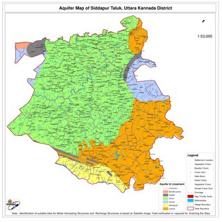
Siddapur Taluk is the destination of world famous Jog Falls. It is a part of Uttara Kannada district, Karnataka, India and is located in the midst of forest areas of Western Ghats and it is also a part of Malenadu. The taluk is full of greenery, hills and arecanut gardens developed in the valleys’. The taluk headquarters is Siddapur. Sirsi is the nearest city,
Tasgaon Tasgaon is a city in Maharashtra and Taluka in Sangli district in the Indian state of Maharashtra. Tasgaon city is developing city in Maharashtra. Tasgaon was given as Jahagir to Parshuram Bhau Tasgaonkar by Narayanrao Ballal Peshwa in 1774. Tasgaon Sansthan was lapsed by British during ruling of Shrimant Ganpatrao Tasgaonkar.
Varahi River originate and flows through Western Ghats in the Indian state of Karnataka. It is also known as Halady or Haladi river in downstream areas. It joins the Arabian sea after flowing through places like Halady, Basrur, Kundapura and Gangolli. It joins with the Souparnika River, Kedaka River, Chakra River, and Kubja River which are known by Panchagangavalli River and merges into the Arabian Sea. Pancha means five in Kannada and Samskrita and Ganga means river. According to mythology, Varaha is one of the incarnations of Lord Vishnu. Varahi is the sister of lord Varaha-vishnu
The Chakra River is a river flowing through Kundapur and Gungolli in western India. It joins with the Souparnika River, Varahi River and Kubja River known as Panchagangavali river and merges into the Arabian Sea.

Kunchikal Falls is a waterfall in India located in the Nidagodu village near Masthikatte in the Shimoga district of Karnataka state. Kunchikal Falls cascades down rocky boulders and the total height of the falls is 455 meters, according to the World Waterfall Database. Kunchikal Falls is formed by the Varahi river.
Kundapura Taluk is a taluk located in Udupi district in the Indian state of Karnataka. Kundapur town is the taluk headquarters of Kundapur Taluk.
Barahi Deula is an ancient 9th century built temple situated on the eastern coast of Odisha in Puri district, India. The barahi temple of Chaurasi is unique in more than one way. The image enshrined in this temple is considered to be one of the masterpieces among the images of the deity found all over India.
Halady, also spelled Haladi, is a small village located in Kundapura Taluk, Udupi District, Karnataka, 22 km from Taluk Centre Kundapura. Halady village consists of Halady 76 and Halady 28, which are two portions of the village.
Masthikatte is a village located in Hosanagara Taluk, Shimoga district, Karnataka, India.pincode 577425
Molahalli is a village in the Kundapur taluk of Udupi district.
Amasebailu is a village in the Kundapur taluk of Udupi, Karnataka, India.
