
Udupi is a city in the Indian state of Karnataka. Udupi is situated about 55 km (34 mi) north of the educational, commercial and industrial hub of Mangalore and more than 400 km west of state capital Bangalore by road.

Udupi district is an administrative subdivision in the Karnataka state of India, with the district headquarters in the city of Udupi. It is situated in the Canara old north Malabar coastal region. There are seven taluks, 233 villages and 21 towns in Udupi district. The three northern tehsils of Udupi, Kundapur and Karkala, were partitioned from Dakshina Kannada district to form Udupi district on 25 August 1997. Moodabidri was officially declared as new tehsil (taluk) in 2018.
Tando Jam is a town and a municipal committee of Hyderabad District in the Sindh province of Pakistan. It lies on the east of Hyderabad Taluka, about 12 kilometres northeast of the city center. As of 2017, Its population is 71,760.
Adavad, also spelt Adawad or Adwad, is a village in the Chopda Tehsil of Jalgaon District, Maharashtra, India. It is situated at the southern base of the Satpura Hills, about 30 kilometres northwest of the district seat Jalgaon, and 13 kilometres east of the subdistrict seat Chopda. As of the year 2011, it has a total population of 24,357.

Wandoor is a town in Nilambur Taluk, Malappuram District, Kerala, India. It is located on the southeast of Chaliyar River, about 24 kilometres northeast of the district seat Malappuram, and 8 km south of the taluk seat Nilambur. In the year 2011, the town has a population of 50,973.

Vazhikkadavu is a village in Nilambur taluk of Malappuram district, Kerala, India. As of 2011, it has total population of 47,322.
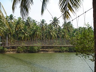
Tonse is a combined village, which includes Tonse West and Tonse East situated about 8 kilometres (5.0 mi) from Udupi on the western coast of South India, between the Arabian Sea and Western Ghats. Tonse village is about 68 kilometres (42 mi) to the north of Mangalore.

Thevalakkara is a village in the Karunagappally Taluk, Kollam District of the state of Kerala, India. It is located near the coast of the Indian Ocean, about 13 kilometres north of the district capital Kollam, and 7 kilometres southeast of the subdistrict capital Karunagappally. It contains a Devi temple along with a church and a mosque. The kadappa at Thevalakara is where ship masts (kadappa) were made for centuries. In 2011, it has a total population of 42,977.
Chinchali is a village in Raybag Taluk, Belagavi District, Karnataka, India. It is located near the state boundary with Maharashtra, approximately 84 kilometres north of the district seat Belgaum, and 10 kilometres northeast of the taluk seat Raibag. In the year 2011, the village has a population of 18,986.

Karkala, also known as Karla in Tulu language, is a town and the headquarters of Karkala taluk in the Udupi district of Karnataka, India. Located about 60 km from Mangalore in the Tulu Nadu region of the state, it lies near the foothills of the Western Ghats. Karkala has a number of natural and historical landmarks, and is a major tourist and transit destination due to its strategic location along the way to Hebri, Sringeri, Kalasa, Horanadu, Udupi, Kollur, Subrahmanya and Dharmasthala.
Mohare is a village in Bailhongal Taluk, Belagavi District of Karnataka, India. It is located near the state border with Maharashtra, about 26 kilometres east of the district seat Belgaum, and 16 kilometres northwest of the taluk seat Bailhongal. As of 2011, it has a total population of 2,365.
Badavanahalli is a village within Madhugiri Taluk, Tumakuru District, Karnataka, India. It is located at 37 kilometres north of the district seat Tumkur, and 16 kilometres west of the subdistrict seat Madhugiri. In the year 2011, it has a total population of 4,332.
Parham is a village in Jasrana Tehsil, Firozabad District, Uttar Pradesh, India. As of the year 2011, it has a population of 19,642.
Tirthpuri is a village in Ghansawangi Taluka, Jalna district, Maharashtra, India. According to the 2011 Census of India, it is home to 10,148 residents.
Chahardi is a village in Chopda Taluka, Jalgaon District, Maharashtra, India. It is located at the north of Tapti River, approximately 44 kilometres northwest of the district seat Jalgaon, and 8 kilometres southwest of the subdistrict seat Chopda. As of the year 2010, it has a total population of 11,115.
Dhamdaha is a town and the administrative Block in Purnia District, Bihar, India. It is situated in the Eastern part of Bihar, about 26 kilometres southwest of Purnia. In the year 2011, the village has a total population of 37,987.
Itawa is a town in Pipalda Tehsil, Kota District, Rajasthan, India. It is located near the state boundary with Madhya Pradesh, about 79 kilometres northeast of the district seat Kota, and 5 kilometres southwest of the tehsil seat Pipalda. As of 2011, the town has a population of 26,741.
Jale, or Jalley, is a town and the administrative center of Jale Block, Darbhanga District, Bihar, India. It is located to the north of Bagmati River, about 32 kilometres northwest of the district capital Darbhanga. The town was named after Jaleshwari sthan which is a pilgrimage site in rural area of Darbhanga. In the year 2011, it has a total population of 37,256.
Morai is a village in Ambattur Taluk, Tiruvallur District, Tamil Nadu, India. It is located in the western suburb of Chennai, about 23 kilometres away from the city center. As of 2011, it had a total population of 10,873.
Lingga is a town located in Sri Aman Division, Sarawak, Malaysia. It is located in East Malaysia, about 50 kilometres northwest of the division capital Simanggang. As of the year 2020, it had a population of 4,073.

