Ballari in the eponymous Ballari district, is a city in the state of Karnataka, India.

Chikmagalur, officially Chikkamagaluru is an administrative district in the Malnad subregion of Karnataka, India. Coffee was first cultivated in India in Chikmagalur. The hills of Chikmagalur are parts of the Western Ghats and the source of Tunga and Bhadra rivers. Mullayanagiri, the highest peak in Karnataka is located in the district. The area is well known for the Sringeri Mutt that houses the Dakshina Peeta established by Adi Shankaracharya.

Kudremukha is the name of a mountain range and an individual mountain peak located in Chikmagalur district, in Karnataka, India. It is also the name of a small hill station and iron ore-mining town situated near the mountain, about 20 kilometres from Kalasa in Kalasa Taluk. The name Kuduremukha literally means "horse-faced" in Kannada and refers to a particular picturesque view of a side of the mountain that resembles a horse's face. It was also referred to as 'Samseparvata', historically since it was approached from Samse village. Kuduremukha is Karnataka's 2nd highest peak after Mullayanagiri and 26th highest peak in western ghats. The nearest International Airport is at Mangalore which is at a distance of 99 kilometres.
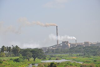
Bhadravati or Bhadravathi is an industrial city or Steel Town and taluk in the Shivamogga District of the Indian state of Karnataka. It is situated at a distance of about 255 kilometres (158 mi) from the state capital Bengaluru and at about 20 kilometres (12 mi) from the district headquarters, Shivamogga. The town is spread over an area of 67.0536 square kilometres (25.8895 sq mi) and has a population of 151,102 as per the census held in 2011.

Chikmagalur is a city and the headquarters of Chikmagalur district in the Indian state of Karnataka. Located on the foothills of the Mullayanagiri peak of the Western Ghats, the city attracts tourists from around the world for its pleasant and favourable hill station climate, tropical rainforest and coffee estates. The pristine Baba Budangiri lies to the north of Chikmagalur where it's believed Baba Budan first introduced coffee to India.

Sirsi is a city and a taluk headquarter in Uttara Kannada district of Karnataka state in India. It was also known as Kalyana Pattana during the Sonda Dynasty. It is a tourist destination with evergreen forest and waterfalls and is also a commercial centre. The main businesses around the city are mostly subsistence and agriculture-based. Areca nut or betel nut, locally known as Adike, is the primary crop grown in the nearby villages, making it one of the major trading centres for areca nut. The region is also known for spices such as cardamom, pepper, betel leaves, and vanilla. The major food crop is paddy. This city is about 72.2 km away from the city of Sagara and 144.4 km away from Shimoga.

Horanadu, also known as Sri Kshetra Horanadu, is a Hindu holy town and a Panchayat village located in kalasa taluk of Chikkamagaluru district, Karnataka, India. The town is famous for the Annapoorneshwari Temple. The main idol of the goddess is believed to have been consecrated by the sage Agastya; the new processional idol was consecrated in the temple in 1973. Horanadu has an elevation of 831 m (2,726 ft)

The Bhadra is a river in Karnataka state in southern India.
Bhadra is a city and a municipality in Hanumangarh district in the state of Rajasthan, India.

Sadri is a municipality in the Pali district of Rajasthan, India. It is considered the gateway to Marwar from Mewar. Sadri is one of the main places of worship for the Jain community. Ranakpur Temple and Shri Parshuram Mahadev Mandir are located in Sadri, which became a municipality in 1961. Bhadras is located 3 km from Sadri along the Suhai river.

Bhadra Wildlife Sanctuary is a protected area and tiger reserve as part of the Project Tiger, situated in Chikkamagaluru district, 23 km (14 mi) south of Bhadravathi city, 38 km (24 mi) 20 km from Tarikere town, northwest of Chikkamagaluru and 283 km from Bengaluru city in Karnataka state, India. Bhadra sanctuary has a wide range of flora and fauna and is a popular place for day outings. The 1,875 m (6,152 ft) above MSL Hebbe Giri is the highest peak in the sanctuary.
Lingadahalli is a village and a hobli in Tarikere Taluk, Chikmagalur district, Karnataka, India. Lingadahalli is one of the prominent pre-historic sites in Karnataka state. The location code number of Lingadahalli as per census of India 2011 are, 609336 and 609334 (kaval).

Kalasa is a taluk located in Chikmagalur district in Karnataka. Kalasa is home to the Kalaseshwara Temple dedicated to Lord Shiva. Kalasa lies 92 Kilometres South-west of Chickmagalur and is located on the banks of the Bhadra River. Kannada language is spoken here.

Charmadi Ghat (Charmady) is a ghatti beginning from Belthangady taluk of Dakshina Kannada and ending in Mudigere taluk of Chikmagalur. It is one of the points in Western ghats through which motorable road passes connecting Dakshina Kannada with Chikmagalur district. The section of ghat is known by the name of Charmadi Ghat. It lies on National Highway 73 which connects Mangalore to Tumkur. The nearest places are Charmadi village, Ujire, Belthangady, Puttur, Kottigehara, Balur and Kalasa and Banakal.

Balehonnur is a village in Narasimharajapura taluk, of Chikkamagaluru district in the Indian state of Karnataka. It comes under the jurisdiction of B.Kanbur Grama Panchayath. As per census survey 2011, its location code number is 609097.

Anegundi, previously called Kishkindha, is a village in Gangavathi, Koppal district, in the Indian state of Karnataka. It is older than Hampi, situated on the northern bank of the Tungabhadra River. Nimvapuram, a nearby village, has a mount of ash believed to be the cremated remains of the monkey king Vaali.

Kuttikattu Sree Bhadra Kali Devi Temple is one of the Bhadrakali temples in Cherthala, Alappuzha district, Kerala. It is about 1 kilometer west of the Arthungal bypass of NH 47 at Cherthala.
The Bhadra Dam or Lakkavalli Dam, which has created the Bhadra Reservoir, is located on the Bhadra River a tributary of Tungabhadra River. Bhadra Dam is located in the border of Bhadravathi and Tarikere, in the western part of Karnataka in India. The benefits derived from the reservoir storage are irrigation with gross irrigation potential of 162,818 hectares, hydro power generation of 39.2 MW, drinking water supply and industrial use. The dam commissioned in 1965 is a composite earth cum masonry structure of 59.13 metres (194.0 ft) height with length of 1,708 metres (5,604 ft) at the crest level, which submerges a land area of 11,250.88 hectares.
Bhadra Fort is situated in the walled city area of Ahmedabad, India. It was built by Ahmad Shah I in 1411. With its well carved royal palaces, mosques, gates and open spaces, it was renovated in 2014 by the Amdavad Municipal Corporation (AMC) and the Archaeological Survey of India (ASI) as a cultural centre for the city.

Didaur, also spelled Dedaur, is a village in Sataon block of Rae Bareli district, Uttar Pradesh, India. It is located 8 km from Raebareli on the road to Unnao, just east of the intersection with the road to Lalganj. It is near the right bank of the Sai river. As of 2011, Didaur has a population of 4,781 people, in 900 households. The village hosts two annual festivals: one is the Badhwapur-ka-Mela, which is dedicated to the worship of Nag Devta and is held on Bhadra Sudi 5, and the other is the Jhurhapur-ka-Mela, which is dedicated to worship of Rama and falls on Phalguna Sudi 8.