
Shimoga, officially Shivamogga, is a city and the district headquarters of Shimoga district in the central part of the state of Karnataka, India. The city lies on the banks of the Tunga River. Being the gateway for the hilly region of the Western Ghats, the city is popularly nicknamed the "Gateway of Malnad". The population of Shimoga city is 322,650 as per 2011 census. The city has been selected for the Smart Cities project, standing in the fourth position in the state and 25th in the country as of November 2020.

Mandya is a city in the state of Karnataka. It is the headquarter of Mandya district and is located 45 kilometres (28 mi) from Mysore and 100 kilometres (62 mi) from Bangalore.

Davanagere is a city in the centre of the southern Indian state of Karnataka. It is the seventh largest city in the state, and the administrative headquarters of eponymous Davangere district. Hitherto being a cotton hub and hence popularly known before as the Manchester of Karnataka, the commercial ventures of the city is now dominated by education and agro-processing industries. Davanagere became a separate district in 1997, when it was separated from the erstwhile undivided district of Chitradurga for administration conveniences. Davanagere is known for rich culinary traditions which encompass the diversity of entire Karnataka's dishes due to its geographical position in the state as its centre. Notable among them is its aromatic benne dose.

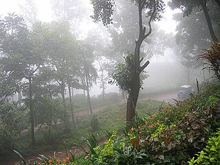
Chikmagalur, officially Chikkamagaluru is an administrative district in the Malnad subregion of Karnataka, India. Coffee was first cultivated in India in Chikmagalur. The hills of Chikmagalur are parts of the Western Ghats and the source of Tunga and Bhadra rivers. Mullayanagiri, the highest peak in Karnataka is located in the district. The area is well known for the Sringeri Mutt that houses the Dakshina Peeta established by Adi Shankaracharya.
Kemmannugundi is a hill station in Tarikere taluk of Chikkamagaluru district in the state of Karnataka, India. It is at the elevation of 1434m above sea level, with its peak at 1863m. This was the summer retreat of Krishnaraja Wodeyar IV, and as a mark of respect to the king, it is also known as Sri Krishnarajendra Hill Station. The station is ringed by the Baba Budan Giri Range, with cascades, mountain streams, and lush vegetation. Kemmangundi has ornamental gardens and mountains and valleys views.

Mysore division, officially Mysuru division, is an administrative division in the southern Indian state of Karnataka. It is one of four administrative divisions in Karnataka, the others being Bangalore division, Belagavi division, and Kalaburagi division. Mysore division comprises eight districts of Karnataka, namely, Chamarajanagar, Chikmagalur, Dakshina Kannada, Hassan, Kodagu, Mandya, Mysore and Udupi district. The city of Mysore is the administrative headquarters of the division. Mysore division covers parts of historical Old Mysore region and southern part of Coastal Karnataka.The total area of the division is 43,503 sq.km. The total population as of 2011 census is 12,563,598.

Hassan is a city in the southern part of the Indian state of Karnataka. It is the headquarters of Hassan district. The city is situated midway between Bangalore and Mangalore on National Highway 75.
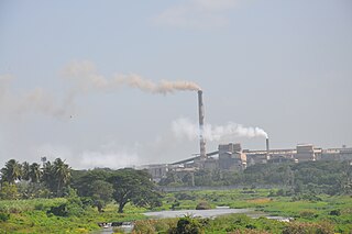
Bhadravati or Bhadravathi is an industrial city or Steel Town and taluk in the Shivamogga District of the Indian state of Karnataka. It is situated at a distance of about 255 kilometres (158 mi) from the state capital Bengaluru and at about 20 kilometres (12 mi) from the district headquarters, Shivamogga. The town is spread over an area of 67.0536 square kilometres (25.8895 sq mi) and has a population of 151,102 as per the census held in 2011.

Hassan is one of the 31 districts of Karnataka, India. The district headquarter is Hassan. It was part of Manjarabad Faujdari a.k.a Patnada Rayada between 1832-81. In 1882, it was reduced into a sub-division under erstwhile Kadur district. But in 1886, the Hassan district was restored to its current form.
The economy of South India after independence in 1947 conformed to a socialist framework, with strict governmental control over private sector participation, foreign trade and foreign direct investment (FDI). Through 1960–1990, South Indian economies experienced mixed economic growth. In the 1960s, Kerala achieved above-average economic growth, while Andhra Pradesh's economy declined during this period. Similarly, Kerala experienced an economic decline in the 1970s while the economies of Tamil Nadu, Andhra Pradesh, and Karnataka consistently exceeded national average growth rates after 1970. South India first started to overtake the rest of India economically in the 1980s. Andhra Pradesh, Tamil Nadu and Karnataka were noted by some to be more reform-oriented in terms of economic policy when compared to other Indian states. Over the last decade South India has grown at 8% annually. Future economic growth will be shackled by a relatively low proportion of the active age population to the number of dependents. Today, South India has about 20% of India's population, and contributes about 31% of India's GDP; it is projected to contribute 35% by 2030.

Tumkur is a city located in the southern part of Indian state of Karnataka. It is situated at a distance of 70 km (43 mi) northwest of Bangalore, the state's largest city and capital, along NH 48 and NH 73. It is the headquarters of the Tumakuru district. It is located at an altitude of 835 m (2739.5 ft).

Holenarasipura is a town and taluk in Hassan district of Karnataka. The town is situated on the banks of the Hemavati, one of the tributaries of the Kaveri.
Harapanahalli is a town, taluk and is one of the two sub-divisional headquarter in the Vijayanagara District in the Indian state of Karnataka.

Sakleshpur, also known as Sakleshpura or Sakleshapura, is a hill station town and headquarters of Sakleshpur taluk and one of the two Sub-divisional headquarters in Hassan district in the Indian state of Karnataka.
Tarikere is a town, a taluk and is one of the two Subdivisional headquarter in the Chikmagalur district of Karnataka state, India. It is popularly known as gateway of Malnad because the Malnad area starts from here. The town's name is derived from the number of water tanks which surround it.

Karnataka, the sixth largest state in India, has been ranked as the third most popular state in the country for tourism in 2014. It is home to 507 of the 3600 centrally protected monuments in India, second only to Uttar Pradesh. The State Directorate of Archaeology and Museums protects an additional 752 monuments and another 25,000 monuments are yet to receive protection.

Karnataka is one of the highest economic growth states in India with an expected GSDP growth of 9.5% in the 2021–22 fiscal year. The total expected GSDP of Karnataka in 2022–2023 is about $240 billion. Karnataka recorded the highest growth rates in terms of GDP and per capita GDP in the last decade compared to other states. In 2008–09, the tertiary sector contributed the most to GSDP, followed by the secondary sector, and the primary sector.

Cherupuzha is a town in Kannur district, Kerala, India. It is the headquarters of the Cherupuzha Panchayat which is a special grade panchayat in Kerala.

Balehonnur is a village in Narasimharajapura taluk, of Chikkamagaluru district in the Indian state of Karnataka. It comes under the jurisdiction of B.Kanbur Grama Panchayath. As per census survey 2011, its location code number is 609097.
Mangalore's location in the Indian state of Karnataka makes it accessible by all forms of transport: road, rail, air and sea. It is the largest city in the Coastal Karnataka region, and is the only city in Karnataka and one among the six cities in India to have an International Airport, a Major Seaport, railway & road connectivities. It is the second prominent city of Karnataka after the state capital Bangalore in all aspects. It is one of the fastest developing cities in India.


