Dakshina Kannada district is located in the state of Karnataka in India, with its headquarters in the coastal city of Mangalore. It is part of the larger Tulu Nadu region. The district covers an area nestled in between the Western Ghats to its east and the Arabian Sea to its west. Dakshina Kannada receives abundant rainfall during the Indian monsoon. It is bordered by Udupi district to the north, Chikmagalur district to the northeast, Hassan district to the east, Kodagu to the southeast and Kasaragod district of Kerala to the south. According to the 2011 census of India, Dakshina Kannada district had a population of 2,083,625. It is the only district in Karnataka state to have all modes of transport like road, rail, water and air due to the presence of a major hub, Mangalore. This financial district is also known as the Cradle of Indian banking.

Chikmagalur, officially Chikkamagaluru is an administrative district in the Malnad subregion of Karnataka, India. Coffee was first cultivated in India in Chikmagalur. The hills of Chikmagalur are parts of the Western Ghats and the source of Tunga and Bhadra rivers. Mullayanagiri, the highest peak in Karnataka is located in the district. The area is well known for the Sringeri Mutt that houses the Dakshina Peeta established by Adi Shankaracharya.
Thodikana is an Indian village nestled in the foothills of the Western Ghats in southern Karnataka. It is in the Sullia taluk of Dakshina Kannada district, about 100 km from Mangalore city. This village has much greenery and attracts visitors with its cultural and natural sites.

Mudigere is a Town and Taluk in Chikmagalur district in the Indian state of Karnataka. It is 30 km from the district headquarters.

Sakleshpur, also known as Sakleshpura or Sakleshapura, is a hill station town and headquarters of Sakleshpur taluk and one of the two Sub-divisional headquarters in Hassan district in the Indian state of Karnataka.
Kakkinje is a village located in Dakshina Kannada District of Karnataka State in India and comes under Belthangady Taluk. The village incorporates an eclectic mix of religious denominations, including Christians, Hindus and Muslims. This place is located on the foothills of Western Ghats. Agriculture is the main income of this place. Traditional crops like paddy and arecanut are cultivated in large scale. Recent times rubber cultivation is widely undertaken due to the efforts of Rubber Board of India. Christian settlers from Central Travancore are seen in large numbers.

Ghat Roads are access routes into the mountainous Western and Eastern Ghats, mountain ranges of the Indian subcontinent. These roads are remarkable feats of engineering, and most were constructed during the British Raj. Ghat Roads were built to connect to the hill stations established in the mountains for residents to avoid summer heat. They generally served to connect coastal areas with the upper Deccan Plateau.
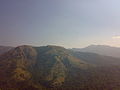
Banakal is a Malnad town in Mudigere Taluk, Chikkamagaluru district of Karnataka, India. This town is situated atop the Charmadi hills in the Western Ghats section. The Western Ghats is one amongst twenty-five identified hot spots for biodiversity conservation in the world. Banakal is surrounded by coffee estates and paddy fields and known for its pleasant weather throughout the year. Banakal town is the headquarters of Banakal Hobli.

Kalasa is a taluk located in Chikmagalur district in Karnataka. Kalasa is home to the Kalaseshwara Temple dedicated to Lord Shiva. Kalasa lies 92 Kilometres South-west of Chickmagalur and is located on the banks of the Bhadra River. Kannada language is spoken here.

Ujire is a town near Dharmasthala. It is in Belthangady taluk of Dakshina Kannada district. Ujire is an important junction for travelers in this region. The road at Ujire deviates to Dharmasthala, Kottigehara and Belthangady.
Shiradi is a village on the Mangalore to Bangalore section of National Highway 75. The village is situated in Puttur taluk of Dakshina Kannada district. The nearest town is Nelliyadi which is at a distance of approximately 15 km. The ghat is a section of Western ghats through which NH 75 passes is called Shiradi Ghat.
Kadaba is a taluk in Dakshina Kannada district of Karnataka, India. It is located 82 km towards East from District headquarters Mangalore, 31 km from Puttur, 38 km from Sullia and 272 km from State capital Bangalore.

Kottigehara is a village located atop the Charmadi ghat in Mudigere taluk of Chikkamagaluru district of Karnataka state, India. It is located 16 km from Mudigere town.The nearest railway stations are at Chikkamagaluru (47 km), Hassan (87 km) and Mangaluru (104 km) respectively. The nearest international airport is Mangalore International Airport. Kottigehara is located at an elevation of 962 m (3,156 ft) above Mean Sea Level.
Sampaje is a district border village of Kodagu in the southern state of Karnataka, India. It is located in the Madikeri taluk. It lies on National Highway - 275 which connects Mangalore city in Dakshina Kannada district with Madikeri, Mysuru and Bengaluru.

Karkala, also known as Karla in Tulu language, is a town and the headquarters of Karkala taluk in the Udupi district of Karnataka, India. Located about 60 km from Mangalore in the Tulu Nadu region of the state, it lies near the foothills of the Western Ghats. Karkala has a number of natural and historical landmarks, and is a major tourist and transit destination due to its strategic location along the way to Hebri, Sringeri, Kalasa, Horanadu, Udupi, Kollur, Subrahmanya and Dharmasthala.
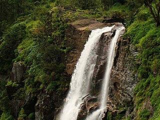
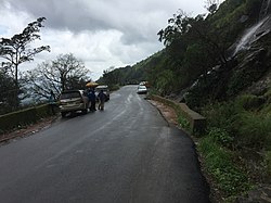
Bandaje falls, also known as Bandaje Arbi falls is a waterfall located in the Kudremukha section of the Western Ghats in the Belthangady taluk of Dakshina Kannada district, Karnataka. The waterfalls can be reached only by undertaking trekking in thick forests and grass lands with the help of local guides and in summer the waterfalls goes dry. The height of waterfalls is about 200 feet.
Patrame is a small, rural panchayat village on the left (east) bank of the Netravati River in Karnataka, India. Administratively, it is under Belthangady taluk, Dakshina Kannada district, Karnataka. Patrame is the only village in its gram panchayat. The village of Patrame is 26 km from its taluk headquarters Belthangady, and 8 km by road from Dharmasthala.

National Highway 73 is a National Highway in India. This highway runs in the Indian state of Karnataka. It starts from sea port city of Mangaluru ( Mangalore) and ends at Tumakuru. Even though named as national highway the road is narrow and prone to landslips and falling of trees in Charmady ghat section of Western ghats. This highway was previously part of national highways 48, 234 and 206 but subsequent to rationalisation of national highway numbers of India by Gazette notification on 5 March 2010 it was changed to National Highway 73.

Devimane is a hill station and high-altitude village in Sirsi taluk of Malenadu region in Karnataka, India. The road to reach the village is named Devimane Ghat, and lies in NH 766E ultimately connecting Malenadu city Sirsi and Karavali town Kumta. Being under the lush forest zone in Uttara Kannada District, it consists of 10 hairpin curves with a well-engineered road that reduces the risk of accidents. The road's elevation ranges from 25 to 567 metres. A temple of Goddess Durga Devi is at the beginning of the road at elevation 429m. The ghat section was named after the temple, "Devimane", meaning "the home of goddess Devi". There are 5 hairpins curves between Devimane Temple and Sampakhanda.
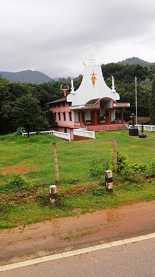
Shishila is a village located at the base of Western Ghats in Belthangady taluk of the Karnataka State, India. The main attraction of the village is a temple dedicated to Lord Shishileshwara.