
Udupi is a city in the Indian state of Karnataka. Udupi is situated about 55 km (34 mi) north of the educational, commercial and industrial hub of Mangalore and more than 400 km west of state capital Bangalore by road.

Chikmagalur, officially Chikkamagaluru is an administrative district in the Malnad subregion of Karnataka, India. Coffee was first cultivated in India in Chikmagalur. The hills of Chikmagalur are parts of the Western Ghats and the source of Tunga and Bhadra rivers. Mullayanagiri, the highest peak in Karnataka is located in the district. The area is well known for the Sringeri Mutt that houses the Dakshina Peeta established by Adi Shankaracharya.

The Tungabhadra River is a river in India that starts and flows through the state of Karnataka during most of its course, Andhra Pradesh and ultimately joining the Krishna River near Murvakonda in Andhra Pradesh
Kemmannugundi is a hill station in Tarikere taluk of Chikkamagaluru district in the state of Karnataka, India. It is at the elevation of 1434m above sea level, with its peak at 1863m. This was the summer retreat of Krishnaraja Wodeyar IV, and as a mark of respect to the king, it is also known as Sri Krishnarajendra Hill Station. The station is ringed by the Baba Budan Giri Range, with cascades, mountain streams, and lush vegetation. Kemmangundi has ornamental gardens and mountains and valleys views.

Mysore division, officially Mysuru division, is an administrative division in the southern Indian state of Karnataka. It is one of four administrative divisions in Karnataka, the others being Bangalore division, Belagavi division, and Kalaburagi division. Mysore division comprises eight districts of Karnataka, namely, Chamarajanagar, Chikmagalur, Dakshina Kannada, Hassan, Kodagu, Mandya, Mysore and Udupi district. The city of Mysore is the administrative headquarters of the division. Mysore division covers parts of historical Old Mysore region and southern part of Coastal Karnataka.The total area of the division is 43,503 sq.km. The total population as of 2011 census is 12,563,598.
Arsikere is a city and taluka in the Hassan district in the state of Karnataka, India. It is the second largest city in Hassan district, demographically. Arsikere city municipal council consists of 35 wards. This region is known for its coconut production and is also called Kalpataru Nadu. Arsikere Junction is a major railway junction in the South Western Railway which links Mangalore and Mysore to North Karnataka and a central place for tourists who visit nearby places that do not have rail access, such as Belur, Halebidu and Shravanabelagola, Harnahalli, and Kodimata.

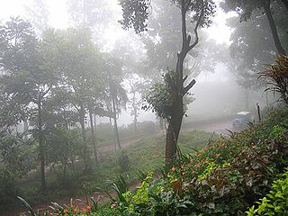
Chikmagalur is a city and the headquarters of Chikmagalur district in the Indian state of Karnataka. Located on the foothills of the Mullayanagiri peak of the Western Ghats, the city attracts tourists from around the world for its pleasant and favourable hill station climate, tropical rainforest and coffee estates. The pristine Baba Budangiri lies to the north of Chikmagalur where it's believed Baba Budan first introduced coffee to India.

Kaduru, also known as Kadur, is second largest town in the district and a Taluk in Chikmagalur district, in Karnataka. It is located at 13.553345°N 76.011260°E in the rain shadow region of western ghats. Most of the taluk is dry, unlike much of the district. Kadur is known for areca nut and also coconut production.

Kolar or Kolara is a city in the Indian state of Karnataka. It is the headquarters of Kolar district. The city is known for its milk production and gold mines. It is also known for the Someshwara and Kolaramma temples.

Mudigere is a Town Panchayath and Taluk in Chikmagalur district in the Indian state of Karnataka. It is 30 km from the district headquarters.

Sakleshpur, also known as Sakleshpura or Sakleshapura, is a hill station town and headquarters of Sakleshpur taluk and one of the two Sub-divisional headquarters in Hassan district in the Indian state of Karnataka.
Tarikere is a town, a taluk and is one of the two Subdivisional headquarter in the Chikmagalur district of Karnataka state, India. It is popularly known as gateway of Malnad because the Malnad area starts from here. The town's name is derived from the number of water tanks which surround it.
Lingadahalli is a village and a hobli in Tarikere Taluk, Chikmagalur district, Karnataka, India. Lingadahalli is one of the prominent pre-historic sites in Karnataka state. The location code number of Lingadahalli as per census of India 2011 are, 609336 and 609334 (kaval).
Chowlahiriyur is a village and a hobli in Ajjampura taluk of Chikmagalur district, in the state of Karnataka, India.

Kalasa is a taluk located in Chikmagalur district in Karnataka. Kalasa is home to the Kalaseshwara Temple dedicated to Lord Shiva. Kalasa lies 92 Kilometres South-west of Chickmagalur and is located on the banks of the Bhadra River. Kannada language is spoken here.

Balehonnur is a village in Narasimharajapura taluk, of Chikkamagaluru district in the Indian state of Karnataka. It comes under the jurisdiction of B.Kanbur Grama Panchayath. As per census survey 2011, its location code number is 609097.
Aadigere is a village in the southern state of Karnataka, India. It is located in the Kadur taluk of Chikkamagaluru district in Karnataka.

Agrahara, Kadur is a village in the southern state of Karnataka, India. It is located in the Kadur taluk of Chikkamagaluru district in Karnataka.

Sagara is a city located in the Indian state of Karnataka. It is also a sub divisional and a taluk headquarters. Located in the Sahyadri Mountain range on the banks of river Varada, it is known for its proximity to Jog Falls and to the historical places of Ikkeri, Keladi and Varadamoola. The river Varada originates near Varada-moola. Sagara subdivision consists of Sagara, Soraba, Hosanagara and Shikaripur taluks.
Yagati Suryanarayana Venkatesha Datta is an Indian politician and former member of Karnataka Legislative Assembly from the Kadur seat in 2013 on the Janata Dal (Secular) ticket. Later on 14 January 2023, Datta who had earlier joined INC, reverted to JD(S) on April 13, 2023, in the presence of HD Revanna anda MP Prajwal Revanna. His return was, however, opposed by HD Kumarswamy, who left the matter to Revanna.
