This article needs additional citations for verification .(March 2022) |
Ballari | |
|---|---|
 Ballari city | |
 Ballari in Karnataka | |
| Coordinates: 15°06′N76°55′E / 15.100°N 76.917°E | |
| Country | |
| State | |
| District | Ballari |
| Government | |
| • Type | Municipal Corporation |
| • Body | Ballari City Corporation |
| • Mayor | Shwetha B |
| • Commissioner | G Khaleel Sab [1] |
| Area | |
| 167.38 km2 (64.63 sq mi) | |
| • Rural | 1,609.68 km2 (621.50 sq mi) |
| Elevation | 485 m (1,591 ft) |
| Population (2011) | |
| 410,445 [2] | |
| • Rank | 95th (India) 5th (Karnataka) |
| • Density | 2,452.2/km2 (6,351.1/sq mi) |
| • Rural | 360,484 |
| Demonym | Ballarians |
| Time zone | UTC+05:30 (IST) |
| Postal Index Number | 583101, 583102, 583103, 583104, 583105, 583152 [3] |
| Telephone code | (+91)8392 |
| ISO 3166 code | IN-KA |
| Vehicle registration | KA-34 |
| Official language | Kannada [4] |
| Sex ratio | 1.04 [5] ♂/♀ |
| Literacy | 79% [5] |
| Website | ballaricity |
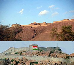
Ballari (Kannada: [bɐɭːaːri] , formerly Bellary [6] ) is a city in the Ballari district in state of Karnataka, India.
Contents
- History
- Geography
- Climate
- Demographics
- Languages
- Economy
- Industries
- Transport
- Roadways
- Rail
- Air
- Education
- Notable people
- References
- Maps
- General
- External links
Ballari houses many steel plants such as JSW Vijayanagar, one of the largest in Asia. Ballari district is also known as the ‘Steel city of South India’. Ballari is also the headquarters for Karnataka Gramina Bank which almost has more than 1100 + branches in Karnataka. [7]


