Related Research Articles

Kundapra, officially Kundapura, is a coastal town situated in the Udupi district of the state of Karnataka, India. This town was known as Coondapoor while it was part of the erstwhile South Canara district (1862–1947) of the Madras Presidency of British India. Present-day Kundapur is administered by the Kundapur Town Municipal Council and serves as the headquarters of the Kundapur Taluk of Udupi district.

Udupi district is an administrative subdivision in the Karnataka state of India, with the district headquarters in the city of Udupi. It is situated in the Canara old north Malabar coastal region. There are seven taluks, 233 villages and 21 towns in Udupi district. The three northern tehsils of Udupi, Kundapur and Karkala, were partitioned from Dakshina Kannada district to form Udupi district on 25 August 1997. Moodabidri was officially declared as new tehsil (taluk), separated from Karkala with effect from 11 January 2018.

Kollur is a village in the southern state of Karnataka, India. It is located in the Byndoor taluk of Udupi district in Karnataka.

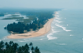
Maravanthe is a village and a beach in Byndoor Taluk, Udupi District, Karnataka, India.
Bijoor is a Village near to Byndoor in the southern state of Karnataka, India. It is located in the Byndoor taluk of Udupi district in Karnataka.Bijur Gram Panchayat consists of a single village consisting of 4 broad wards. The village is bounded by the town of Byndoor to the north, Kergalu to the south, Kaltodu to the east and Uppunda village to the west. Bijoor village is located in 6 km from the taluk center and Hobali. The village has one high school, four higher primary schools and one private Shri Vivekananda English Medium School that provides high-quality education.
Gujjadi also known as Nayakwadi is a village in the southern state of Karnataka, India. It is located in the Kundapura taluk of Udupi district in Karnataka.
Kirimanjeshwara is a village in the southern state of Karnataka, India It is well known for Shri Agasthyeshwara temple. It is located in the Byndoor taluk of Udupi district in Karnataka.
Miyar or Miyyaru is a village in the southern state of Karnataka, India. It is located in the Karkala taluk of Udupi district in Karnataka. Distance from town = 6–7 km.
Navunda is a village in the southern state of Karnataka, India. It is located in the Byndoor taluk of Udupi district in Karnataka.(shrish)
Uppunda is a large village in Byndoor Taluk with west coast of the village on the Arabian Sea in South India. The nearest city with an airport is Mangalore which is about 119 kilo-meters away. The town is reachable by water and road from Mangalore. Nearest railway station Byndoor Mookambika Road(BYNR) railway station. It is located in the Byndoor taluk of Udupi district in Karnataka.

Yedthare is a locality in Byndoor Town. It is a part of Byndoor Town Panchayat. India. It is located in the Byndoor taluk of Udupi district in Karnataka.
Kundapura Taluk is a taluk located in Udupi district in the Indian state of Karnataka. Kundapur town is the taluk headquarters of Kundapur Taluk.
The Koosalli Waterfalls is a large waterfall located in a deep, rocky forest near Koosalli village in Byndoor taluk, Udupi District in Karnataka, India. Koosalli Waterfalls is a cascading waterfall with six different waterfalls dropping from a height of 470 feet. It is located at a distance of around 120 km from the main Udupi city.
Byndoor is a coastal town and headquarters of Byndoor Taluk in the Udupi District of Karnataka state, India. It is about 450 kilometres (280 mi) from the state capital Bengaluru and 60 kilometres (37 mi) from the Udupi district headquarters. It has an area of 67.0536 square kilometres (25.8895 sq mi) and a population of 24,957 in 2011. It lies in the foothills of Western Ghats on one side and a virgin Someshwar Beach on the other side. The Mookambika Road Byndoor railway station focuses on the pilgrims visiting the Kollur Mookambika Temple which is 28 km from Byndoor. Near by another railway station name is Bijoor, As many as 26 villages including Shiroor, Paduvari, Yadthare, Taggarse, Uppunda, Nandanavana, Kergalu, (Naikanakatte) Bijoor, Kirimanjeshwar, Ullur, Khambadakone, Heranjalu, Navunda, Badakere, Maravanthe, Hadavu, Naada, herur, Kalthodu, Golihole, Yalajith, Kollur, Jadkal, Mudoor, and Hallihole have been brought together under the Byndoor taluk.
Gantihole is a village near Taggarse in Byndoor Taluk,Udupi district, Karnataka, India.

Byndoor Assembly constituency is one of the 224 Legislative Assembly constituencies of Karnataka state in India.
{{Infobox settlement | name = Taggarse | other_name = | nickname = | settlement_type = Town | image_skyline = | image_alt = | image_caption = | pushpin_map = | pushpin_label_position = right | pushpin_map_alt = | pushpin_map_caption = Location in Karnataka, India | coordinates = | subdivision_type = Country | subdivision_name = India | subdivision_type1 = State | subdivision_name1 = Karnataka | subdivision_type2 = District | subdivision_name2 = Udupi | established_title = | established_date = | founder = | named_for = | parts_type = Talukas | parts = Byndoor | government_type = | governing_body = Town Panchayat | unit_pref = Metric | area_footnotes = | area_rank = | area_total_km2 = | elevation_footnotes = | elevation_m = | population_total = 24968 | population_as_of = 2001 | population_rank = | population_density_km2 = auto | population_demonym = | population_footnotes = | demographics_type1 = Languages | demographics1_title1 = Official | demographics1_info1 = [[Kannada],[Konkani]] | timezone1 = IST | utc_offset1 = +5:30 | postal_code_type = | postal_code = | registration_plate =KA | website = www
Kambadakone, is a village in Byndoor Taluk, Udupi District, Karnataka, India. As per the census of India 2011, the total population of Kadambakone village is 3806, of which 1819 are males and 1987 are females. The name comes from the Kadamba Empire, which once ruled this area. The livelihood of the people in the village mainly depends on agriculture and fishing. The nearest railway stations are Bijoor Railway Station and Mookamabika Railway Station Byndoor.
Jadkal is a village in Byndoor Taluk, Udupi district, Karnataka, India. As per the census of India 2011, the Jadkal Grama Panchayat, which consists of the two villages of Jadkal and Mudoor, had a total population of 7000. The livelihood of the people in the village mainly depends on agriculture and fishing. The nearest railway stations is Mookambika Road Byndoor railway station.
Hallihole , is a village situated in Byndoor Taluk, Udupi District. Village has population of 2328 as per census data of 2011, in which male population is 1103 and female population is 1225. Total geographical area of Hallihole village is 2930.23 Hectares. Population density of Hallihole is 1 persons per Hectares. Total number of house hold in village is 495. As per the Census Data 2011 there are 1111 Femals per 1000 males out of 2328 total population of village. There are 1470 girls per 1000 boys under 6 years of age in the village. Out of total population total 1548 people in Hallihole Village are literate, among them 816 are male and 732 are female in the village. Total literacy rate of Hallihole is 72.92%, for male literacy is 80% and for female literacy rate is 66.36%.
References
- 1 2 Village code= 1291600 "Census of India : Villages with population 15000 & above". Registrar General & Census Commissioner, India. Retrieved 18 December 2008.
- ↑ "Yahoomaps India :" . Retrieved 18 December 2008. Paduvari, Udupi, Karnataka