
Kundapur, officially Kundapura, is a coastal town situated in the Udupi district of the state of Karnataka, India. This town was known as Coondapoor while it was part of the erstwhile South Canara district (1862–1947) of the Madras Presidency of British India. Present-day Kundapur is administered by the Kundapur Town Municipal Council and serves as the headquarters of the Kundapur Taluk of Udupi district.

Udupi district is an administrative subdivision in the Karnataka state of India, with the district headquarters in the city of Udupi. It is situated in the Canara old north Malabar coastal region. There are seven taluks, 233 villages and 21 towns in Udupi district. The three northern tehsils of Udupi, Kundapur and Karkala, were partitioned from Dakshina Kannada district to form Udupi district on 25 August 1997. Moodabidri was officially declared as new tehsil (taluk), separated from Karkala with effect from 11 January 2018.

Kollur is a village in the southern state of Karnataka, India. It is located in the Byndoor taluk of Udupi district in Karnataka.
Tenkayedapadavu is a panchayat village in the southern state of Karnataka, India. Administratively, it is under Mangalore taluk of Dakshina Kannada district in Karnataka. It is located at a distance of 26 km from Mangalore city. There are two villages in the gram panchayat, Tenkayedapadavu and Badagayedapadavu. The village Tenka Yedapadav is the part of Yedapadavu, divided for easier administration of village. The Post name is "Shibrikere" which means "Shabari lake". In Yedapadav there are 2 temples, the Shri Rama Mandira and the Shri Adishakthi Durga Parameshwari Temple. There are also 2 primary and secondary level schools, and one Pre-University college named "Swami Vivekananda Pre-University college, Yedapadavu". Shri Krishna Janmastami & Ramanavami are two festivals that are held in the village, with the people taking to celebrate "Masaru Kuduke ustava" in a grand manner. Yedapadav is the middle village for Ganjimatt and Moodbidiri and also Kuppe Padavu.
Madan Hipparga is a village in the southern state of Karnataka, India. It is located in the Aland taluk of Kalaburagi district in Karnataka.
Haunsbhavi is a village in the southern state of Karnataka, India. It is located in the Hirekerur taluk of Haveri district in Karnataka. It is an educational hub and a land famous for freedom fighters. Few notable people from this village took participation in the freedom struggle and have made this village famous. One of the most famous person who made Haunsbhavi as his home was Shivappa Nesvi.
Beejadi is a village in the southern state of Karnataka, India. It is located in the Kundapura taluk of Udupi district in Karnataka.
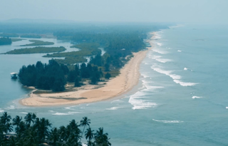
Cherkady is a village in the southern state of Karnataka, India. It is located in the Udupi taluk of Udupi district in Karnataka.
Kirimanjeshwara is a village in the southern state of Karnataka, India It is well known for Shri Agasthyeshwara temple. It is located in the Byndoor taluk of Udupi district in Karnataka.
Navunda is a village in the southern state of Karnataka, India. It is located in the Byndoor taluk of Udupi district in Karnataka.(shrish)
Paduvari is a locality in Byndoor Town, Karnataka, India.It is a part of Byndoor Town Panchayat. It is located in the Byndoor taluk of Udupi district in Karnataka.
Uppunda is a large village in Byndoor Taluk with west coast of the village on the Arabian Sea in South India. The nearest city with an airport is Mangalore which is about 119 kilo-meters away. The town is reachable by water and road from Mangalore. Nearest railway station Byndoor Mookambika Road(BYNR) railway station. It is located in the Byndoor taluk of Udupi district in Karnataka.

Yedthare is a locality in Byndoor Town. It is a part of Byndoor Town Panchayat. India. It is located in the Byndoor taluk of Udupi district in Karnataka.

Ajri is a village in Kundapura taluk, Udupi district, Karnataka, India.
Byndoor is a coastal town and headquarters of Byndoor Taluk in the Udupi District of Karnataka state, India. It is about 450 kilometres (280 mi) from the state capital Bengaluru and 60 kilometres (37 mi) from the Udupi district headquarters. It has an area of 67.0536 square kilometres (25.8895 sq mi) and a population of 24,957 in 2011. It lies in the foothills of Western Ghats on one side and a virgin Someshwar Beach on the other side. The Mookambika Road Byndoor railway station focuses on the pilgrims visiting the Kollur Mookambika Temple which is 28 km from Byndoor. Near by another railway station name is Bijoor, As many as 26 villages including Shiroor, Paduvari, Yadthare, Taggarse, Uppunda, Nandanavana, Kergalu, (Naikanakatte) Bijoor, Kirimanjeshwar, Ullur, Khambadakone, Heranjalu, Navunda, Badakere, Maravanthe, Hadavu, Naada, herur, Kalthodu, Golihole, Yalajith, Kollur, Jadkal, Mudoor, and Hallihole have been brought together under the Byndoor taluk.

Mookambika Road Byndoor is a railway station in coastal Karnataka in South India. Its four-letter code is BYNR. Mookambika Road Byndoor is the main railway station in the town of Byndoor in Udupi district. It serves Byndoor city which is 1 kilometre away from the station. It is the nearest railway station to the famous pilgrimage centre, Kollur Mookambika temple. The distance from Byndoor railway station to Kollur Mookambika temple is about 28 km which can be covered in 40 minutes to one hour by road. Trains from here connect the city to prominent state capitals of India like Bangalore (Karnataka), Thiruvananthapuram, Mumbai and so forth. It is also well connected to the major railway stations such as Goa (Madgoan), Udupi, Mangalore, Kasaragod and Ernakulam. Rail connectivity in Byndoor was established in 1997. A total of 34 express and passenger trains halt here; there was one originating and terminating trains at this station: Mookambika Road–Kannur Passenger train; however this service was terminated in 2017 within two years of service due to lack of revenue generation. Although the railway station caters to a lot of passengers and superfast trains on a daily basis, it does not have a siding line or passing loop. Any crossing of trains can only happen either on Bijoor or Shiroor railway stations 19 km apart.
{{Infobox settlement | name = Taggarse | other_name = | nickname = | settlement_type = Town | image_skyline = | image_alt = | image_caption = | pushpin_map = | pushpin_label_position = right | pushpin_map_alt = | pushpin_map_caption = Location in Karnataka, India | coordinates = | subdivision_type = Country | subdivision_name = India | subdivision_type1 = State | subdivision_name1 = Karnataka | subdivision_type2 = District | subdivision_name2 = Udupi | established_title = | established_date = | founder = | named_for = | parts_type = Talukas | parts = Byndoor | government_type = | governing_body = Town Panchayat | unit_pref = Metric | area_footnotes = | area_rank = | area_total_km2 = | elevation_footnotes = | elevation_m = | population_total = 24968 | population_as_of = 2001 | population_rank = | population_density_km2 = auto | population_demonym = | population_footnotes = | demographics_type1 = Languages | demographics1_title1 = Official | demographics1_info1 = [[Kannada],[Konkani]] | timezone1 = IST | utc_offset1 = +5:30 | postal_code_type = | postal_code = | registration_plate =KA | website = www.baindurutown.mrc.gov.in
Kambadakone, is a village in Byndoor Taluk, Udupi District, Karnataka, India. As per the census of India 2011, the total population of Kadambakone village is 3806, of which 1819 are males and 1987 are females. The name comes from the Kadamba Empire, which once ruled this area. The livelihood of the people in the village mainly depends on agriculture and fishing. The nearest railway stations are Bijoor Railway Station and Mookamabika Railway Station Byndoor.
Jadkal is a village in Byndoor Taluk, Udupi district, Karnataka, India. As per the census of India 2011, the Jadkal Grama Panchayat, which consists of the two villages of Jadkal and Mudoor, had a total population of 7000. The livelihood of the people in the village mainly depends on agriculture and fishing. The nearest railway stations is Mookambika Road Byndoor railway station.
Hallihole , is a village situated in Byndoor Taluk, Udupi District. Village has population of 2328 as per census data of 2011, in which male population is 1103 and female population is 1225. Total geographical area of Hallihole village is 2930.23 Hectares. Population density of Hallihole is 1 persons per Hectares. Total number of house hold in village is 495. As per the Census Data 2011 there are 1111 Femals per 1000 males out of 2328 total population of village. There are 1470 girls per 1000 boys under 6 years of age in the village. Out of total population total 1548 people in Hallihole Village are literate, among them 816 are male and 732 are female in the village. Total literacy rate of Hallihole is 72.92%, for male literacy is 80% and for female literacy rate is 66.36%.